Between the 16-24 April 2026 participated a New Scientist Discovery Tours entitled “Uncovering Vesuvius, Pompeii and Ancient Naples“, and organised by Kirker Holidays. This trip included…
18 April – National Archaeological Museum (my review)
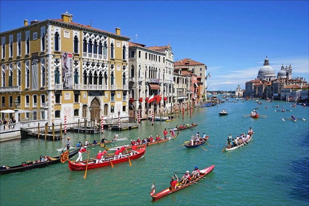
19 April – Visit to Pompeii (my review)
20 April – Visit to Herculaneum (my review) and Villa Oplontis (my review)
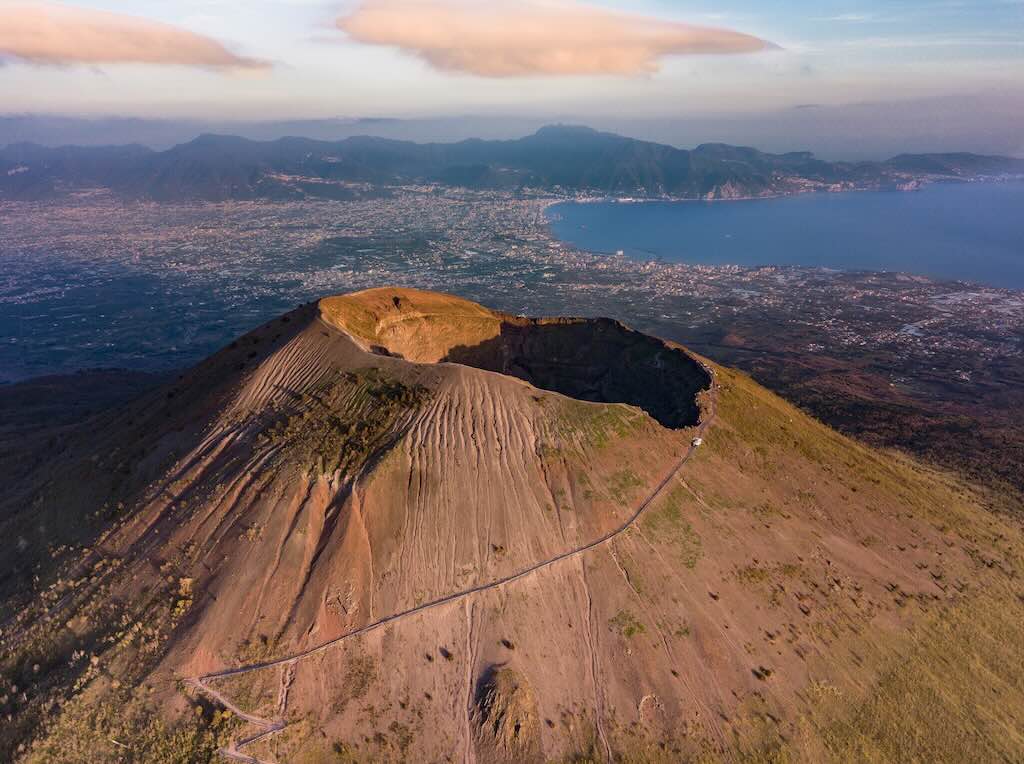
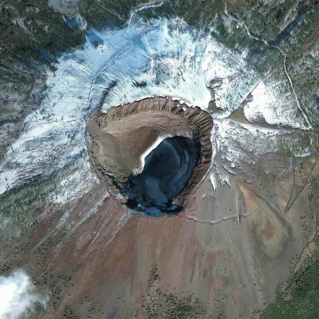
21 April – Visit to Mount Vesuvius (my review)
And I added 3 more days:-
17 April – Visit to the Royal Palace of Capodimonte (my review)
22 April – Making Pizza Napolitano and Tiramisu (my review)
23 April – Visit to Paestum (my review)
I also have a separate post on Borgo Santa Lucia, in Naples, and a review of the Grand Hotel Santa Lucia.
We also received two pdf documents:-
Pre-tour reading “Uncovering Vesuvius, Pompeii and ancient Naples”
Christopher Kilburn “Uncovering Vesuvius”
This particular post provides focuses only on Mount Vesuvius, not on Pompeii or other sites in the region around Naples.
More generally, there are a multitude of websites and YouTube videos dedicated to this particular volcano. So after pointing to some interesting information websites and good YouTube videos, I will focus on historical descriptions of past eruptions of Vesuvius, and how scientists monitor Vesuvius today.
But first, let’s look at…
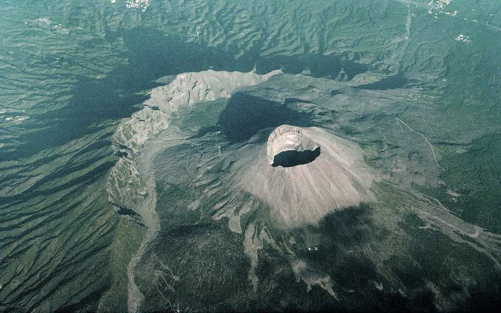
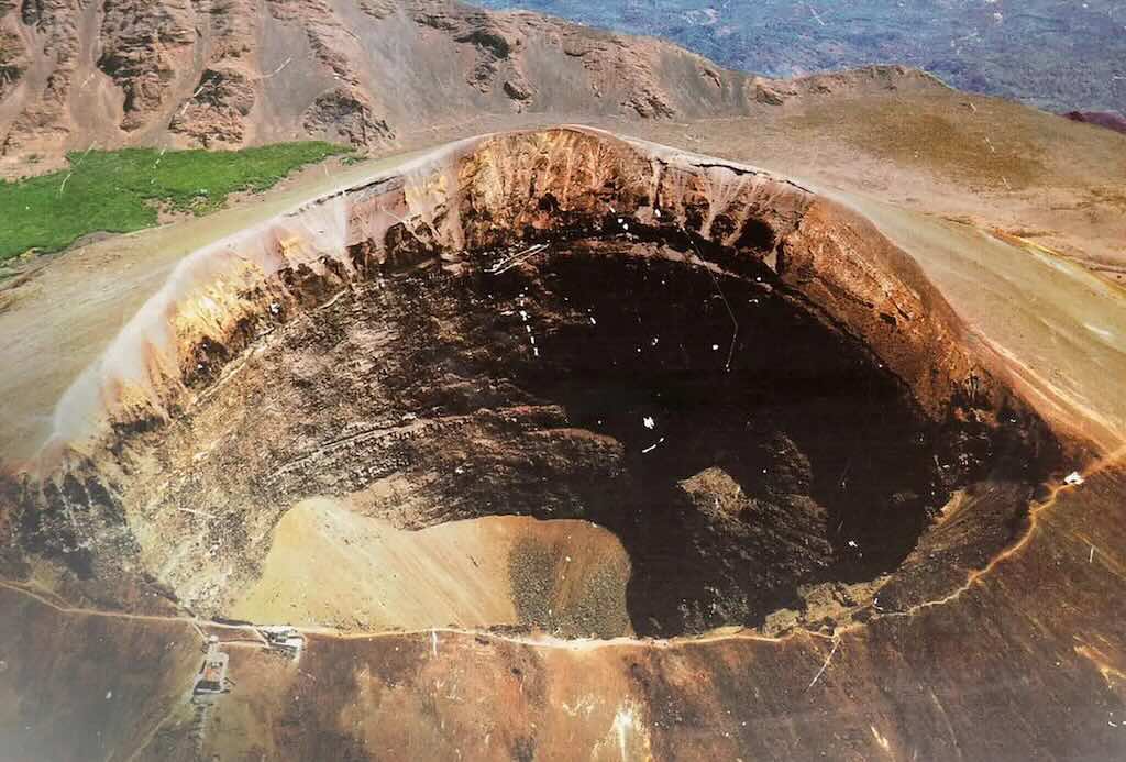
Information about Mount Vesuvius
Wikipedia has a specific article on the Eruption of Mount Vesuvius in 79 AD, and also articles on Mount Vesuvius and on Plinian eruptions.
There is an Istituto Nazionale di Geofisica e Vulcanologia, and there is also an Osservatorio Vesuviano which publishes a bollettino mensile (monthly report) on the actual situation of the volcano (both websites are extensive but appear to be only in Italian).
There are a variety of videos on YouTube under the search “Istituto Nazionale di Geofisica e Vulcanologia”, “ingv”, and “osservatorio vesuviano”.
Vesuvius is one of the Decade Volcanoes, defined by their history of large, destructive eruptions and proximity to densely populated areas.
Background Reading
Video Descriptions
In this very accessible 25 minute video we learn what Italy was like millions of years ago? The answer is surprising, because the Italian peninsula didn’t exist. In fact, Sicily was close to Africa, and Sardinia was more closely linked to France. In this journey through time, the video retraces 250 million years of geological evolution, from the breakup of Pangea to the birth of the Alps and the Apennines, up to the formation of the modern Mediterranean Sea.
The above video of 80 minutes is a journey through nature, science, and humanity that takes us to the slopes and into the history of Etna, Vesuvius, Stromboli, and the Phlegraean Fields. In this story, in addition to discovering the geological aspects, you will meet the people who experience volcanoes every day, studying them, fearing them, celebrating them. Four volcanoes, four souls. The Phlegraean Fields, the invisible; the solitude of Stromboli and its island; Etna, life; and Vesuvius, the icon.
The above video might not be a short glossy introduction, but it does discusses the history and science surrounding the eruptions of Vesuvius and other volcanoes in the Calabrian Arc. It is about many volcanoes, other than Vesuvius, but it’s a solid introduction.
The Calabrian Arc is a one-of-a-kind subduction zone, featuring one of the shortest slab segments (<150 km), one of the thickest accretionary wedges, and one of the oldest oceanic crust in the world. Subduction is where one tectonic plate converges with a second plate, the heavier plate dives beneath the other and sinks into the mantle.
Despite a slow convergence rate between these plates, there is still mechanically active intraslab seismicity below 40 km. But it’s true that for the moment its shallow interface shows little signs of seismic activity. Nonetheless, Vesuvius has generated historical large earthquakes and tsunamis, and it is expects to do so again. The only question is when, and with what magnitude.
Professor Agust Gudmundsson is Chair of Structural Geology, Department of Earth Sciences, in Royal Holloway. It’s certainly possible to continue through the 12 lectures, but this first lecture is a good introduction. It covers magma generation, volcano types, and eruption mechanisms.
If the above introduction doesn’t quite “click” for you, try the one below.
If neither of these two introductions “click” for you, my last try will be the one below, even if it is about the Canary Islands. This last video is also available in a free book “The Geology of the Canary Islands” (downloadable online).
The below video looks more at “what to do next time”, and in particular how the urban rescue services are organised. But many people living under the shadow of the volcano have their doubts about how successful any rescue effort can be.
The Science of Volcanology
Taken directly from International Commission on Geoheritage. The references are shown on their webpage.
The science of volcanology was born at Vesuvius, with the first description of the phenomena which occurred during an explosive volcanic eruption. This account is included in two letters by Pliny the Younger to Tacitus about the 79 AD eruption, which destroyed Herculaneum and Pompeii.
Let me insert a comment here. Often the letters are presented as Pliny the Younger (ca- 61-113 AD) documenting the eruption, however the truth is that he was replying to a request. Tacitus (ca. 56-120 AD) has asked Pliny for an account of the death of his uncle, Pliny the Elder (ca. 23-79 AD), so that he could pass on to posterity a more authentic version than he would otherwise have been able to. The letters were from one famous advocate to another. The opening of the letter made it clear that its subject was the death of the elder Pliny, and not the eruption of Vesuvius. The first letter presents the elder Pliny as a dedicated scientist and a man of action. The second presents a younger Pliny whose behaviour resembled that of his famous uncle, and who, in the most testing circumstances imaginable, was proved worthy of him. This is not to say that the letters are not a fantastic first-hand account of the eruption, but would Pliny the Younger have written them, if not requested by Tacitus?
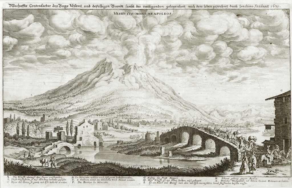
During the following centuries, the major eruptions of Vesuvius (e.g. 472 AD, 1631, 1906, and the last in 1944) were taken as a paradigm for the study of all possible volcanic activity by European scientists. From the 18th century to date, Vesuvius and its crater have been visited by many scholars and is considered a natural laboratory for understanding the behaviour of an active volcano.
Volcanic activity at Vesuvius started about 400,000 years ago (Sbrana et al., 2022). Outcropping deposits all belong to the volcanic activity following the Campanian Ignimbrite (about 39,000 years ago). Dated to about 22,000 years ago, the Pomici di Base eruption is the major Plinian eruption that occurred at Vesuvius. Other major explosive eruptions followed, such as the Greenish Pumices Sub-Plinian eruption (about 20,000 years ago), and the Pomici di Mercato Plinian eruption (about 8,900 years ago). Activity during the last 4,000 years can been subdivided into four periods:
- Proto-Vesuvius, between Plinian eruptions of Pomici di Avellino (about 4,000 years ago) and 79 AD
- Ancient Vesuvius, between 79 AD Plinian eruption (Sigurdsson et al., 1985) and 472 AD Sub-Plinian eruption
- Medieval Vesuvius, from 472AD Sub-Plinian eruption and 1631 small-scale Plinian eruption (Rosi et al., 1993)
- Present Vesuvius, between 1631 and 1944 eruptions. Medieval Vesuvius is characterised by lava flows from vents on the slopes of the Vesuvius cone, and of Strombolian and Violent Strombolian scoriae fallout (Principe et al., 2004). During Present Vesuvius period, the volcano passed from effusive and markedly Strombolian activity to episodes of violent Strombolian and Sub-Plinian eruptions with mixed effusive and explosive character (Arrighi et al., 2001).
Since the last eruption in 1944, Vesuvius has entered a period of eruptive rest.
Positioned on the outskirts of Naples, Vesuvius has been studied by travellers, scholars, naturalists and scientists, particularly after the devastating eruption of 1631 (Rosi et al., 1993). For centuries volcanologists described volcanoes by comparison with Vesuvius. Consequently, the available documental record on Vesuvius is one of the best of the world (BIBV database).
The BIBV means the Bibliografia del Vesuvio, which is said to be compiled and maintained by Italian research institutions, especially, Istituto Nazionale di Geofisica e Vulcanologia (INGV). However, I have not been able to identify a simple link, so my best advice is to search INGV for “Vesuvio”.
For me it was not immediately obvious what a Sub-Plinian eruption and a small-scale Plinian eruption were, as compared to a Plinian eruption.
Firstly, a Plinian eruption is one of the most powerful types of volcanic eruptions. It is named after Pliny the Younger (ca. 61-113 AD), who described the 79 AD eruption of Mount Vesuvius. This means a very high eruption column (often 20–40+ km into the stratosphere), a sustained, continuous explosion driven by gas-rich magma, which produces vast amounts of pumice, ash, and volcanic gases, and forms a distinctive “umbrella cloud” at the top. Finally this often leads to pyroclastic flows when the column collapses.
A Sub-Plinian eruption is essentially a scaled-down version of a Plinian eruption. This means a moderate column (typically ~10–20 km), a strong but not extreme explosion, less sustained, with the same deposits (but less in quantity), and not always a column collapse.
And, as far as I can tell, this still leaves a space for “a small-scale Plinian eruption”. The Sub-Plinian is less stable and more fluctuating than a Plinian eruption, so a small-scale Plinian eruption is just at the lower end of the full Plinian category. It is still a stable and sustained eruption, but the column height might be a little smaller (~15–25 km), yet still with the classic umbrella cloud, and large amounts of ash, etc. And the pyroclastic flows will be typically smaller and less widespread than in large Plinian eruptions.
The Three Most Important Eruptions
Mount Vesuvius is one of the most intensively studied volcanoes in the world, with a documented history of more than 50 eruptions over roughly 17,000–20,000 years. This total comes from a combination of geological evidence (i.e. layers of ash, pumice, and lava) and historical records. Of these eruptions, around 30 occurred after 79 AD, during a long active phase that lasted until the mid-20th century. Its location near densely populated areas, especially Naples, makes it particularly dangerous and closely monitored today, even though it has been dormant since 1944.
It’s important to remember that Mount Vesuvius is a classic subduction-related stratovolcano formed along the convergent boundary where the African Plate is being forced beneath the Eurasian Plate. Its magma is typically andesitic (an intermediate type volcanic rock between silica-poor basalt and silica-rich rhyolite) to phonolitic (an extrusive rock, of intermediate chemical composition between felsic and mafic). Because of its relatively high silica content, the viscosity increases and allows volcanic gases (H₂O, CO₂, SO₂) to become trapped. This pressure buildup is what drives explosive (Plinian and sub-Plinian) eruptions rather than gentle lava flows. Over the last ~20,000 years, geologists have reconstructed those 50+ eruptive events using tephrostratigraphy (layered ash deposits), radiometric dating, and petrological analysis.
Since 79 AD alone, the ~30 eruptions have often been separated by repose periods, an important pattern for hazard forecasting today.
There are three eruptions that can be emphasised because each provides a different kind of high-value scientific information:-
- 79 AD is best for understanding eruption physics (detailed eyewitness account, and preserved deposits)
- 1631 is best for understanding long-term behaviour (shift into repeated eruptive cycles and early hazard records)
- 1944 is best for modern monitoring science (instrumental data and direct measurement).
Together, they form a complete scientific record, starting from descriptive observation, to early documentation, to modern measurement.
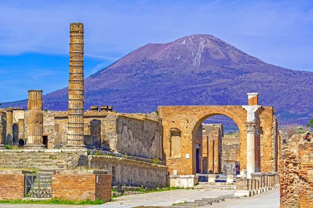
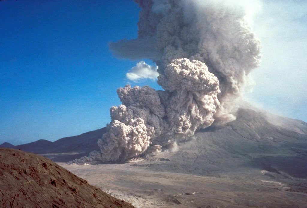
The 79 AD eruption is the type example of a “Plinian eruption”, a term derived directly from the detailed observations of Pliny the Younger (ca. 61-113 AD). His letters to Tacitus are arguably the single most scientifically valuable descriptive record of any ancient eruption. He described a vertical ash column shaped like a pine tree, what modern volcanology recognises as a convecting eruption column reaching ~20–30 km altitude.
From a technical standpoint, the eruption progressed through multiple phases:-
- Plinian phase with a sustained column, widespread pumice fall (white then grey layers reflecting magma composition changes)
- Column collapse where gravitational instability led to pyroclastic flow (pyroclastic density currents)
- Surge phase with fast, low-density flows that caused most fatalities in Pompeii
- High-temperature flows (~300–700°C) that carbonised organic material in Herculaneum.
Modern studies of deposit thickness, grain size, and dispersal patterns have allowed reconstruction of eruption rates (~10⁷–10⁸ kg/s) and column dynamics. The combination of Pliny’s eyewitness account and the exceptionally preserved stratigraphy makes this eruption the benchmark dataset for modelling explosive volcanism worldwide.
The key primary source is Pliny the Youngers’ Epistulae (Letters) Book 6, Letters 16 and 20. This is the only detailed eyewitness account of a Plinian eruption in antiquity. It describes the column shape (“pine tree” form), duration and phases of eruption, and the ash fall, darkness, and ground tremors. Modern volcanology literally uses this text to define “Plinian eruptions”.
The AD 79 eruption of Vesuvius: a reconstruction from historical and volcanological evidence, by Haraldur Sigurdsson, Stanford Cashdollar and Stephen R. J. Sparks (1982). This is a reconstruction of the eruption of Vesuvius in AD 79. When combined with Pliny’s account, it looks at ash layer thickness mapping, grain size distribution, and eruption column modelling. The authors provided the first quantitative reconstruction of the column height (~20–30 km), the mass eruption rate, and the transition from column to pyroclastic flows. They added physics and measurements to Pliny’s descriptive data.
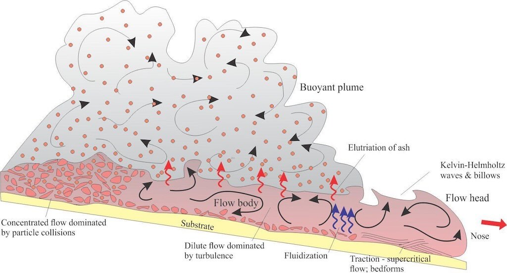
It is really important to focus on what pyroclastic density current (PDC) means, because at Pompeii, this caused most of the fatalities.
A pyroclastic density current is a fast-moving (100–700 km/h), ground-hugging (heavier than air) avalanche made of hot gas, volcanic ash, and rock fragments (pumice, crystals, debris).
Think of it as a turbulent, superheated cloud (~200°C to 700°C) mixed with solid material, flowing downhill under gravity.
So during the eruption the column rose high into the atmosphere. This meant a column hight of 20–30 km created by an eruption that was ejecting roughly 10,000 to 100,000 metric tons per second.
Not surprising, it became unstable and collapsed. Instead of rising further, the material fell back and spread outward along the ground.
This generated pyroclastic density currents, which split into dense flows (hugging the ground), and faster surges (spreading outward and upward). At Pompeii, surges were especially deadly because they reached people quickly, even inside buildings (it can destroy buildings). Temperatures were high enough to cause instant death in many cases, i.e. instant thermal shock (burns internal organs), and suffocation from ash and gas.
After centuries of relative quiet, Vesuvius erupted violently again in 1631. This eruption killed an estimated 3,000–6,000 people and devastated villages around Naples. It marked the beginning of a more active period of eruptions that lasted for centuries. The disaster also led to some of the earliest organised scientific and religious responses to volcanic risk in Europe.
The 1631 eruption is scientifically important because it marks a transition from long dormancy to sustained eruptive cycling. Petrologically, it shows a shift toward more evolved, gas-rich magma systems, likely due to magma differentiation during the repose period. The eruption involved:-
- Explosive opening phase with ash column and tephra (fragmental) fallout
- Lava effusion from flank vents
- Extensive lahars (volcanic mudflows) triggered by rainfall mixing with loose ash.
The most scientifically useful records come from early modern observational reports and chronicles, including accounts compiled by scholars in Naples. While less precise than modern data, these are among the first semi-systematic natural hazard descriptions in Europe, documenting eruption timing, precursors (earthquakes, gas emissions), and impacts. When combined with geological fieldwork on deposits, they allow volcanologists to reconstruct the onset of Vesuvius’s “open-conduit” behaviour, characterised by frequent smaller eruptions between major events.
An open conduit means the internal “pipe” (the conduit) connecting magma deep underground to the crater is not sealed off. Gas and magma can move upward continuously or frequently, rather than being trapped for long periods.
“Dell’Incendio del Monte Vesuvio” is a 1632 Italian prose work by Giulio Cesare Braccini chronicling the catastrophic eruption of Mount Vesuvius in December 1631 (in Italian). Written soon after the event, it is one of the earliest detailed eyewitness and literary accounts of a modern volcanic eruption, blending scientific curiosity, devotional interpretation, and baroque rhetoric.
The 1631 eruption of Vesuvius by Rolandi, Barrella & Borrelli (1993) is a peer-reviewed academic paper published in Journal of Volcanology and Geothermal Research. It provides a detailed volcanological reconstruction of the 1631 eruption of Mount Vesuvius, the most destructive event at the volcano since AD 79. The study is notable for integrating historical accounts, stratigraphic data, and eruption dynamics modelling.
It shows the eruption was sub-Plinian (less intense than 79 AD but still highly explosive).
The study shows the eruption was not a single event, but a multi-stage process:-
- Phase 1 — explosive opening with a sudden violent explosion, ash column rises into the atmosphere, and widespread tephra fall (ash and pumice)
- Phase 2 — column instability and flows, parts of the column collapse, creating pyroclastic density currents that spread around the volcano
- Phase 3 — water-driven disasters, with heavy rain mixing with ash producing lahars (mudflows), that caused a large proportion of destruction and deaths
- Phase 4 — lava effusion, lava flows from vents that were localised but still destructive.
This phased structure is now a standard model for many explosive eruptions.
The paper also used deposits to estimate that the eruption magnitude was a moderate-to-large explosive event, with a column height of several kilometres (lower than 79 AD but still powerful). Deposit thickness varied with distance and direction.
The paper proved that lahars were a major killer. The deadliest processes were not just explosions, but mudflow formed when fresh ash covered slopes and rainfall mobilised it into fast-moving flows. These flows travelled far from the volcano, buried settlements, and occurred after the main eruption. Scientists understood that secondary processes can be as dangerous as the eruption itself.
The study also explains the shift to “open-conduit” behaviour. After 1631 the magma system became more continuously active, meaning that gas and magma could move upward more easily, and Vesuvius entered a period of frequent smaller eruptions (1631–1944).
This directly affected risk planning for the region around Naples today.
The 1944 Eruption
The 1944 eruption is the most scientifically valuable in terms of instrumental data and direct observation. By this time, the Vesuvius Observatory (founded in 1841) had established systematic monitoring, including seismographs, gas measurements, and visual documentation.
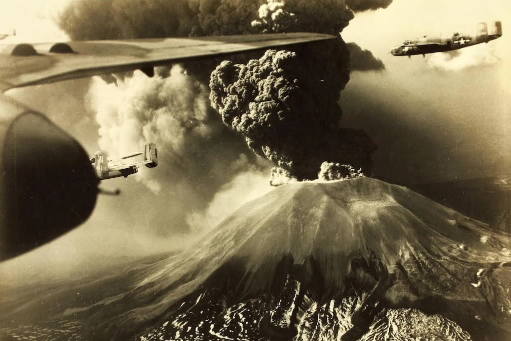
The most recent eruption occurred during World War II. Lava flows destroyed several villages and even damaged Allied military aircraft stationed nearby. Although less deadly than earlier eruptions, it’s significant because Vesuvius has been quiet ever since.
Technically, the eruption was characterised by:.
- Strombolian to weakly Plinian activity (intermittent explosions rather than a sustained column)
- Lava effusion forming flows that destroyed settlements
- Ash emissions that disrupted military operations during World War II.
The most scientifically useful material comes from observatory reports, photographs, and film footage, which provide time-resolved data on eruption dynamics. These records allow modern volcanologists to correlate seismic signals with eruptive phases, improving eruption forecasting models. It is also the last eruption before the current dormancy, making it critical for understanding present-day risk scenarios.
“The Eruption of Vesuvius in 1944” is a detailed volcanological report by Italian geologist Giuseppe Imbò, published in 1949. It documents the last recorded eruption of Mount Vesuvius, offering a comprehensive scientific analysis of its eruptive phases, impacts, and observations from the event. The paper remains a key reference in 20th-century volcanology, but is not easy to find. However there are recent papers that directly uses and reproduces his data and descriptions. What Imbò did was to create a time-resolved eruption log (day-by-day, sometimes hour-by-hour). He linked seismic observations to eruption phases, he descriptions of lava flows, ash fall, and explosions, and made an early attempt to classify eruption style.
Volcanoes of the World is a comprehensive reference source published by the Smithsonian Institution that catalogs all known active and Holocene (past 10,000 years) volcanoes on Earth. It serves as the foundational data source for the Smithsonian’s Global Volcanism Program, which monitors volcanic activity worldwide.
How Scientists Monitor Vesuvius Today
Modern volcano surveillance is inherently multi-parameter, but in practice it is structured around a hierarchy of techniques that differ in both sensitivity to subsurface processes and reliability as eruption precursors.
At the core (Tier 1) are seismology and ground deformation measurements, which together provide the most direct and continuous constraints on magma dynamics. Seismic monitoring resolves brittle failure, fluid-induced fracturing, and sustained volcanic tremor, offering insight into stress redistribution and magma migration pathways. Complementarily, geodetic techniques (e.g. including continuous GNSS (GPS), tiltmeters, and satellite-based InSAR), quantify surface deformation at millimetre precision, allowing the detection of inflation or deflation associated with pressurisation or withdrawal of subsurface magma bodies. These two datasets form the backbone of operational monitoring because they respond rapidly and measurably to changes in the magmatic system.
Tier 2 techniques provide critical supporting constraints on the physicochemical state of the system. Geochemical monitoring, particularly of CO₂ and SO₂ fluxes, as well as groundwater composition, tracks volatile transport from depth, often revealing degassing processes that precede or accompany magma ascent. Gravimetric measurements add a complementary dimension by detecting minute variations in the Earth’s gravitational field, which reflect mass redistribution within the volcanic edifice, such as magma intrusion or fluid movement. Infrasound monitoring, while less directly diagnostic of subsurface structure, captures low-frequency acoustic emissions associated with degassing, explosions, or conduit resonance, providing an additional real-time indicator of eruptive activity, especially under conditions where visual observation is limited.
Tier 3 encompasses techniques that refine interpretation and extend spatial coverage rather than acting as primary early-warning tools. Satellite remote sensing integrates thermal imaging, gas plume detection, and interferometric deformation mapping across regional scales, enabling the detection of subtle or widespread changes not easily captured by ground networks alone. Hydrological and environmental monitoring, such as groundwater level, temperature variations, and meteorological forcing, help disentangle volcanic signals from external influences, particularly in hydrothermally active systems like Mount Vesuvius. Thermal monitoring, whether ground-based or satellite-derived, provides additional constraints on energy flux and the surface expression of subsurface processes.
The central insight emerging from this framework is that no single observable is sufficient to diagnose volcanic unrest with confidence. Instead, modern volcanology relies on the correlation of independent physical signals that reflect different aspects of the same underlying processes. Magma ascent and pressurisation manifest simultaneously as increased seismicity (rock fracturing and fluid movement), measurable ground deformation (elastic response to pressure changes), enhanced gas emissions (volatile exsolution and transport), and, in some cases, gravity anomalies (mass redistribution).
It is only when such signals evolve coherently across multiple monitoring domains do volcanologists infer a significant escalation in eruption probability. This integrative approach is particularly critical at Vesuvius, where the high population density in the surrounding region necessitates a conservative and evidence-based interpretation of all available data streams.
Tier 1 - Seismology
Seismology focuses on detecting and characterising the microseismic activity generated by magma movement, gas pressurisation, and rock fracturing within the volcanic edifice. The primary quantities measured are ground displacement, velocity, and acceleration, which reveal the frequency, amplitude, and waveform characteristics of seismic signals such as volcanic tremor and long-period events. These signals are recorded using high-sensitivity broadband seismometers (for a wide frequency range of ground motion), short-period geophones (optimised for higher-frequency local events), and strong-motion accelerometers (to capture large ground accelerations during energetic episodes). Data from dense seismic networks are analysed to locate hypocenters, track magma ascent pathways, and identify changes in stress conditions, providing critical insights into eruption precursors and real-time hazard assessment.
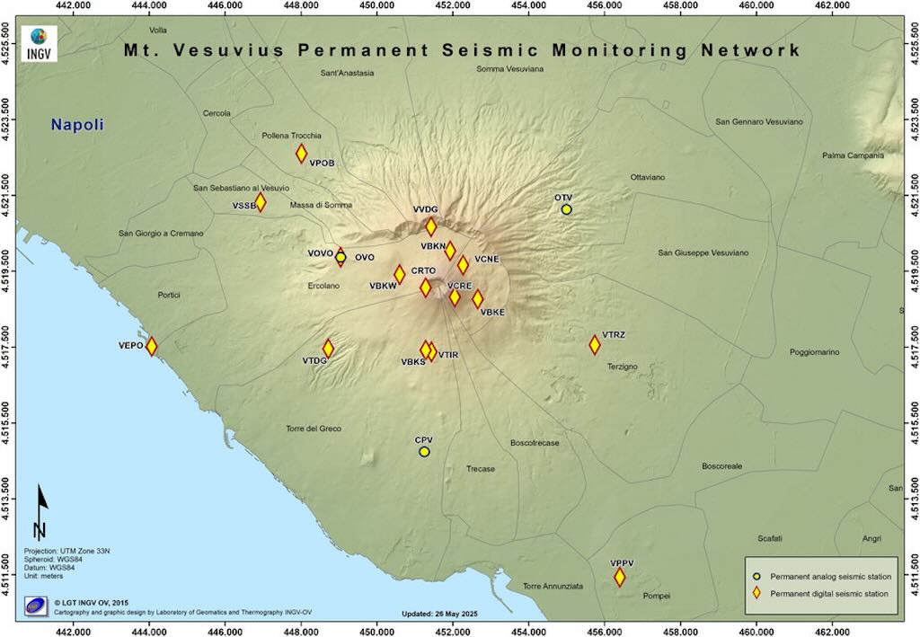
My understanding is that Vesuvius is monitored through a network of 18 different stations. They listed both broadband (0.016–50 Hz) and very wide-band (down to ~0.004 Hz) velocimeters, which can capture high-frequency signals from rock fracturing (volcano-tectonic quakes), and low-frequency signals from magma movement, resonance, and volcanic tremor.
The accelerometers, including the one coupled with the broadband sensor, are a kind of strong-motion sensor. They measures ground acceleration rather than velocity, and complements velocimeters (which are better for weak signals).
Microphones are the main addition beyond classic seismology. They can measure pressure waves in the air (infrasound), not ground motion, and detect gas bursts, explosions, and ash emissions. They’re often used together with seismic data to distinguish underground processes (seismic) from surface/explosive activity (infrasound).
Tier 1 - Ground Deformation
The difference is that seismology measures rapid, transient vibrations, while ground deformation tracks slow, continuous shape changes of the volcano.
Ground deformation measures how the surface physically moves or deforms over time (typically centimetres to meters over days to years), as magma accumulates, migrates, or withdraws beneath the volcano. Instead of vibrations, it tracks displacement and strain using different instruments, e.g. GNSS/GPS stations (precise position changes), tiltmeters (very small changes in slope), and satellite-based InSAR (radar interferometry mapping surface deformation across wide areas).
The GNSS (GPS) system is the core deformation measurement tool because it measures 3D displacement, including vertical (quota) with a millimetre precision. This directly corresponds to ground deformation such as uplift/subsidence produced by magma accumulating or draining, as well as any horizontal motion due to inflation/deflation of the volcano. So this is the most direct realisation of “ground deformation”, a change in position over time.
The tiltmetric network of 7 stations measures tiny angular changes (microradians) as a continuous log. It captures deformation that GNSS might miss early on, slight swelling , or change of direction of the pressure source. It’s especially sensitive to magma pressurisation near the surface.
The mareographic (tidal) network of 3 stations with “galleging sensors” helps track sea level variations, and provides a stable reference for vertical ground movement. This separates volcanic deformation from environmental effects.
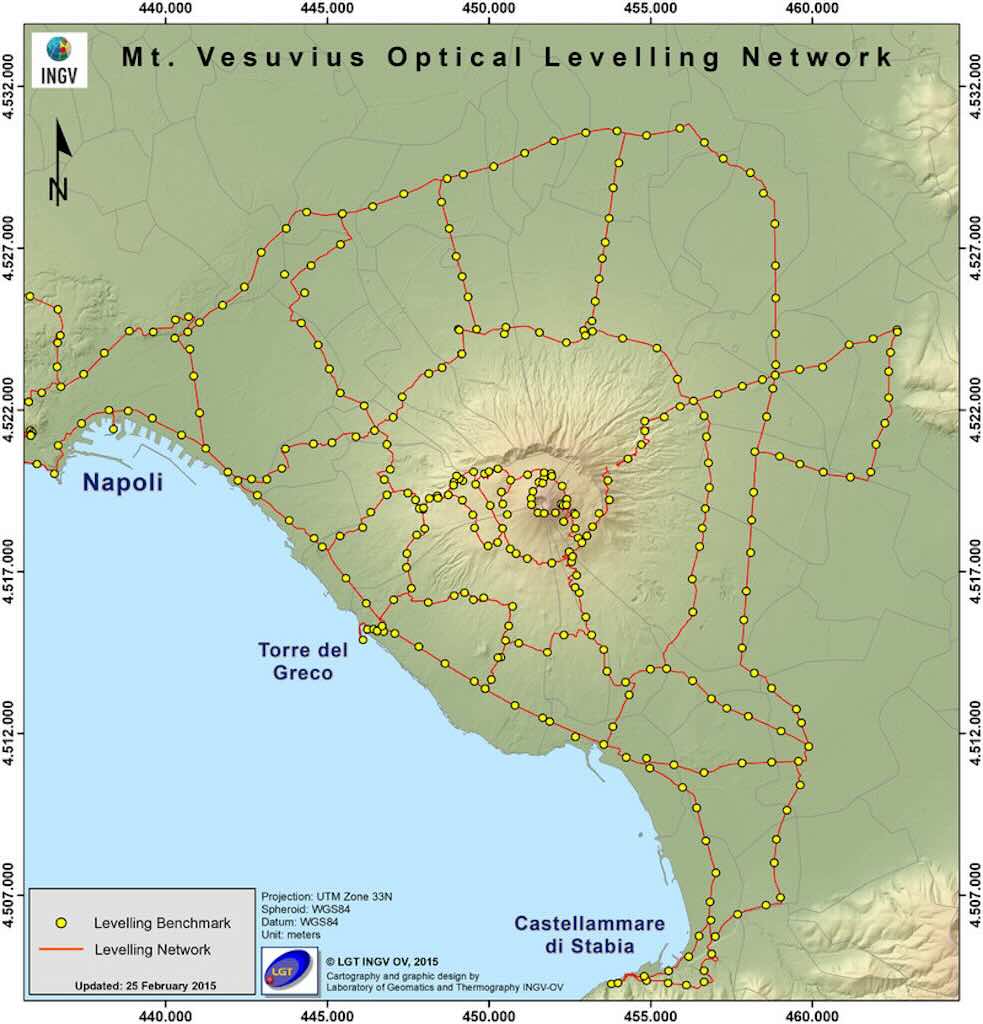
The altimetric network (precision levelling) monitors vertical deformation over a 270 km, consisting of 359 benchmarks and 21 concatenated circuits. This measures height differences between fixed points with very high accuracy, and would detect slow uplift or subsidence trends, and the long-term evolution of the volcano.
Gravimetry measures changes in gravity at 3 different stations. This relates to any mass redistribution (e.g. magma entering a chamber) or density changes underground. It complements deformation, in that uplift (detected by GNSS) and gravity increase would point to magma intrusion. Whereas uplift without gravity change would suggest pressure changes, but not new mass.
InSAR (satellite radar interferometry) is wide-area deformation mapping using satellites such as Sentinel-1 and COSMO-SkyMed. This measures surface displacement over large areas, to millimetres. It can detect regional patterns and see deformation where no instruments are installed.
Tier 2 - Geochemical Monitoring
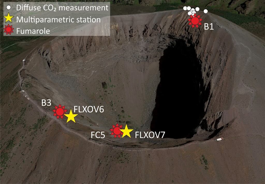
On Vesuvius CO₂ flux is the rate at which carbon dioxide escapes from the ground, and is one of the earliest and deepest-sourced volcanic gases. It exsolves (separates from magma) at high pressure, and it can migrate upward through fractures before magma itself moves significantly. On the Vesuvius they have two multiparametric stations, one on the crater rim, and one on the crater bottom area. They continuous measure the CO₂ flux of the soil, the temperature of the main fumarole and the soil temperature gradient. This helps separate deep magmatic signals from shallow hydrothermal and structural effects, and track how gas, heat, and pressure evolve within the volcanic system.
Tier 3 - Thermal Camera Network
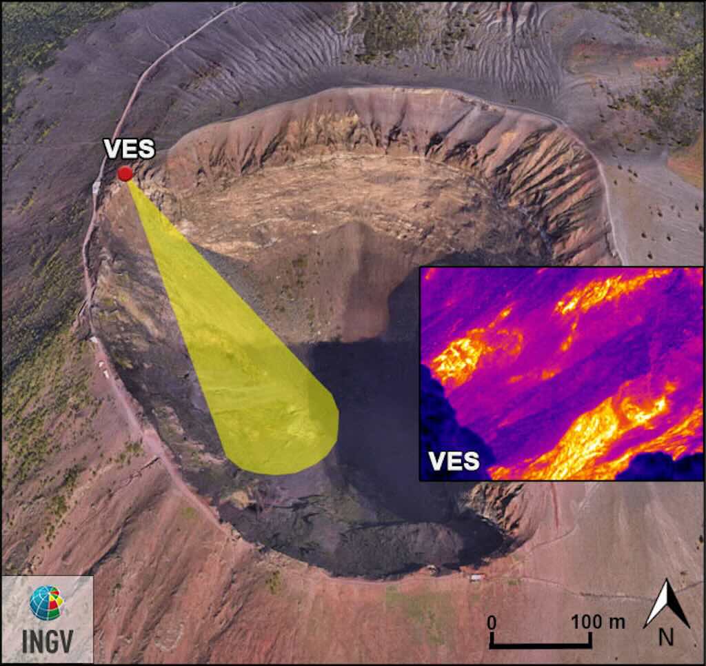
There is a thermal imaging camera permanently installed to view the southwestern inner slope of the Vesuvius crater, which is affected by a significant thermal anomaly. This produces heat maps of the crater slope, and temperature changes in fumaroles.
Measurements are also made monthly (mostly at night), using a portable, high-resolution thermal camera, and a thermocouple.
High CO₂ and a high temperature change would suggest a deep gas, implying magmatic movement. And high CO₂ with a low temperature change, would just be gas movement without major heat increase (permeability change).