Expedition to Southern Lands
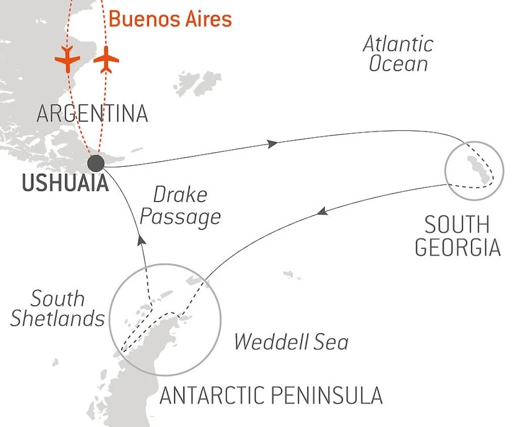
This post is the third part of a day-by-day timeline and travel itinerary of the expedition cruise to the “Southern Lands”. The cruise started out from Ushuaia in Tierra del Fuego (Day 1) and crossed the Scotia Sea to visit South Georgia through to Day 7. Then the cruise turned back (Day 8) to again cross the Scotia Sea, but this time along the South Scotia Ridge. Destination the South Shetland Islands (Day 10) and the Antarctic Peninsula (Day 11), before finally returning to Ushuaia on Day 17. This third part describes Day 12 to Day 17.
- Antarctic on Le Lyrial (Days 1-7)
- Antarctic on Le Lyrial (Days 8-11)
- Antarctic on Le Lyrial (Days 12-17)
In February 2025 this particular itinerary no longer appeared on the Ponant website.
This blog posting tries to touch on a number of specific questions, namely:-
- What’s the Differences between Ushuaia, South Georgia, South Shetland Islands, the Antarctic Peninsula and the Antarctic mainland?
- Are the Landscapes of South Georgia, South Shetland Islands, and the Antarctic Peninsula Different?
- Why Are There Fossils in Antarctica and its Subantarctic Islands?
- Why are Elephant Seals so Aggressive?
- Can You Tell the Difference Between a Young Female Elephant Seal and an Young Female Antarctic Fur Seal?
- How Did Antarctic Fur Seals Evolve, Survive, and Thrive?
- Who Hunted Seals and Why?
- Who was Thomas Chapman and What Did He Do?
- What’s so Alien about Deception?
- My Name is Deception, Will I Deceive in the Future?
And the visits to Hannah Point, Telefon Bay, Wilhelmina Bay, Danco Bay and Portal Point.
There is a YouTube video summary of this particular trip.
The best travel summary I’ve seen is the 11-part Quest for the Antarctic Circle. The photos are superb.
I have numerous other blog pages covering other aspects of this exploration itinerary:-
- Planning a Cruise to the Antarctic
- My Antarctic Packing List
- Le Lyrial – A Luxury Expedition Cruise Ship
- Le Lyrial – Exploring Hidden Engineering
- Air Dolomiti Embraer E195
- Lufthansa Business Class Lounge, Frankfurt
- Lufthansa Boeing 747-8 – Business Class
- Ministro Pistarini International Airport, Buenos Aires
- Hotel Meliã Recoleta, Buenos Aires
- Hotel Sofitel Recoleta, Buenos Aires
- Hotel Palladio, Buenos Aires
- Lufthansa Boeing 747-8 – First Class
- Lufthansa First Class Lounge, Frankfurt
And:-
I also have a separate blog post for my visit to the Museo Nacional de Bellas Artes, Buenos Aires.
On December 2, 2024 we had visited Saint Andrews Bay and Gold Harbour in South Georgia (Day 7). The next part of the cruise (Days 8 and 9) involved leaving South Georgia and sailing towards the South Shetland Islands (Day 10), then on to Brown Bluff (Day 11) on the Tabarin Peninsula, the northeastern tip of the Antarctic Peninsula.
Over the next few days we would ballad back and forth between the South Shetland Islands and the Antarctic Peninsula. Firstly, a visit to Hannah Point and Telefon Bay in the South Shetlands (Day 12). Then Wilhelmina Bay and Danco Bay on the Antarctic Peninsula (Day 13).
Our programme of excursions terminated with a visit to Portal Point and a trip back to the eastern part of Wilhelmina Bay, both again on the Antarctic Peninsula (Day 14).
Finally we would have to cross the Drake Passage, back to Ushuaia, and fly back to Buenos Aires (Days 15 to 17).
The YouTube video “Drake Passage: The World’s Most Dangerous Sea Route” provides an accessible and interesting overview of the importance of the Drake Passage.
What's the Differences between Ushuaia, South Georgia, South Shetland Islands, the Antarctic Peninsula and the Antarctic mainland?
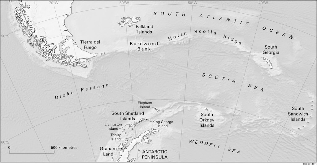
Ushuaia (Tierra del Fuego, Argentina)
- Located at 54°S, Ushuaia is the southernmost city in the world, positioned along the Beagle Channel, a glacially carved strait.
- It sits in the Fuegian Andes, a southern extension of the Andes mountain range, with peaks reaching ~1,500 m and shaped by Pleistocene glaciation (from 2.58 million years ago and ongoing).
- The region has a rugged coastline with fjords, peat bogs, and subantarctic forests, primarily of Nothofagus (southern beeches).
- Ushuaia is separated from Antarctica by the Drake Passage, an intense oceanic convergence zone where the Pacific, Atlantic, and Southern Ocean meet.
- It has a subpolar oceanic climate (Köppen classification: Cfc), with high humidity, strong westerly winds, and cool temperatures (summer max. ~10°C, winter min. ~-2°C).
- Ushuaia has a permanent population of ~80,000 people, with a mix of Argentine locals, scientists, and tourism workers.
- It is a major gateway for Antarctic expeditions, housing research facilities and logistical bases.
- The economy is driven by tourism, electronics manufacturing, and fishing, with a strong naval and scientific presence.
South Georgia (Subantarctic Island, UK)
- A remote island at 54–55°S, South Georgia is an exposed section of the Scotia Arc, a submerged mountain chain linking the Andes to the Antarctic Peninsula.
- It is heavily glaciated, with over 160 glaciers and mountains exceeding 2,900 m (e.g. Mount Paget).
- South Georgia is part of the Scotia Arc, a remnant of an ancient volcanic island arc formed during the break-up of Gondwana. It consists mainly of metamorphic rocks (schists, phyllites) and ophiolites (oceanic crust remnants).
- Unlike Ushuaia, it has no trees, only tundra vegetation, mosses, and lichens, but it supports massive seabird and marine mammal populations.
- Surrounded by the Antarctic Circumpolar Current, it experiences harsher, windier conditions than Ushuaia, with year-round temperatures close to 0°C.
- Historically important for whaling stations, it is now a protected area with some of the most rapidly retreating glaciers in the subantarctic.
- There is no permanent human population, but a small rotating staff (20–40 people) reside at King Edward Point, a UK-run research station.
- In the past, it was a hub for whaling and sealing (1904–1965), with stations like Grytviken abandoned but preserved as a heritage site.
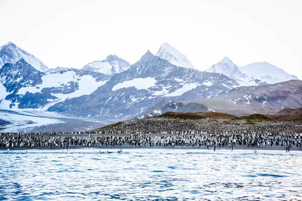
- The island hosts one of the largest wildlife concentrations on Earth, including millions of penguins, seals, and seabirds, but no native land mammals.
South Shetland Islands (Antarctic Archipelago, off the Peninsula)
- This volcanic island chain at 61–63°S lies ~120 km north of the Antarctic Peninsula, forming part of the South Shetland Trench, a subduction zone.
- Unlike South Georgia, these islands are part of the Antarctic Plate, geologically linked to the continent. You find predominantly volcanic and sedimentary rocks.
- Over 80% of their surface is covered in glaciers, but they have some of Antarctica’s largest ice-free areas, which support mosses, lichens, and seabirds.
- Deception Island, one of the most geothermally active areas in Antarctica, has an active caldera where hot springs and ice-free beaches occur even in winter.
- The climate is more Antarctic than subantarctic, with temperatures ranging from -5°C in winter to ~2°C in summer, but buffered by oceanic influence.
- The islands host multiple research stations, making them one of the most human-occupied parts of Antarctica.
- Summer population: ~1,000 people, Winter: ~200 (rotating scientists, military personnel, and logistics staff).
- King George Island, the largest and most inhabited, hosts stations from Argentina, Chile, Russia, China, and others, including a small airstrip for Antarctic logistics.
- Deception Island, an active volcanic caldera, was formerly a whaling station and now supports research stations and seasonal visitors.
- The northernmost part of mainland Antarctica, extending ~1,300 km from 63°S to 75°S.
- It is a mountainous, glaciated extension of the Andes, separated from South America by the Scotia Arc and the Drake Passage.
- Characterised by fjords, floating ice shelves (e.g. Larsen Ice Shelf), and rapidly retreating tidewater glaciers.
- It’s mainly granite, diorite, and metamorphic rocks, with some volcanic features.
- Unlike the rest of Antarctica, it has seasonal melting, and some areas experience rain instead of snow due to recent climate change.
- It hosts Antarctica’s only vascular plants (Deschampsia antarctica and Colobanthus quitensis).
- The peninsula is experiencing one of the fastest warming trends on Earth, with a temperature rise of over 2.5°C in the last 50 years.
- The most populated region of Antarctica, with dozens of research stations operated by Argentina, Chile, the US, the UK, and others.
- Summer population: ~2,000 people, Winter: ~1,000, mostly scientists and support staff.
- Esperanza Base (Argentina) has a small, year-round civilian population, including families and even a school, making it one of the few Antarctic settlements with permanent residents.
- Unlike the Antarctic interior, the Peninsula supports two vascular plants, penguin rookeries, and large populations of seals and seabirds.
- The vast continental landmass, extending from the coast to the high-altitude East and West Antarctic Ice Sheets, covering ~14 million square-kilometres.
- The East Antarctic Ice Sheet (EAIS) is geologically ancient and stable, sitting on a Precambrian craton, while the West Antarctic Ice Sheet (WAIS) is more geologically active, with a rift system similar to the East African Rift.
- Most of the interior is an ice desert, with mean annual temperatures of -40°C to -80°C and minimal precipitation (<50 mm per year, as dry as the Sahara).
- The Transantarctic Mountains, stretching ~3,500 km, divide the continent and act as a geological boundary between East and West Antarctica.
- Katabatic winds, driven by the high-altitude ice sheets, can exceed 300 km/h, making parts of the mainland some of the windiest places on Earth.
- Unlike the Peninsula, the interior remains geologically stable, but coastal areas experience glacial calving and warming-driven ice loss, particularly in West Antarctica.
- The least inhabited region on Earth, with no indigenous population or permanent civilians.
- Hosts scientific research stations, primarily along the coast and in the high interior, with some of the most extreme working conditions.
- Summer population: ~1,200 people, Winter: ~250–300, mostly at bases like Amundsen-Scott (US, South Pole), Vostok (Russia, coldest station on Earth), and Concordia (France-Italy, used for space research due to its isolation and extreme environment).
- Unlike the Peninsula, no vascular plants exist. Life is restricted to microbes, lichens, and small invertebrates in dry valleys and subglacial lakes.
Are the Landscapes of South Georgia, South Shetland Islands, and the Antarctic Peninsula Different?
Complicated question, with a simple answer. Yes, and you can see the difference.
South Shetland Islands (Volcanic Arc)
- Lower-lying volcanic islands, with smoother terrain in some areas.
- Black volcanic sand beaches, especially on Deception Island.
- Active fumaroles, hot springs, and sulphur deposits (volcanic activity).
- Basaltic lava flows and pyroclastic deposits on some islands.
- Frequent seismic activity and signs of past eruptions.
Antarctic Peninsula (Continental Landmass)
- Large mountain ranges, often covered in thick ice.
- Granite and metamorphic rock formations, often exposed near the coast.
- Deep fjords and glacial valleys, carved by ice movement.
- No active volcanic features, though some old volcanic rocks may be found.
- More extensive ice cover than South Georgia or the South Shetlands.
7 December 2024 - Hannah Point and Telefon Bay (Day 12)
Calm night, woke around 04:00 local time.
Temperature 1°C and a 14-16km/h wind during the day.
Sunrise was at 03:03 and sunset at 22:46.
The day started with breakfast at 07:00, and I did not attended the Casino Night! at 21:30.
Excursion - Hannah Point
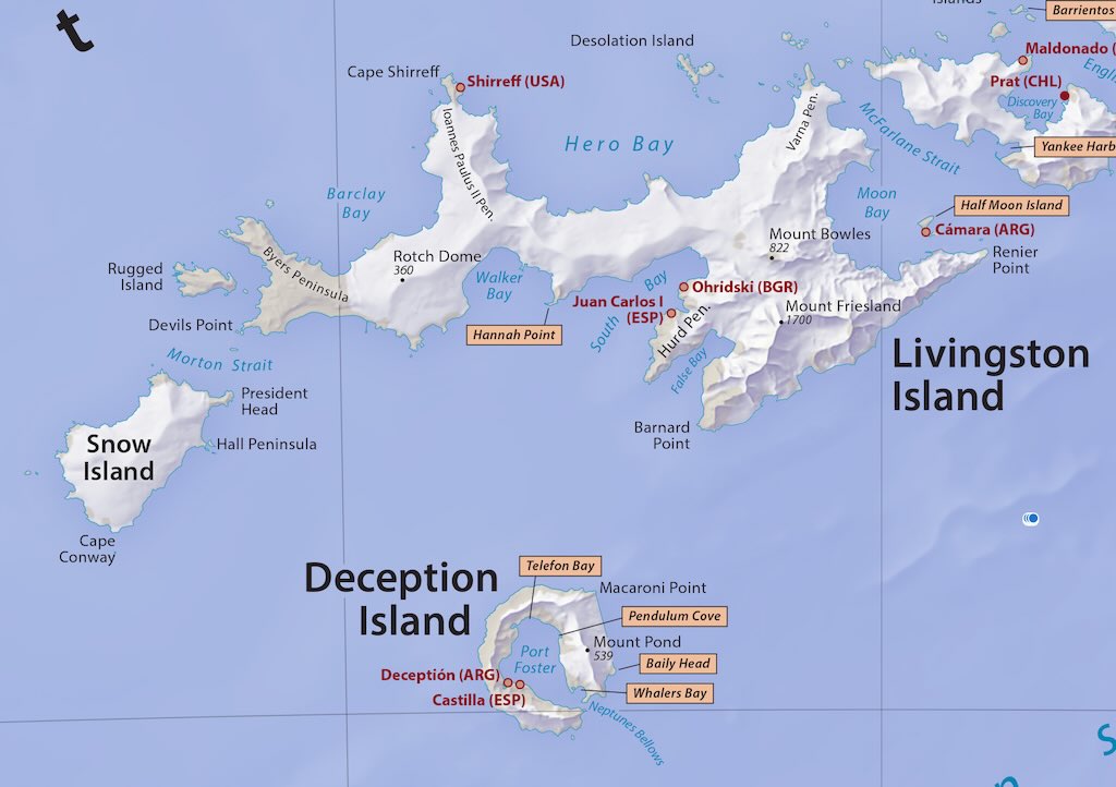
Hannah Point is a prominent headland on the south coast of Livingston Island, one of the largest islands in the South Shetlands Archipelago, located off the northern tip of the Antarctic Peninsula. It marks the western entrance to Walker Bay and the eastern boundary of South Bay.
Livingstone Island was named not because David Livingstone explored Antarctica, but because his name captured the imagination of early Antarctic explorers and cartographers. In the mid‐19th century, David Livingstone’s legendary journeys in Africa made him one of the most celebrated figures of the Victorian era. When British expeditions later began charting the vast, unknown regions of Antarctica, it was common practice to honour notable explorers from earlier eras by naming new geographical features after them.
Walker Bay was probably named after a certain Walker, an early seafarer and chart‐maker.
Livingston Island itself is one of the most accessible and frequently visited locations in Antarctica due to its proximity to King George Island (where research stations and airstrips are located).
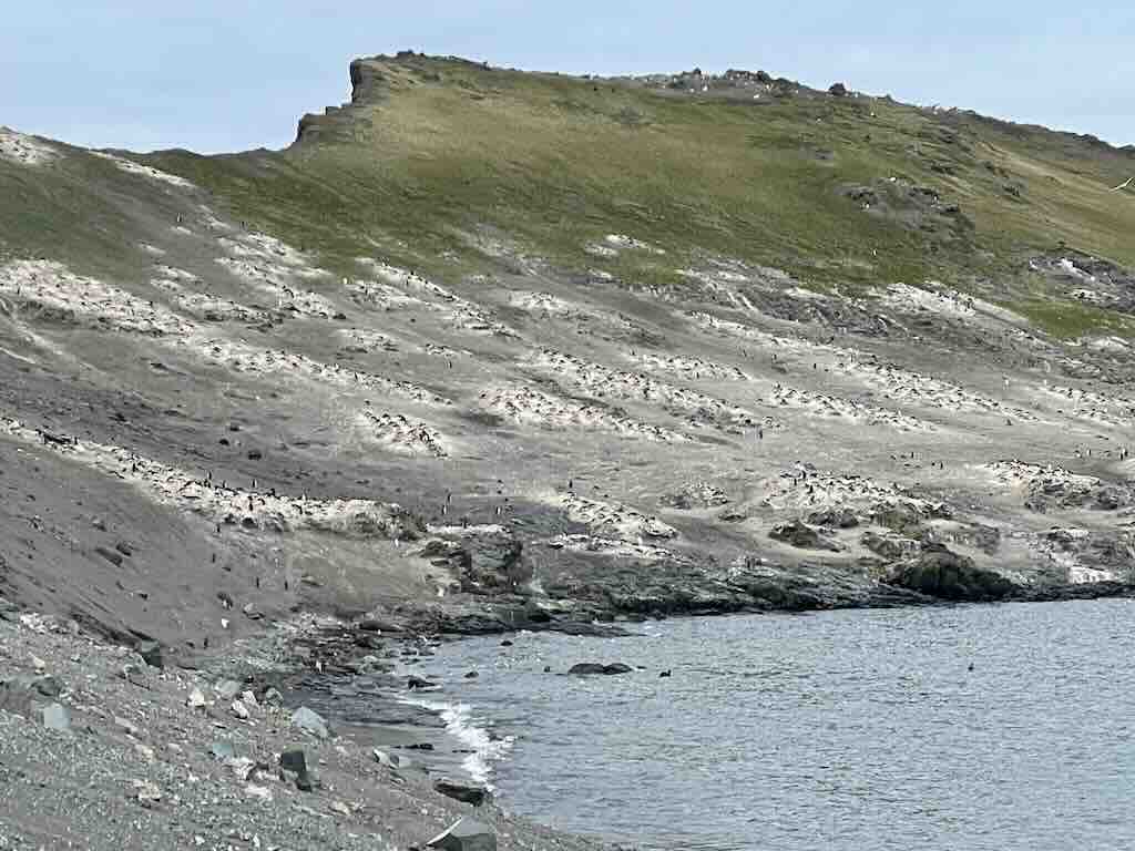
Hannah Point is particularly well-known for its abundant and diverse wildlife, especially during the Antarctic summer (November to March). As seen above, it’s home to large nesting populations of Gentoo penguins (Pygoscelis papua) and Chinstrap penguins (Pygoscelis antarctica) and the beaches near Hannah Point often host Southern Elephant seals (Mirounga leonina) and Antarctic Fur seals (Arctocephalus gazella).
Hannah Point is a rocky promontory with steep cliffs, adjacent ice-free terrain, and mixed volcanic and sedimentary formations. The terrain includes a variety of lithologies, including andesitic and basaltic lava flows, pyroclastic deposits, and sedimentary sequences related to the region’s complex geological history.
Fossil discoveries in the area have revealed Mesozoic-era plant fossils, making it of interest to paleontologists. There is a small collection of fossils and rocks which can be inspected by visitors.
Visitors can experience dramatic contrasts between black volcanic rock, white snowfields, blue icebergs, and the rich brown and green hues of plant life.
The South Shetland Islands were first discovered in 1819 by British and American sealers exploring the Antarctic for new hunting grounds. During the early 19th-century sealing boom, British and American expeditions extensively mapped and named features on the islands.
Hannah Point was named after the British sealing vessel Hannah, which operated in the region in the early 1820s. The precise details of its first sighting or naming are not well documented, but it is believed to have been named by early British sealers or later surveyors in reference to the vessel.
The Hannah, like many sealing vessels of the time, was involved in harvesting fur seals for their valuable pelts, which led to a dramatic decline in the seal population in the early 19th century.
Why Are There Fossils in Antarctica and its Subantarctic Islands?
Many people tend to view Antarctica and its subantarctic islands as barren, icy deserts devoid of life. So people are surprised to learn that these regions are home to a rich fossil record.
Firstly, we think of the Antarctic as being a frigid, ice-covered environment, but during the Mesozoic (252 to 66 million years ago) and early Cenozoic (primarily the Paleogene, so about 66 to 23 million years ago) eras, Antarctica was part of the supercontinent Gondwana. It experienced much warmer, even temperate, climates. Fossils of forests, diverse marine life, and even early dinosaurs reveal that the continent once hosted very active ecosystems.
In fact the discovery of fossils that are similar to those in Australia, South America, and Africa supports the theory of continental drift. Many people are not aware that Antarctica was once connected to these landmasses, which helps explain the presence of plant and animal fossils that seem out of place in today’s icy conditions.
The extreme conditions observed today, permanent ice, low temperatures, and limited liquid water, lead many to assume that life has always been sparse in these regions. Fossil discoveries show that Antarctica underwent dramatic climatic changes over millions of years.
South Georgia forms part of the Scotia Arc, and its geology is dominated by sedimentary basins interleaved with volcanic and metamorphic rocks. The sedimentary sequences here span from the Mesozoic into the early Cenozoic, recording marine transgressions and regressions associated with the opening of the Southern Ocean.
The fossil record in South Georgia reflects a warm, shallow marine environment during the Mesozoic, transitioning into cooler conditions in the early Cenozoic as the Antarctic Circumpolar Current became established.
Fossils recovered from South Georgian strata are predominantly marine. Notable finds include a diverse assemblage of molluscs (such as bivalves and gastropods) and echinoderms (including crinoids and ophiuroids, which are closely related to starfish).
Foraminifera (single-celled organisms) and calcareous nannofossils provide critical biostratigraphic markers, allowing researchers to correlate South Georgian sequences with broader global events in the Mesozoic–Cenozoic transition.
The South Shetland Islands are geologically active, with a mix of volcanic rocks and sedimentary basins. Many outcrops, especially on islands like King George Island, contain sequences deposited during the Late Cretaceous to early Paleogene. These strata often record rapid sedimentation in foreland basins or marine shelf settings.
Fossiliferous layers yield an array of marine invertebrates including ammonites, gastropods, and bivalves. Such assemblages help to constrain the age of volcanic interbeds and sedimentary deposits.
In some localities, fossils of early penguins and other seabirds have been recovered, offering insights into the early evolution of Antarctic avifauna.
Although less common than in the Antarctic Peninsula, sporadic occurrences of fossil wood and leaf impressions have been reported, indicating occasional terrestrial influence and transport into the marine setting.
The Antarctic Peninsula features extensive sedimentary basins that record a dramatic climatic evolution. From warm, temperate conditions in the early Tertiary (66 million to 2.6 million years ago) to the onset of glaciation in the late Neogene (23.04 million years ago to the beginning of the present Quaternary Period 2.58 million years ago). Formations such as the La Meseta and López de Bertodano on Seymour Island are among the best studied.
The La Meseta Formation is world-renowned for its exceptionally well‐preserved fossils of early penguins and other seabirds. These fossils indicate that during the Eocene (56 to 33.9 million years ago), the Antarctic Peninsula supported a subtropical to temperate ecosystem.
Fossils of marine reptiles (including plesiosaurs) and various fish taxa document the rich marine biodiversity of the region during warmer intervals.
Although rare, there have been reports of dinosaur footprints and fragmentary skeletal remains in some Mesozoic strata, suggesting that non‐avian dinosaurs once roamed parts of the peninsula.
A diverse suite of bivalves, gastropods, and echinoderms helps reconstruct marine paleoenvironments. Microfossils such as foraminifera and dinoflagellate cysts are crucial for age-dating and correlating these sequences regionally.
Plant fossils (including leaf impressions and charcoal) from the Antarctic Peninsula provide evidence for diverse, forested ecosystems during the early Cenozoic, which later gave way to the polar ice conditions of the late Neogene.
Antarctic Mainland
The Antarctic mainland, especially within the Transantarctic Mountains, preserves an extensive record of both terrestrial and marine deposits. Key formations date from the Permian (298.9 to 251.902 million years ago) and Triassic (251.902 to 201.4 million years ago) through to the Jurassic (201.4 to 143.1 million years ago) and Cretaceous (145 to 66 million years ago), as well as younger Tertiary (66 to 2.6 million years ago) document the transition to modern glaciation.
The Permian and Triassic rocks of Antarctica are famous for their Glossopteris forests, an iconic component of the southern Gondwanan flora. These plant fossils, which include seed ferns and other gymnosperms, indicate that Antarctica once supported extensive, warm-temperate forests.
Fossils of amphibians and early reptiles from the Triassic reflect a time before the full onset of polar glaciation.Although less common than in other parts of former Gondwana, dinosaur fossils (including footprints and isolated bones) have been identified in certain sedimentary basins, contributing to debates on dinosaur biogeography and paleoclimate.
Sedimentary units on the Antarctic mainland have yielded a wealth of marine fossils, including brachiopods, bivalves, and trilobites in older strata, as well as later molluscs and echinoderms. These fossils, alongside microfossils, offer vital clues for reconstructing the depositional environments and timing of key climatic shifts.
The fossil records across South Georgia, the South Shetland Islands, the Antarctic Peninsula, and the Antarctic mainland collectively document the gradual transition from a lush, forested, and warm southern landmass to the modern, icy continent. And the similarities between fossil assemblages from Antarctica and those in Australia, South America, and Africa lend strong support to theories of continental drift and the shared biogeographic heritage of Gondwana.
Why are Elephant Seals so Aggressive?
The evolution of Elephant Seals (genus Mirounga) is a story of extreme adaptation to a highly competitive and resource-scarce marine environment. Their size, sexual dimorphism, and aggression are direct consequences of evolutionary pressures related to deep-sea foraging, polygynous mating systems, and intense sexual selection.
Phylogenetic background
Elephant Seals belong to the family Phocidae (earless seals), which are fully carnivorous aquatic mammals that evolved from terrestrial ancestors around 20–25 million years ago (Oligocene-Miocene boundary). Their closest relatives include the Monk Seals (Monachus) and the Antarctic Seals (Lobodontini).
- Mirounga likely diverged from a common ancestor with Monk Seals around 10–15 million years ago.
- Fossil evidence suggests that elephant seals evolved in the Southern Hemisphere, with ancestors adapting to cold-water environments.
Both species, the Northern Elephant Seal (M. angustirostris) and the Southern Elephant Seal (M. leonina), were hunted to the brink of extinction for lamp oil by the end of the 19th century, but their numbers have since recovered. These two modern species diverged around 3–5 million years ago, possibly due to shifts in oceanic currents and glacial cycles that separated populations.
Aggressive play in juveniles
Young elephant seals engage in a variety of social interactions that appear to be forms of play but serve as preparatory training for adulthood. These interactions are critical for learning dominance behaviors and social ranking.
Types of play-fighting in young Elephant Seals
Juvenile males (and occasionally females) engage in structured play that mimics adult battles but is significantly less violent. These interactions include:
- Mock Charges – Young seals lunge at each other but rarely make contact.
- Neck Wrestling – They push against one another, trying to overpower their opponent.
- Open-Mouth Displays – Gaping and mock-biting are common intimidation behaviors.
- Mimicked Vocal Threats – While they do not yet have the full resonance of adult males, they practice the distinctive threat calls.
- Pushing and Shoving – Using their bodies and forelimbs, they attempt to unseat their opponent.
These play interactions are highly structured and appear to follow social rules. The “loser” of these juvenile contests often submits by retreating or flattening their body against the ground to signal non-aggression.
While these activities are common in both sexes, males are significantly more engaged in them, indicating that these behaviors serve as early training for future dominance battles.
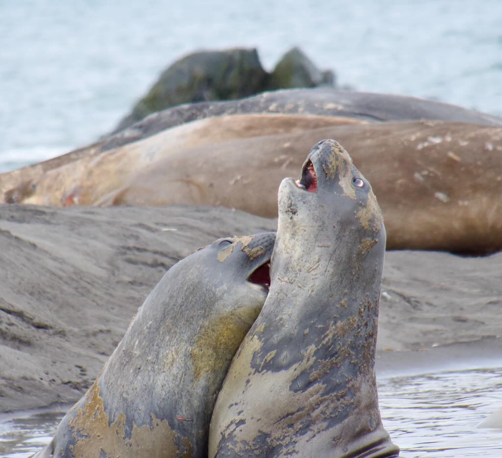
Adult male aggression
Dominance and polygyny
Elephant seals are among the most sexually dimorphic mammals, with adult males reaching up to 4,000 kg, whereas females rarely exceed 900 kg. This extreme size difference is the result of intense male-male competition for access to harems. The breeding season (typically from December to March for M. angustirostris and from August to October for M. leonina) is when aggression among males is at its peak.
Hierarchy establishment
Male elephant seals operate within a highly competitive, hierarchical system:
- Alpha Males (“Beachmasters“) – These are the dominant bulls that control harems of up to 100 females.
- Beta Males – Subordinates who may challenge the dominant male or attempt to sneak matings.
- Peripheral and Satellite Males – These lower-ranking males remain on the outskirts of the colony and usually do not breed.
Combat and threat displays
Dominance battles among males are some of the most brutal in the animal kingdom. These contests involve:
- Inflated Proboscis Displays – The characteristic enlarged nose of the male allows for deep, resonant bellows that establish dominance and deter rivals.
- Roaring Contests – Males bellow at each other in a vocal duel. Often, weaker males back down without engaging in physical fights.
- Chest-to-Chest Clashes – If vocal displays fail, males rear up and slam their upper bodies into one another.
- Biting and Wounding – Serious fights involve deep gashes, puncture wounds, and torn skin. Despite their thick blubber providing some protection, severe injuries can lead to death.
Fights can last from a few minutes to over an hour. The dominant male asserts control by physically overpowering his rival, who will eventually retreat.
The behaviour of losers
When a male loses a dominance battle, his actions depend on his status and the severity of the defeat:
- Submission – A losing male will often lower his head, retreat, and flatten his body to avoid further aggression.
- Peripheral Positioning – Defeated males may remain at the edges of the harem, waiting for another opportunity to challenge.
- Sneaky Mating Strategies – Some losers adopt a “sneaky” tactic, attempting to mate with females when the dominant male is distracted.
- Exile and Wandering – Severely beaten males may leave the breeding beach entirely, recovering in solitude before attempting to challenge again in the next season.
- Death – In some cases, males suffer fatal injuries from battle, particularly those inflicted on the throat and shoulders.
Older or permanently defeated males often abandon competition altogether, instead living in isolated areas or congregating with other non-breeding males.
Why did Elephant Seals become so large?
The extreme size dimorphism seen in elephant seals (males reaching up to 4,000 kg, while females rarely exceed 900 kg) is a result of both natural and sexual selection.
Deep-diving and energy efficiency
One of the main factors driving large body size was adaptation to deep-sea foraging:
- Large size reduces metabolic rate per unit of body mass, allowing for longer dives and greater energy storage in the form of blubber.
- Elephant seals routinely dive 500–1,500 meters deep in search of squid and fish, staying underwater for up to 2 hours.
This size advantage allowed them to exploit food sources unavailable to smaller marine mammals.
Sexual selection and competition
The enormous size of males is not just for survival. It is a direct consequence of intense competition for mates.
- Elephant seals evolved a polygynous mating system, where a single dominant male mates with dozens of females.
- Males that were larger, stronger, and more aggressive had higher reproductive success.
- Over millions of years, this led to runaway sexual selection, favouring massive body size and hyper-aggressive behavior.
Why are male Elephant Seals so aggressive?
The extreme aggression of elephant seals is primarily due to their reproductive strategy, which is based on male dominance and harem defense.
High-stakes reproduction
- Elephant seal males have one of the most skewed reproductive ratios in mammals.
- In a given breeding season, only a small percentage (~5%) of males will mate, while others never reproduce.
- Since mating success is monopolised by dominant “beachmaster” males, intense aggression and violent combat evolved as the primary means to secure reproductive opportunities.
The evolution of ritualised combat
Male aggression is not random. It follows highly ritualised patterns that evolved to minimise unnecessary injury while still enforcing dominance. This involves vocal threats, posturing and displays, bite-based battles, and loser submission.
These behaviors are the result of millions of years of selection pressure, where only the most aggressive, dominant males left offspring.
Aggression in females: a different evolutionary path
While male elephant seals are famous for their aggressive dominance battles, female elephant seals exhibit distinct social and aggressive behaviours of their own. Their comportment is shaped by factors such as breeding, pup-rearing, social hierarchy, and interactions with dominant males. Unlike males, female aggression is often centered on maternal investment and intra-sexual competition rather than mating access.
Social structure and hierarchy
Female elephant seals live in harems controlled by a dominant alpha male during the breeding season. However, within these harems, females have their own social hierarchy. Although not as violent as male interactions, female competition can be intense.
- Dominant Females (“High-Ranking”) – Older, more experienced females often have priority access to better pupping spots and show greater aggression toward lower-ranking females.
- Subordinate Females – Younger and smaller females occupy less favourable positions and are more likely to be displaced by dominant females.
- Peripheral Females – Some females remain on the edges of harems, sometimes to avoid male harassment.
Hierarchy among females is primarily determined by age, size, and prior breeding experience.
Aggressive behaviour among females
Although less dramatic than male-male fights, female elephant seals engage in aggressive encounters, particularly in high-density breeding environments.
Forms of female aggression
- Threat Displays – Females use open-mouth displays and vocalisations (high-pitched screams) to assert dominance or warn intruders.
- Biting and Body Shoving – Direct physical confrontations occur when females dispute space, often leading to superficial wounds.
- Maternal Aggression – Nursing mothers are particularly aggressive toward intruding females or threats to their pups.
Most aggression among females arises from competition over:
- Space in the Harem – Closer proximity to the centre provides more protection from the elements and dominant males.
- Pup Defense – Mothers actively fend off other females that come too close to their young.
- Food and Resting Sites (outside of breeding season) – While at sea, females are generally more solitary but may compete over resting spots.
Unlike male fights, female conflicts are usually short-lived, with the loser quickly retreating.
Mating and male interactions
Male harassment and avoidance strategies
- During the breeding season, females are often subjected to forced copulation by males, particularly lower-ranking ones who cannot secure a harem.
- To minimise harassment, females may use group positioning, staying close to dominant males for protection from sneaky males.
- Some females attempt to escape forced mating by moving toward the water, though this is rarely successful.
Estrus and mating Behaviour
- Females come into estrus about three weeks after giving birth.
- They generally have little control over mate choice, as the dominant male dictates breeding.
- If an alpha male is preoccupied, subordinate males may seize mating opportunities.
Maternal behaviour and pup rearing
Elephant seals have an extreme maternal strategy characterised by intense but short-term care.
Maternal investment
- Females give birth to a single pup per year (twins are rare).
- They nurse their pups for about 3–4 weeks, during which time they do not leave to feed, relying on stored fat reserves.
- During this period, they lose up to 40% of their body weight.
Maternal aggression
- Mothers aggressively protect their pups, lunging at intruding females or overzealous males.
- If an orphaned pup attempts to nurse from another mother, it is usually rejected aggressively.
- Occasionally, “supermothers” will adopt an abandoned pup, but this is rare.
Weaning and abandonment
- After the brief nursing period, the mother abruptly abandons the pup, leaving it to fend for itself.
- The weaned pup joins a “weaner group”, where it learns social behaviours through play-fighting and vocalisation.
Behaviour outside the breeding season
Unlike males, which spend months fasting and fighting for dominance, females spend most of their lives at sea.
- Solitary Deep-Diving Foraging – Female elephant seals travel vast distances to feed on squid and fish.
- Minimal Aggression at Sea – Unlike their breeding-season behavior, females generally avoid direct competition while at sea.
- Navigation and Site Fidelity – Many females return to the same breeding beach each year.
Competition for breeding space
- Harem areas are limited, and females must compete for prime pupping spots.
- Older, dominant females displace younger ones, leading to intra-female aggression.
Maternal investment and pup protection
- Since females only produce one pup per year, they evolved aggressive maternal instincts to protect their offspring.
- High female aggression toward intruding individuals ensures their pup has the best chance of survival.
Why didn’t other seals evolve the same way?
Elephant seals are unique in their combination of extreme size, deep-diving foraging, and highly aggressive mating systems. Other seals took different evolutionary paths based on their environments:
- Leopard Seals (Hydrurga leptonyx) evolved to be solitary apex predators.
- Weddell Seals (Leptonychotes weddellii) focus on cooperative group living.
- Harp Seals (Pagophilus groenlandicus) have a monogamous or promiscuous mating system, reducing male aggression.
Elephant seals’ evolution was driven by their need to monopolise resources and mates, leading to extreme aggression and size dimorphism.
This combination of evolutionary pressures resulted in the hyper-aggressive, hierarchical behaviour we see today. While it is an efficient strategy for reproductive success, it comes at a cost since most males never reproduce, and some die from fighting injuries.
Why do male Elephant Seals have a large, inflated nose?
The distinctive proboscis (enlarged, trunk-like nose) of male elephant seals is one of their most recognisable features. This exaggerated structure evolved through sexual selection and vocal communication as a key adaptation for dominance and reproductive success.
The proboscis as an evolutionary adaptation
The proboscis of male elephant seals evolved due to the species’ highly polygynous mating system, where a small number of dominant males control access to harems of females. This feature provides several evolutionary advantages related to aggression, communication, and mate competition.
Acoustic amplification for threat displays
One of the primary functions of the proboscis is vocal enhancement. The large nasal cavity allows males to produce deep, resonant bellows that serve as a threat display to rivals.
- These vocalisations are low-frequency sounds that travel long distances.
- A larger proboscis creates a deeper, more intimidating call.
- Roaring contests often determine which male retreats before physical combat occurs.
Why is this advantageous?
- Males save energy by scaring rivals away instead of fighting.
- Stronger, deeper calls signal larger body size, preventing unnecessary battles.
- Sound transmission is particularly effective in crowded, noisy breeding environments.
Visual signal of dominance
The proboscis is a secondary sexual characteristic, meaning it evolved due to female preference and male-male competition.
- A larger nose signals higher dominance rank among males.
- Younger or weaker males have smaller, less developed noses, making it clear who holds social power.
- This allows rapid assessment of rivals without immediate physical conflict.
How did the proboscis evolve?
The development of the elephant seal’s proboscis is an example of sexual selection through male competition, similar to the evolution of antlers in deer or the mane in lions.
Sexual selection and runaway trait development
- Early elephant seal ancestors likely had smaller nasal structures.
- Over generations, males with larger, louder noses outcompeted others for mates.
- Females indirectly favoured dominant males, reinforcing the evolution of larger noses and deeper vocalizations.
This is an example of runaway selection, where a trait becomes exaggerated over evolutionary time because it gives an advantage in reproduction.
Hormonal influence on growth
- The proboscis only develops fully in sexually mature males (~3–5 years old).
- It grows in response to testosterone during the breeding season.
- Older males have more pronounced noses, further reinforcing social rank.
Why don’t females have large noses?
Female elephant seals do not engage in male-male combat or harem defence, so they did not evolve an enlarged proboscis.
- Female selection pressures favour smaller, more streamlined bodies for deep diving and energy conservation.
- Since they do not need to produce loud, long-distance calls, there was no evolutionary benefit to developing a large proboscis.
Do any other animals have similar adaptations?
Yes! Several species evolved nasal structures for dominance and communication, including:
- Proboscis monkeys (Nasalis larvatus) – Males have large noses that amplify vocalisations and attract mates.
- Walruses (Odobenus rosmarus) – Use deep bellows and tusks for male-male combat.
- Moose (Alces alces) – Have nasal chambers that help in vocalising during the rut.
- Saiga antelope (Saiga tatarica) – Have an enlarged nose that acts as a sound filter and temperature regulator.
These examples highlight convergent evolution, where different species develop similar traits for dominance and communication.
Can You Tell the Difference Between a Young Female Elephant Seal and an Young Female Antarctic Fur Seal?
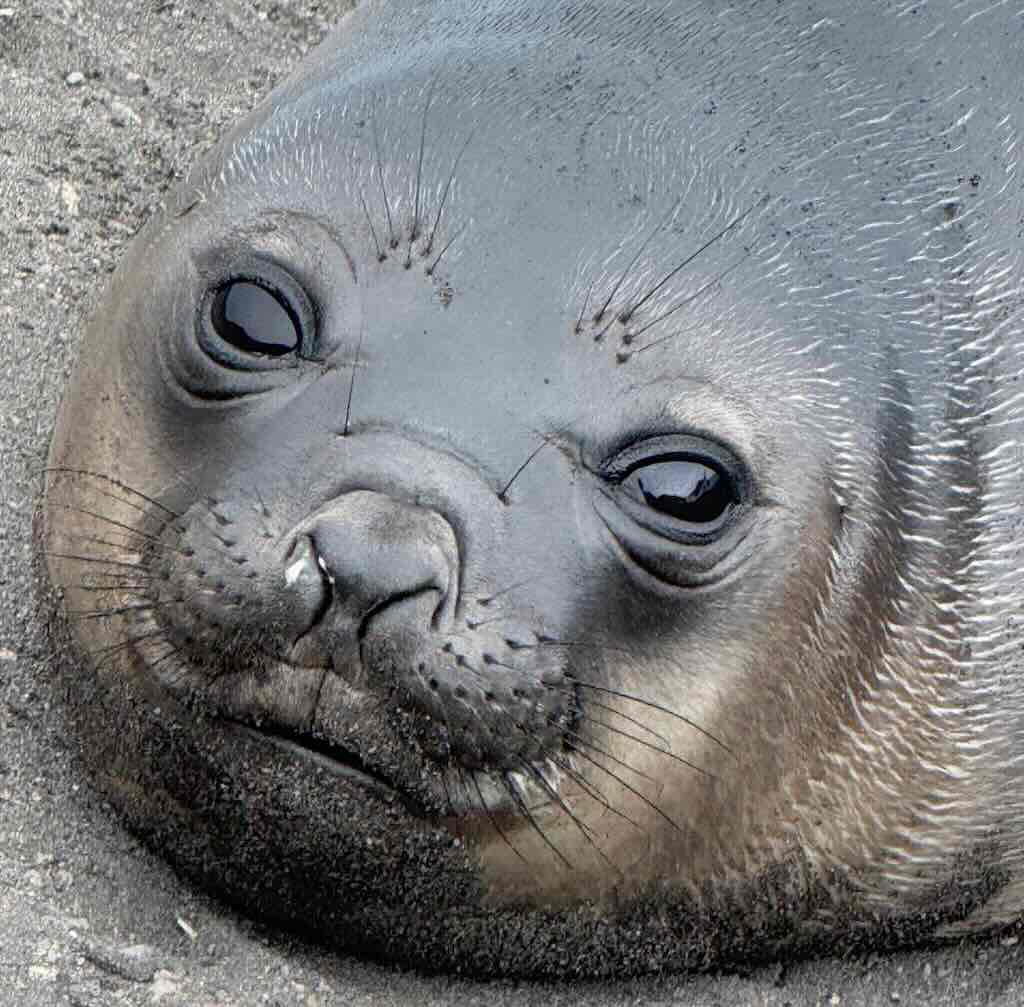
The question is ‘easy’. Is the above photo of a young female elephant seal or a young female antarctic fur seal? It might have helped if we could see her size and body shape, but it can be quite tricky to tell the different if they are some distance away.
Body shape and size
Young female Elephant Seal (Mirounga leonina):
- Large, robust, and bulky with a thick, blubbery body.
- More streamlined, torpedo-like when seen from above.
- Shorter flippers relative to body size.
- Even young females tend to be much larger than Antarctic fur seals.
Female Antarctic Fur Seal (Arctocephalus gazella):
- Much smaller and more agile in appearance.
- Slender, more “dog-like” body with a defined neck.
- Long, prominent flippers that they use to move on land with agility.
Fur and skin texture
Elephant Seal:
- Short, coarse hair that appears smooth when wet.
- When dry, skin can look rough and wrinkled, especially on older individuals.
- Lacks external ears.
Antarctic Fur Seal:
- Thick, dense fur that appears soft and often has a slight golden sheen when dry.
- A noticeable contrast between wet (sleek) and dry (fluffy) fur.
- Has visible external ears.
Head and facial features
Elephant Seal:
- Blunt, broad snout with large, wide-set nostrils.
- Small eyes compared to head size.
- No external ear flaps.
Antarctic Fur Seal:
- More pointed snout, almost dog-like.
- Large, round, expressive eyes.
- Small but visible external ear flaps.
Movement on land
Elephant Seal:
- Moves by undulating its body in a worm-like fashion.
- Not very agile on land.
Antarctic Fur Seal:
- Moves more like a sea lion, using its flippers to “walk” with ease.
- More nimble and fast on land compared to an elephant seal.
Behaviour and habitat preferences
Elephant Seal:
- Usually more sluggish on land.
- Tends to be found resting in large, dense groups on beaches.
- Rarely aggressive unless provoked.
Antarctic Fur Seal:
- More active and can be aggressive, especially females defending their territory or pups.
- Often found in looser colonies, with some individuals wandering inland.
Size differences in context
- A young female elephant seal may still be larger than an adult female Antarctic fur seal.
- Adult female elephant seals range 400–900 kg, whereas Antarctic fur seal females only weigh 25–50 kg.
So what do you think?
Both species have vibrissae (whiskers) around the nose and mouth, but their whiskers differ in appearance, length, and prominence.
The elephant seal’s whiskers are relatively short and sparse compared to fur seals, and they are thicker and straighter (and don’t curl).
The fur seal’s whiskers are longer, more numerous, and prominent, and can be curved or slightly wavy. They are also more noticeable due to the contrast with the smaller, pointed snout.
Maybe the ‘eyes’ have it. A young Antarctic fur seal has larger, more prominent eyes relative to its head, giving it a more ‘cute’ or wide-eyed appearance. This is an adaptation for hunting in dim underwater conditions. A young elephant seal also has large eyes, but they appear smaller relative to its larger head and thick face. They look less protruding than in fur seals.
Fur seals have more forward-facing eyes and a more compact skull, making their gaze appear more direct and otter-like. Elephant seals have eyes positioned more to the sides, due to their larger, much wider facial structure.
In both species, the eyes are large and dark, almost black, adapted for underwater vision. However, fur seals often have a glossier, more reflective surface, making their eyes appear shinier and more expressive. Elephant seals may have slightly duller-looking eyes by comparison, though they still have excellent low-light vision.
Both have round pupils that dilate significantly in the dark, but elephant seals, which dive far deeper than fur seals, have even more extreme pupil dilation capabilities.
But the key question, if you are close enough, is simply “does the young female seal have ears”?
So the photo above is of a young female elephant seal.
In fact, the ears of a young Antarctic Fur Seal and a young Elephant Seal are one of the most immediately noticeable differences between them. The Fur Seal has visible external ear flaps (pinnae), which are small but distinct. And they stick out slightly behind the eyes, giving them a more “dog-like” or “otter-like” appearance. The Southern Elephant Seal has no visible external ear flaps. Instead, the ears are just small openings on the sides of the head, making their heads appear smoother and more streamlined, a crucial adaptation for deep diving. For the Fur Seal the external ears help with above-water hearing and communication, especially since they spend more time on land. And for the Elephant Seal, the absence of external ear flaps reduces drag in the water, making them more hydrodynamic for deep diving.
On top of that, it worth remembering that Elephant Seals prefer open beaches with gentle sloping sand or gravel. Whereas Antarctic Fur Seals prefer rocky shorelines, tussock-covered terrain, or slightly elevated areas near beaches, in part because they are more agile and can climb over rocks or into grassier areas.
How Did Antarctic Fur Seals Evolve, Survive, and Thrive?
The divergence between the lineage that led to Antarctic fur seals (Arctocephalus gazella) and the “earless” true seals (Phocidae) is a story of evolutionary change that took millions of years to tell.
In essence, about 15–20 million years ago, during the Miocene epoch (23 to 5.3 million years ago), environmental changes and the emergence of new ecological niches prompted a key evolutionary split among Pinnipeds. These are marine mammals with flippers, and it includes 34 extant species and more than 50 extinct species of seals. The ancestors of Antarctic fur seals, part of the Otariid group (Eared Seals such as sea lions and fur seals), developed features, like external ears and agile fore-flippers, that allowed them to exploit both land and sea. While the precise geographic pinpointing is complex, evidence supports an origin in the North Pacific followed by a southward expansion into the rich, yet challenging, environments of the Southern Ocean.
Changes in oceanic conditions and the emergence of new coastal and nearshore habitats led to different selective pressures. Otariids (Eared Seals), the ancestors of fur seals, evolved external ear flaps, which improved their hearing and helped with land mobility, an advantage for breeding on rocky or island shores. They developed more agile fore-flippers, making them better swimmers and more adept at manoeuvring between land and water. In contrast, the true seals (Phocidae) evolved a more streamlined, earless form that was highly specialised for an aquatic lifestyle, often favouring open-water foraging over terrestrial breeding sites.
As these early Otariids spread out from the North Pacific, some populations moved into the Southern Hemisphere. In the Southern Ocean, new environmental conditions and ecological niches provided the stage for further adaptations, leading eventually to the evolution of species such as the Antarctic fur seal. The combination of a cooler climate, shifting ocean currents, nutrient-rich waters, and the emergence of isolated, predator-free subantarctic islands likely influenced where and how these adaptations took hold.
The fur seals dense, dual-layered pelage, with a thick underfur (down hair) for insulation and longer, coarser guard hairs, was critical for survival in frigid waters and was historically prized for its quality.
Equipped with strong, flexible flippers and external ear flaps, these seals evolved for both agile swimming and effective movement on land.
Males are significantly larger than females (sexual dimorphism), a trait that supports both physical confrontations during breeding and visual signalling. Mature males exhibit robust bodies, enlarged fore-flippers, and sometimes a mane-like appearance around the neck, which aids in both thermal regulation and visual signalling during breeding displays. Dominant males control harems of females. Breeding displays include vocalisations, physical posturing, and sometimes aggressive encounters among rival males. Females typically return to the same breeding sites annually to give birth and nurse their pups. The timing of reproduction is closely linked to environmental conditions and prey availability.
Antarctic fur seals form large, gregarious breeding colonies on remote, predator-free islands. Their ability to dive deeply and adjust foraging patterns seasonally allowed them to exploit diverse marine resources, from fish to squid, across vast areas of the Southern Ocean. While many individuals remain relatively close to their breeding colonies, seasonal migrations are common. These movements are influenced by the search for food and optimal foraging conditions, which can vary with ocean currents and prey distribution.
In the late 18th and 19th centuries, fur seals were hunted extensively for their luxurious underfur and valuable blubber. This unsustainable exploitation led to dramatic population declines and the near-extirpation of some colonies. The severe depletion initiated some of the earliest conservation measures. With the advent of international agreements and modern wildlife management practices, many populations have shown impressive recovery.
Modern estimates suggest that Antarctic fur seals now number around 4 million individuals globally. The largest breeding colony, located on South Georgia, alone supports between 3 to 4 million seals during peak breeding seasons.
There are other types of seals that share the Antarctic ecosystem.
Crabeater Seal (Lobodon carcinophaga) – Estimated at 7–8 million individuals, they the most abundant Antarctic seal. Circumpolar distributed on pack ice, they feed predominantly on krill.
Weddell Seal (Leptonychotes weddellii) – With a population of around 800,000, they inhabit coastal fast ice, and are noted for their deep diving capabilities.
Leopard Seal (Hydrurga leptonyx) – With a population of approximately 100,000, they are found in both pack ice and open waters, and are recognised as apex predators.
Ross Seal (Ommatophoca rossii) – With a population estimated in the tens of thousands, they are quite elusive, dwelling within remote pack ice regions.
Southern Elephant Seal (Mirounga leonina) – With a population of roughly 600,000–650,000, they breed on both subantarctic and Antarctic islands, and are known for their massive size and long migrations.
Who hunted seals and why?
In the early 19th century, seal hunting on Livingston Island, part of the South Shetland Islands, was a significant industry driven by the high demand for seal skins in global markets. The primary consumers of these pelts were fashion industries in Europe and the United States, where seal fur was prized for its warmth and durability, making it ideal for coats, hats, and other garments. Advancements in processing techniques, such as Thomas Chapman’s 1796 method for separating fur from guard hairs, enhanced the quality and appeal of seal products, further increasing their market value. His name was given to Chapman Rocks on the north side of Livingston Island.
The sealers, predominantly from Britain and the United States, processed the seals on-site. After hunting, they removed the pelts and blubber, often salting the skins to preserve them for transport. This immediate processing was crucial to prevent spoilage during the long voyages back to commercial centres.
The discovery of the South Shetland Islands in 1819 by British mariner William Smith opened new opportunities for sealers. In the 1819/20 season, at least one American and two British vessels operated in the South Shetland Islands, collectively harvesting tens of thousands of fur seal skins. The following season, 67 sealing ships were present, but by 1822/23, the number had dwindled to 10, and continued to decrease in subsequent years. It’s reported that William Smith alone had taken 60,000 seal skins during this period. The island’s population swelled to over 200 individuals between 1820 and 1823, primarily due to the sealing rush. Sealers established temporary settlements, constructing stone huts and utilising natural caves for shelter. Archaeological research has identified 26 human-built shelter structures on Byers Peninsula alone.
Seal pelts were highly valued for their fur, and in the early 19th century, the primary markets for these pelts were in Europe and the United States. Merchants and fashion houses sought high-quality seal skins to meet the demands of affluent customers. The pelts were shipped from sealing hubs like Livingston Island to processing centres, where they were tanned and fashioned into luxury items.
Who was Thomas Chapman and What Did He Do?
I’m going to digress a little and tell the story of Thomas Chapman, mentioned above in the context of seal skins.
Mr. Chapman worked as trunk maker and exercised his trade for some years in New Long Lane Southwark, South London, England. It would appear that he was reasonable successful. In the course of his business in the year 1795 he purchased some skins for covering trunks, and he observed that under the coarse bristly hair there was a silky wool almost as fine as Beaver wool (felt hats made with this wool were expensive status symbols in Europe). He learned that these skins came from Southern Whalers and that hatters were well aware of the value of this silky quality wool. But no one had yet found the way to separate this silky wool from the coarse bristly hair.
Mr Chapman immediately began to experiment, and meeting with some success, he neglected his original business so entirely, that when he succeeded in 1795 by completely separating the wool from the hair, he had no money enough to pay the expense of a patent.
He set to work however with diligence in his new vocation and found an “abundance of custom” from the hatters. He soon began to make money, but as he had been obliged to reveal the secret of his process to his workmen, he was now advised that he could no longer take out a patent, because the technique had become “common knowledge” and was no longer new.
In 1798 the price of seal skins was less than 2 shillings each, irrespective of their origin. Southern whale fishers were little inclined to bring their skins all the ways back to English, but Mr Chapman managed to convince one merchant to sail to ‘New Georgia’ by offering 3 shilling 6 pence for small & middling skins and 6 shillings for very large ones. Fifteen months later the ship returned and with the profits Mr Chapman able to build and fit-up his factory.
His success now attracted the attention of other traders who possessed the capital that Mr Chapman sadly lacked. They enticed away the workmen he has instructed, and were able to set up rival manufactories.
His method involved pulling the fur from the skin instead of cutting it. After removing the bristly hairs he obtained from each skin a larger quantity of high quality wool at a smaller expense then he could do by cutting, He should have kept his invention a secret and taken out a patent. For want of legal protection to secure his original invention “he was most grievously disappointed, the whole of the wool obtained by this new process was returned upon his head by his customers”. Mr Chapman has laboured for years and had the mortification to see his moneyed neighbours grow rich in the trade he himself originally invented, and in which they supplanted him while he lived on the hourly fear of bankruptcy, scarcely able to keep his family from want”. He has seen the South Whalers who had almost abandoned the sealing business receive upwards of £200,000 in consequence. Because of his discovery he has seen the middling seal skins which he originally purchase for 2 to 3 shillings each rise to the value of from 13 to 14 shillings and the large ones worth from 20 to 30 shillings. He believed that in a 9 year period more than 40,000 lb. of seal furs were prepared by his process annually. Allowing one ounce for each hat, this must have covered 4,480,000 sheep-wool bodies. Bodies not worth more than 2 shillings each, but converted into fine examples worth from 10 to 16, 18, or even 20 shillings. Remembering that Beaver skin cost 4 to 6 guineas a pound (80 to 120 shillings/pound) whilst seal furs cost from 30 to 50 shillings.
At the time of writing (1806) the art of the separating the seals fur from the hair was solely in the hands of the British manufacturer and only carried on in London. However, the Chinese were said to have possessed it from ancient times and “this was probably the case as they gave an advanced price for the skins of the fur seal, but the art of making hats was not practised by that nation”.
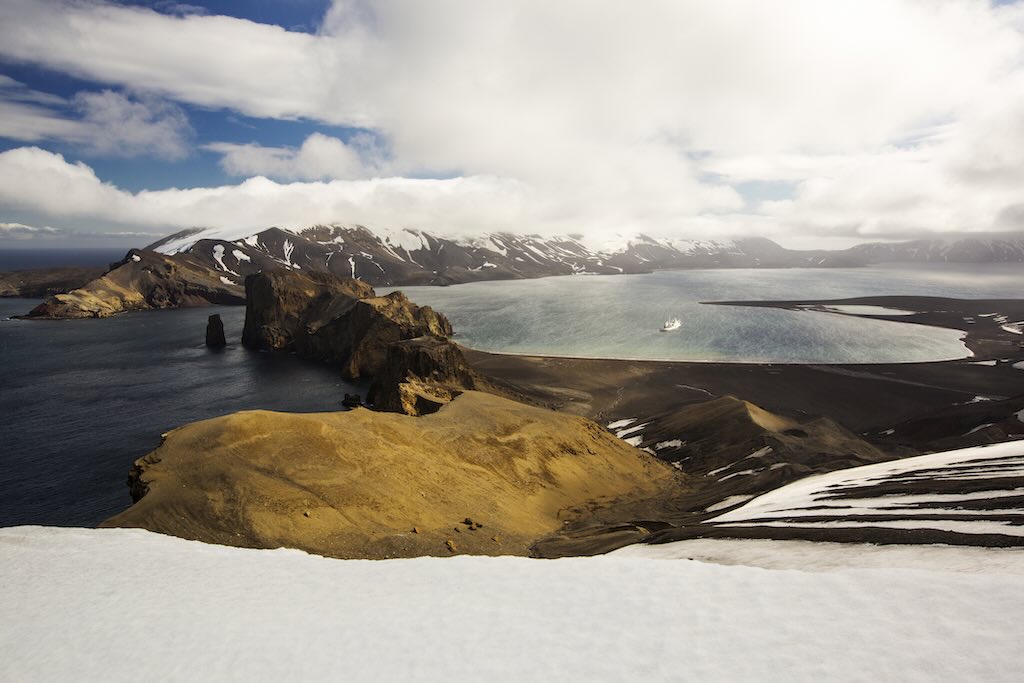
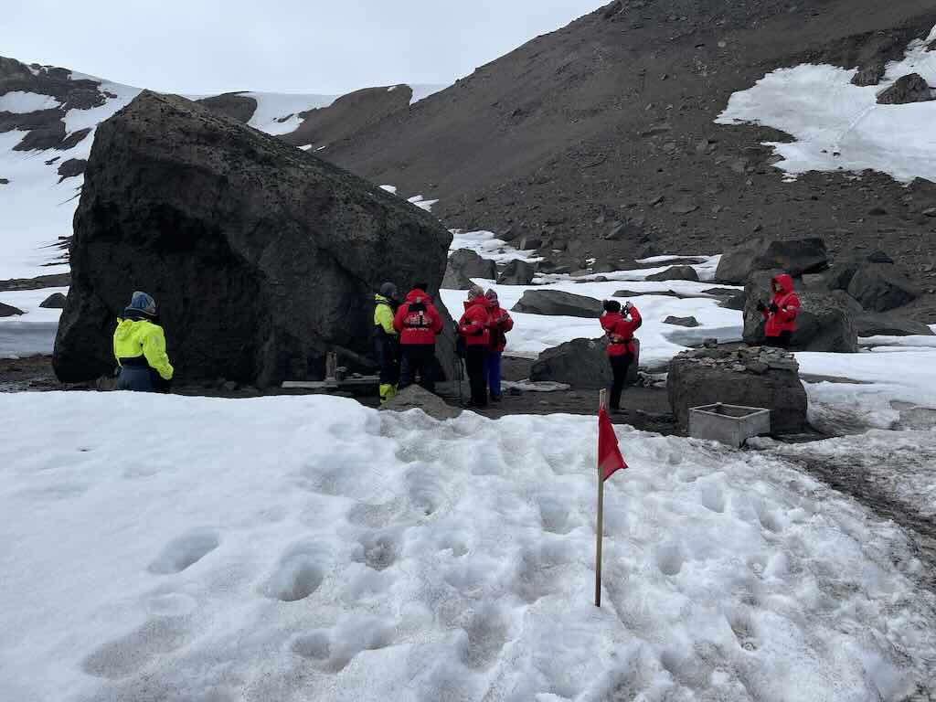
Excursion - Telefon Bay
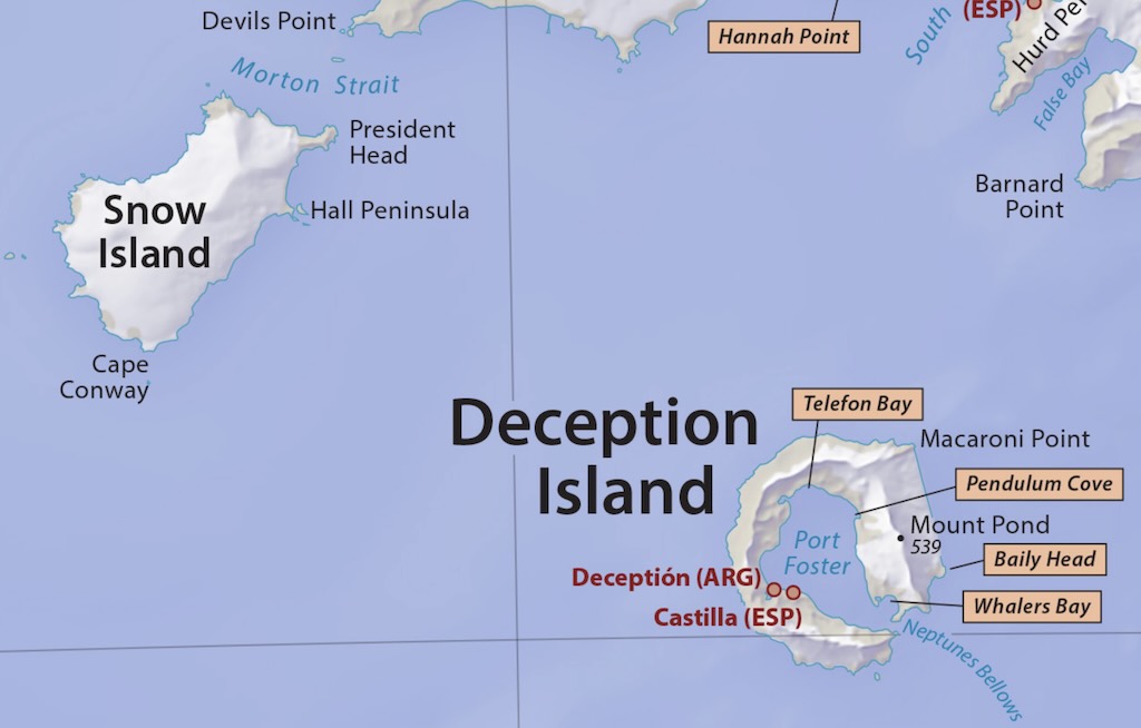
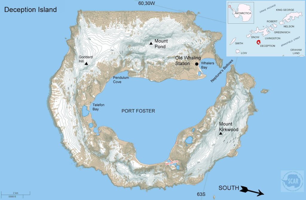
Telefon Bay is a coastal bay and volcanic crater complex located within Port Foster, the flooded caldera of Deception Island.
Deception Island itself is a horseshoe-shaped volcanic island, one of the most remarkable and geologically active locations in Antarctica. It is part of the Bransfield Basin, a back-arc rift zone associated with the subduction of the Antarctic Plate beneath the South Shetland microplate.
There is an excellent one-page scientific-style poster called “Deception Island (South Shetland Islands, Antarctica)“, which can be downloaded from https://digital.csic.es/handle/10261/162691.
Telefon Bay lies along the northwestern shore of Port Foster, an extensive natural harbour formed by the collapse of the island’s central volcano. The bay consists of multiple volcanic craters, lava flows, and ash-covered terrain, shaped by eruptions that occurred during the 20th century (1967 and 1970). This makes Telefon Bay one of the youngest volcanic landscapes in Antarctica.
It is a barren, lunar-like landscape devoid of significant vegetation, which is a striking visual contrast to the ice-covered surroundings. There are steep crater rims and ridges, which offer panoramic views over both Port Foster and Deception Island.
Deception Island, including Telefon Bay, is classified as Antarctic Specially Managed Area (ASMA 4 out of a total of 7) due to its scientific importance. Scientists study thermal anomalies, volcanic gases, and subsurface heat flow in the bay to monitor ongoing volcanic activity. And the landscape is used for planetary research, as the ash-covered terrain and craters resemble volcanic regions on Mars and the Moon.
Deception Island has a long history of whaling, sealing, and scientific exploration, with remnants of human activity scattered across the island.
Telefon Bay was named after the Norwegian whaling vessel Telefon, which operated in the region during the early 20th century. The ship was one of many that took advantage of Deception Island’s natural harbour for whaling operations, which thrived from the early 1900s to the 1930s.
Deception Island itself was first discovered by British sealers in 1820, and its unique volcanic nature was recognised in the 19th century. However, the specific naming of Telefon Bay likely occurred during whaling operations in the early 20th century, when Norwegian whalers frequently used the caldera as a safe harbour.
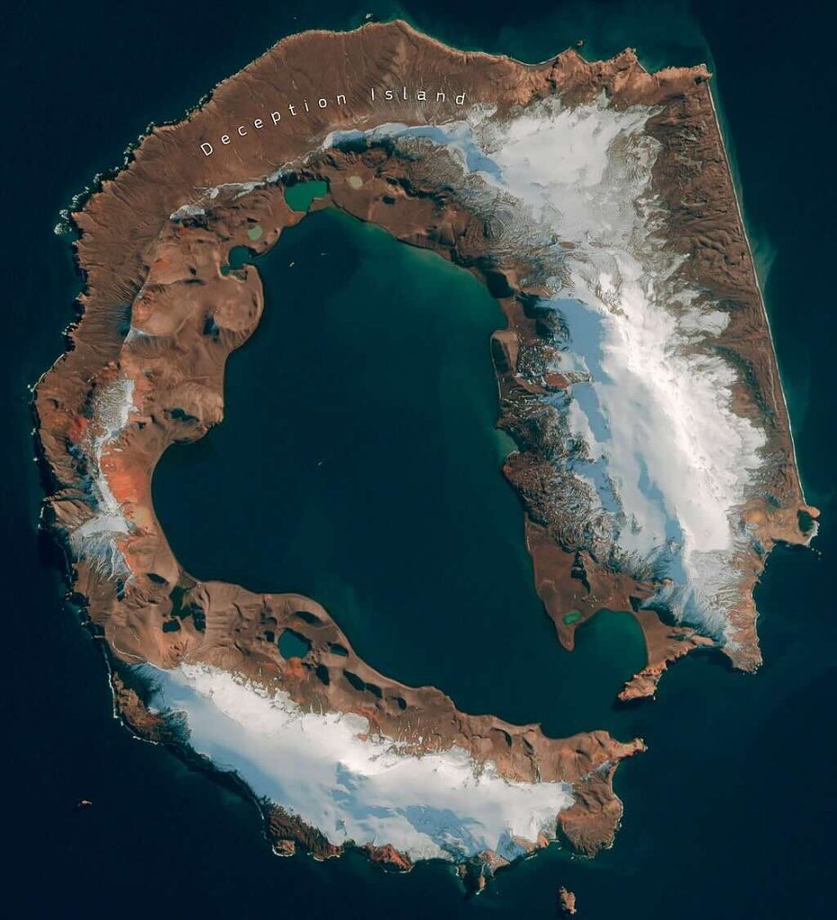
Above we have a rare cloudless view of the island, as seen on the Wikipedia entry. But why is there a nearly straight-line feature on one side?
The reality is that Deception Island is a product of its tectonic and volcanic history. This side corresponds to a fault line, a structural weakness where the caldera’s formation and later collapse influenced the island’s shape. Here’s why this happened:
Caldera Formation & Collapse:
- Deception Island is a volcanic caldera, meaning it formed when the volcano’s summit collapsed after a massive eruption. The collapse wasn’t perfectly symmetrical, as certain sections caved in more dramatically than others.
Tectonic Control from the Bransfield Rift:
- The island lies within the Bransfield Strait, an active rift zone where the Antarctic Plate interacts with the Scotia Plate. The Bransfield Rift System pulls the region apart, creating structural weaknesses that likely controlled the caldera’s shape.
- One side of the island aligns with these deep-seated faults, which led to a more linear collapse rather than a perfectly circular one.
Erosion and Glacial Influence:
- Over thousands of years, erosion and ice sheet movements helped reinforce the linear coastline, maintaining the straight-line effect on one side.
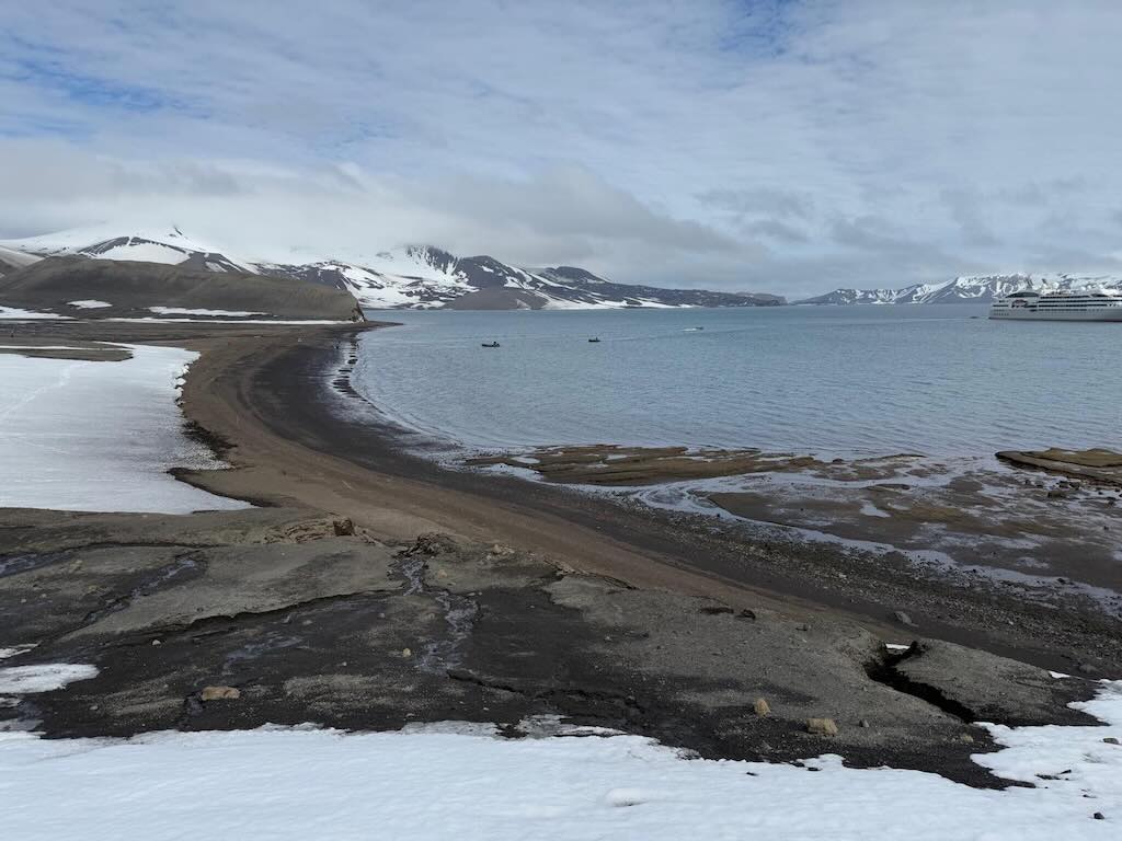
I still vividly remember watching as we sailed out of the volcanic caldera of Deception Island. Franky, I had not noticed our entry into the caldera, but I remember watching intently as we sailed out to the open sea.

The almost enclosed lagoon-like harbour is known as Port Foster, and the only entrance is through Neptune’s Bellows, a narrow, hazardous channel with strong currents, submerged rocks, and shifting volcanic sediment.
Port Foster was named after Henry Foster, captain of HMS Chanticleer and leader of the first scientific expedition to the island in 1829. The expedition, based in Pendulum Cove, made gravitational and magnetic measurements, produced the first topographic map, made temperature measurements, and made a hydrographic survey.
“Neptune’s Bellows” refers to the Roman god of the sea, and the evocative ‘bellows’ because of the strong, funnelling winds that can often exceeding 40 knots in gusts.
In the above photo the entrance might look reasonable wide, but, as the name “Deception” suggests, it’s deceiving.
The depth inside Port Foster varies between 5 and 180 meters, and is around 35–50 meters near the shores (in Telefon Bay it’s ~20 meters). The entrance width at Neptune’s Bellows is ~230 meters, but the navigable width is only ~100 meters. The depth at the entrance can be a little as ~13 meters at the shallowest. And there is an underwater pinnacle called “Raven Rock” at ~2.5 meters under the surface at low tide. The rule is to pass, leaving it at least 50 meters.
Given that the island is an active volcano with geothermal seabed heating, the advice is to always monitor VHF Channel 16 (universal maritime distress, safety, and calling frequency) and contact Antarctic Treaty operators if necessary. IAATO (International Association of Antarctica Tour Operators) guidelines apply.
In the video we can see a small rock outcrop near the rock wall. It’s called “Seward Rock” and sits approximately 30 meters offshore from the eastern rock wall at the narrowest part of Neptune’s Bellows. It actually acts as a natural marker for ships aligning their route through ‘bellows’. And it helps them keep clear of the submerged Raven Rock on the western side.
Seward Rock is named after William H. Seward (1801–1872), the U.S. Secretary of State who negotiated the purchase of Alaska from Russia in 1867. It is unclear exactly when the rock was named, but it follows a tradition of naming Antarctic features after notable political figures involved in exploration or territorial expansion. The name likely reflects early American or whaling-era connections with Antarctic exploration.
At 18:15 there was a daily recap & briefing, about what had happened during the day, and what was planned for the next day.
What's so Alien about Deception?
Deception Island has been identified as a promising terrestrial analogue for Mars, offering valuable insights for astrobiological research. The island’s unique combination of geological and environmental features closely mirrors conditions found on Mars, making it an ideal site for studying potential Martian habitats and testing exploration technologies.
Geological features:
Volcanic Activity: Deception Island is an active volcano with a history of eruptions, resulting in diverse geological formations such as calderas, lava flows, and tephra deposits. These features are analogous to volcanic regions on Mars, providing a natural laboratory to study volcanic processes and their potential to support life.
Hydrothermal Systems: The island hosts hydrothermal vents and fumaroles, environments where microbial life thrives despite extreme conditions. These systems are comparable to hypothesised hydrothermal environments on ancient Mars, offering insights into possible habitats for past Martian life.
Permafrost and Glaciovolcanism: The interaction between volcanic activity and glacial ice on Deception Island leads to unique glaciovolcanic features. Studying these formations enhances our understanding of similar processes that may have occurred on Mars, especially concerning the stability of liquid water and potential habitats in permafrost regions.
Environmental conditions:
Extreme Cold and Dryness: The island’s harsh climate, characterized by low temperatures and arid conditions, parallels the Martian environment. This similarity allows researchers to investigate how life can adapt and survive in such extreme settings, informing the search for life on Mars.
Presence of Perchlorates: Soil analyses on Deception Island have detected perchlorates, salts also found on the Martian surface. Studying these compounds in Earth’s environment helps assess their impact on potential life and informs the design of life-detection experiments for Mars missions.
Astrobiological significance:
Extremophiles: The island’s extreme environments harbor microbial life forms known as extremophiles. Investigating these organisms enhances our understanding of life’s resilience and guides the search for biosignatures on Mars.
Biosignature Preservation: The unique conditions on Deception Island contribute to preserve biosignatures. Studying these preservation mechanisms aids in developing strategies to detect signs of past or present life on Mars.
Engineering applications:
- Testing Ground for Technologies: The island’s Mars-like conditions provide an excellent venue for testing exploration technologies, including rovers, drilling equipment, and life-detection instruments. Conducting field tests in such an environment ensures that these technologies are well-adapted for future Martian missions.
In summary, Deception Island serves as a multifunctional Martian analogue, offering a unique combination of geological and environmental features that are invaluable for astrobiological research and the development of exploration technologies.
I am a mountain of fire, a sentinel of ice. My name is Deception, but I have never deceived. I have roared, I have bled, and I have reshaped the face of this world with my breath. I was born not in a moment, but in the slow heaving of Earth’s molten heart. My lineage is ancient, a whispered memory of the planet’s infancy, and my life is measured not in human years, but in the grinding of continents, the shifting of tectonic plates, and the violent birth of islands.
Once, I was hidden beneath the Southern Ocean, unseen but not silent. My fire churned beneath the waves, a secret inferno sculpting rock from the void. Then, some ten million years ago, I breached the surface. The water hissed and turned to steam as I exhaled my first breath into the sky. Lava spilled forth, hardened, and built upon itself, raising me from the ocean floor, a growing wound in the skin of the world. My peak once towered over 500 meters above sea level, and my total diameter reached 15 kilometers. My submerged roots extend even deeper, anchoring me into the lithosphere with an estimated mass of over 100 billion metric tons.
But the heart of a volcano is never at peace.
One day, I shattered. My summit collapsed into the great empty chamber within me, forming a caldera, a scar, a memory of my own destruction. The sea rushed in, filling my wound, creating a great bay spanning over 9 kilometers across. The sailors who came later thought me a sanctuary, a safe harbour from the fury of Antarctic storms. They did not know I was only resting, gathering my strength, waiting.
And so they named me Deception. They saw my flooded caldera, my tranquil waters, and believed I was a place of refuge. But I have never been a refuge. My heart burns as hot as any fire in the Earth’s core. My name is a trick played by those who do not understand the nature of a volcano. Would I have chosen another name? Perhaps. A name of power, one that speaks of my force, my ability to shape and destroy. But names are given, not chosen. And so I carry Deception, wearing it like a mask, watching as men still misunderstand what I truly am.
Through the centuries, I watched as life touched my shores. Penguins nesting on my ashen slopes, seals basking upon my black sandy beaches, humans daring to build upon my bones. Whalers arrived first, carving their industry into my coastline, staining my waters with the fat and blood of leviathans. They anchored their ships within my flooded heart, never realising they stood upon a slumbering beast. Later came the explorers and the scientists, those who sought knowledge rather than conquest, planting their fragile stations upon my shores, probing my secrets.
I warned them.
In 1967, I stirred. The ground trembled, steam burst from the earth, and my long-silent voice growled once more. My surface temperature, normally resting near freezing, surged as boiling fumaroles reached 100°C, melting ice and releasing clouds of sulfurous gas. A warning, but it was not heeded.
In 1969, I spoke louder. My wrath came in the form of an eruption, a flood of molten rock and pyroclastic fury that swept away the structures built upon me. Ash rose more than 10 kilometers into the air, carried by Antarctic winds, forming a thick plume that darkened the sky. The ejected material was scalding, reaching temperatures exceeding 800°C at the moment of eruption, but it cooled rapidly as it ascended, turning into a choking blanket of fine volcanic dust.
The finest particles remained suspended in the atmosphere for weeks, carried by the high-altitude jet streams, drifting thousands of kilometers before finally settling. Larger, heavier ash fell back upon my slopes within hours, blanketing my landscape in gray, mingling with the ice and staining it dark. New lava flows covered over two square kilometres of my surface, reshaping my terrain, sealing off old paths, and creating new fissures. The human presence, so stubborn, was forced to retreat, abandoning their stations to the ash and fire. And yet, they returned, drawn by the paradox of my existence. I am an island of fire in a land of ice, a place where steam and snow dance together in an endless cycle.
Now, I watch. I slumber, but I do not sleep. Beneath my black sands, beneath the frigid waters of my caldera, my fire still moves. My magma chamber, resting less than 5 kilometers below the surface, pulses with temperatures exceeding 1,000°C. The magma beneath me shifts and swells, pressing upward, seeking release. Scientists still come, measuring my breath, taking my pulse, seeking to understand when I will rise again. They place sensors upon my skin, listen to my subterranean heartbeat, and yet, they do not know when I will awaken.
But I know. I feel the pressure building, the heat gathering in the deep. One day, I will rise again, and the world will remember that Deception is not a lie. I am the truth of this Earth, the reminder that nothing is ever truly at rest, that even in the coldest places, fire still burns.
I am Deception. I have not finished my story.
8 December 2024 - Wilhelmina Bay and Danco Island (Day 13)
Calm night, woke around 04:30 local time.
Temperature 1-2°C and a 4-11km/h wind during the day.
Sunrise was at 02:38 and sunset at 23:24.
The day started with breakfast at 07:00.
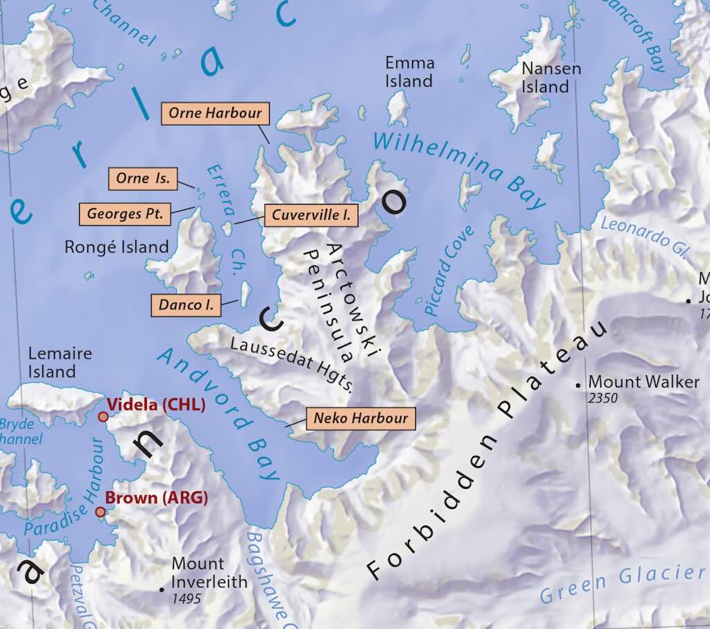
Excursion - Wilhelmina Bay
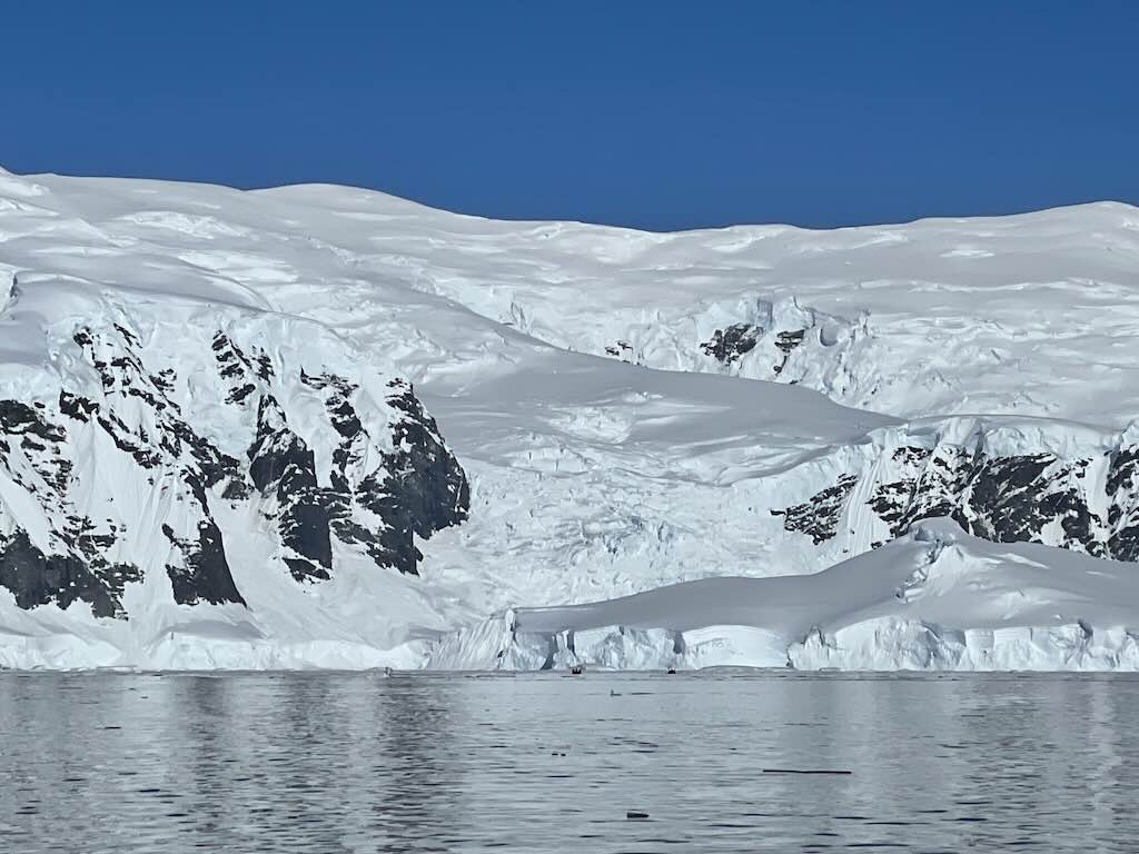
Wilhelmina Bay is a large, glacially-carved bay located along the western coast of the Antarctic Peninsula, specifically on the Danco Coast of Graham Land (opening into the Gerlache Strait). The bay is roughly 24 km wide and surrounded by towering, snow-covered peaks and extensive ice formations.
This region is part of the larger Bellingshausen Sea, which experiences seasonal sea ice but remains accessible to ships during the Antarctic summer (November to March).
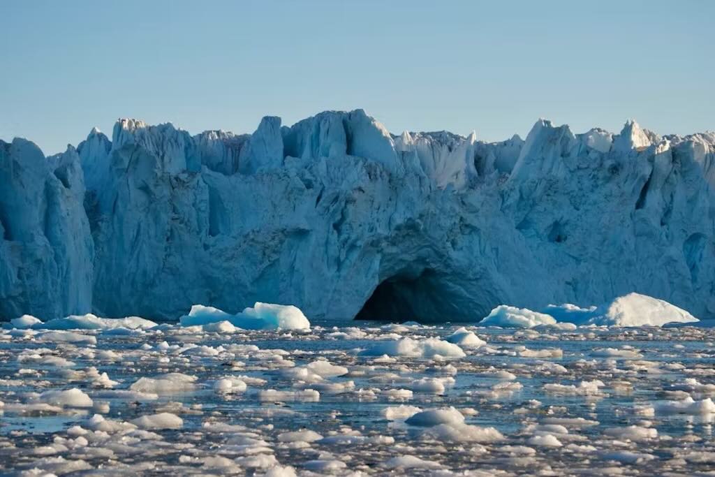
Wilhelmina Bay is a deep, fjord-like glacial bay, formed by the erosion of massive ice sheets that once extended further into the Southern Ocean. The bay has steep ice cliffs and massive tidewater glaciers that frequently calve icebergs into the bay. Deep waters, allowing large ships to navigate relatively close to shore, and its protected, so a safe anchorage for vessels despite the presence of drifting ice.
Wilhelmina Bay has been nicknamed “Whale-mina Bay” because of its high population of Humpback Whales (Megaptera novaeangliae) that feed in the krill-rich waters during the summer months. Other marine mammals, including Minke whales, Orcas (killer whales), Weddell seals, Crabeater seals, and Leopard seals, are commonly observed.
Gigantic tidewater glaciers, such as the Trooz Glacier, constantly calve icebergs into the bay, creating a dynamic landscape.
Wilhelmina Bay was discovered and charted by the Belgian Antarctic Expedition of 1897–1899, led by Adrien de Gerlache de Gomery aboard the ship RV Belgica. This expedition was the first to spend an entire winter trapped in Antarctic sea ice, leading to groundbreaking discoveries about polar conditions.
The bay was named in honour of Wilhelmina, Queen of the Netherlands (1880–1962), who had recently ascended to the Dutch throne in 1890 at the age of ten. The Belgian expedition, which relied on European funding and support, named various Antarctic features after royalty and prominent figures of the time.
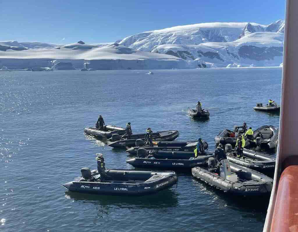
This mornings excursion was a zodiac trip around the bay. From what I remember, there was no possibility to land.
Above we can see the zodiacs being lowered into the water from the store on the top deck. Each morning and evening, the 11 zodiacs were lower from the top deck, and in the evening stored back on the top deck.

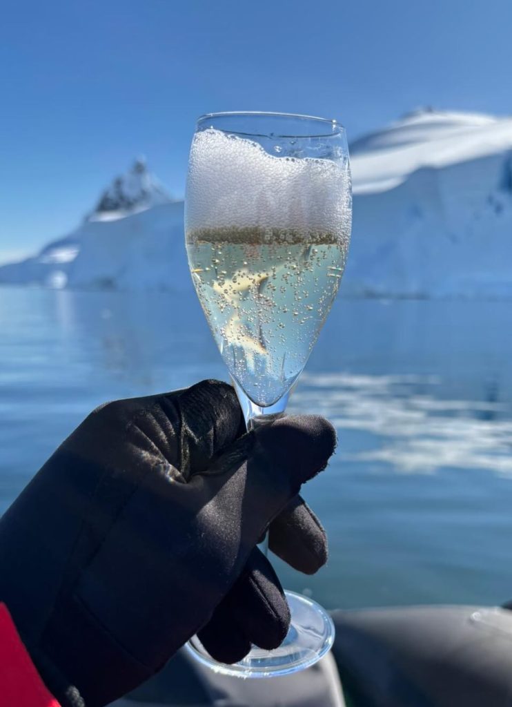
Life is never as simple as just cruising around in a zodiac. Firstly, we were treated to a glass of Champagne, with a touch of the exotic. It was chilled with some ice taken from the bay. Imagine, ice that could been hundreds or even thousands of years old, and had never been touched or even seen by Man.
As we cruised around, two or three whales were spotted. We never managed to get a really closeup view, but someone captured the below video. And for those of us who were privileged to make this trip, we all know who was commenting! She truly added to the excitement of the moment.
Excursion - Danco Island
The afternoon excursion was to Danco Island, a small, ice-covered island situated within the Errera Channel, a narrow body of water separating Danco Island from Rongé Island and the Arctowski Peninsula. The Errera Channel, known for its calm waters and abundant icebergs, makes Danco Island a well-sheltered and accessible location for both scientific study and tourism.
Danco Island is relatively small, measuring around 2 km in length, and features steep, snow-covered slopes leading up to a rounded summit (Danco Hill) at an elevation of approximately 180 meters above sea level (other report a hight of 131 meters). It’s primarily known for its glacially sculpted terrain, biological significance, and historical research presence. The island is mostly covered in ice and snow, but it has a few ice-free rocky areas that provide breeding sites for penguins and seabirds.
One of the most prominent attractions of Danco Island is its large colony of Gentoo penguins, which nest in the rocky areas where snow melts seasonally. The island’s peak also offers spectacular 360-degree views of the surrounding icebergs, glaciers, and towering peaks of the Antarctic Peninsula. During the 1950s, Danco Island hosted a British Antarctic Survey (BAS) station, Station “O”, which operated from 1956 to 1959. It would appear that historically the BAS used a sequential alphabetical naming system, however now they name stations based on geographical locations or historical figures relevant to the UK’s Antarctic exploration.
Danco Island is a common stop for Antarctic cruises, as it provides a relatively easy landing site with gentle slopes, allowing visitors to hike up for views of the surrounding ice fields and peaks.
Danco Island was first charted by the Belgian Antarctic Expedition (1897–1899), led by Adrien de Gerlache de Gomery aboard the RV Belgica. This was one of the earliest scientific expeditions to explore the Antarctic Peninsula.
The island was named in honour of Émile Danco, a Belgian geophysicist and geodesist who was a member of the Belgica expedition. Danco was responsible for gravity and magnetic observations but tragically died from heart problems and exhaustion during the expedition on June 5, 1898, while the ship was trapped in Antarctic ice. His contributions to Antarctic research were recognised by naming this island after him.
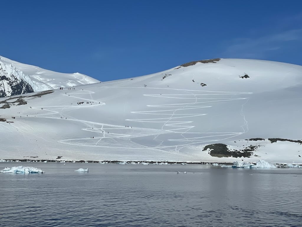
I decided to stay onboard, but I lovingly watched my fellow travellers march up to the top of the hill, and then march down again. They were not “ten thousand men” and I am not the “Old Duke of York”.
But seeing other people doing foolish things, has its moments. After all that effort, that evening I enjoyed a nicely prepared hamburger, as I listened to my fellow travellers telling me about their exploits.
At 19:00 there was a daily recap & briefing, about what had happened during the day, and what was planned for the next day.
9 December 2024 - Portal Point and Eastern Wilhelmina Bay (Day 14)
Calm night, woke around 05:00 local time.
Temperature 0-1°C and a 5-8km/h wind during the day.
Sunrise was at 02:34 and sunset at 23:26.
The day started with breakfast at 07:00, and I avoided the morning beginners lesson in porro dancing.
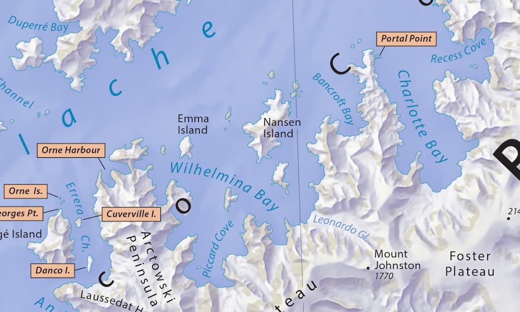
Excursion - Portal Point
Portal Point is a prominent headland located on the Reclus Peninsula, on the western coast of the Antarctic Peninsula in Graham Land. It overlooks Charlotte Bay, which opens into the Gerlačhe Strait.
This region is characterised by steep, ice-covered mountains, deep fjords, and a dynamic marine environment, making it an essential area for both scientific research and tourism. Portal Point is particularly significant as it provides one of the few relatively accessible ice-free landings on the Antarctic Peninsula’s mainland, unlike most sites that are on offshore islands.
Portal Point is a rocky outcrop and former research site, primarily composed of glacially eroded bedrock surrounded by thick ice sheets. It served as an important logistical location for early Antarctic exploration and scientific missions. The area is bordered by glaciers that regularly calve into Charlotte Bay.
Portal Point was selected as a site for a British Antarctic Survey (BAS) hut in 1956, known as “Station P”. The station was used primarily for surveying and geological research.
There is some confusion about “Station P”, since it looks like the name was used for two different locations. There was a “Station P” established in 1956 by the British Antarctic Survey (BAS), at Portal Point on the Antarctic Peninsula. It was abandoned in 1958, leaving only remnants. Another “Station P” was a British field camp (not a full station), established at Hannah Point, Livingston Island, in the South Shetland Islands. It was also active in the period from December 1957 to March 1958. The planned hut was never built due to logistical issues, so it functioned as a temporary camp.
And just to add to the confusion the same British Portal Point hut (once known as “Station P”) was also designated as “CR” (Cape Reclus). This name came from the fact that in 1956 it was established on the Reclus Peninsula. Initially the northern extremity was named “Cap Reclus” after the French geographer and author Élisée Reclus (1830–1905). The UK Antarctic Place-Names Committee (UK-APC) extended the name Reclus to the entire peninsula in 1960. So the hut was occupied until 1958, then dismantled in 1996 and moved to the Falkland Islands Museum in Stanley, where it is now displayed. Today only the concrete foundation blocks remain at Portal Point.
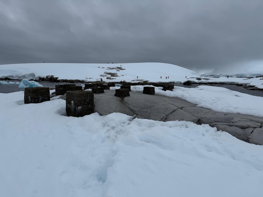
Portal Point was surveyed and named by the Falkland Islands Dependencies Survey (FIDS), a British expedition responsible for early mapping and research in the region. It was used as a primary landing site for British Antarctic Survey (BAS) teams in the 1950s.
The name “Portal” was chosen because the site served as a gateway (“portal”) to the interior of Graham Land, providing one of the few accessible overland routes for inland scientific expeditions.
Excursion - Plata Passage, Eastern Wilhelmina Bay
Our last excursion was called “Zodiac Cruise in the Plata Passage, Eastern Wilhelmina Bay”. We will see that this last trip out was particularly interesting because we visited “close up” a famous shipwreck.
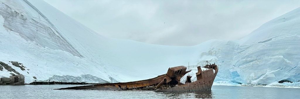
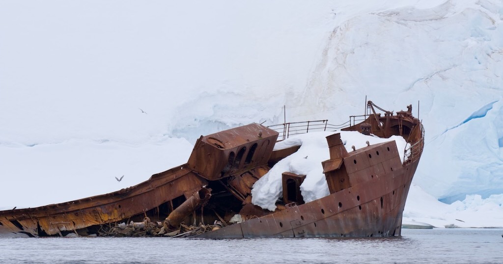
The wreck was the SS Guvernøren, and not the SS Guvernøren (ex-IMO).
“Our” SS Guvernøren (seen above) is tagged as a 5459 gross-ton, 132 metre long, Norwegian whale factory built in 1891, that was destroyed by fire on 27 January 1915.
The “other” SS Guvernøren (ex-IMO) was a 5043 gross-ton, 131 metre long, Norwegian whale factory built in 1899, that ran on to rocks off Cape Carysfort in the Falklands on 30 November 1921. There was one reference to the fact that (unconfirmed) this Guvernøren belonged to the same owner as the earlier Guvernøren. Occasionally “our” ship is referred to Guvernøren I.
“Our” SS Guvernøren was originally a cargo ship built by Palmer’s Shipbuilding & Iron Co. Ltd., Newcastle-Upon-Tyne, and operated between 1891~1907 as the SS Europe by the National Line, Liverpool. One source mentions the SS Guvernøren as a cattle carrier before becoming one of the largest whaling factory ships of her time.
Then between 1907~1911 it was operated by the Atlantic Transport Line. This was a US company that operated ships out of the UK, that were built, registered, flagged and manned from the UK. There is one reference indicating that the ship changed name to SS Mobile.
One report suggests that in 1911 the ship was sold to A/S Hvalfangerselskabet Quilimane. Sometime during the period 1911~1913 the ship, now named FLK Thøger, appears to have been operated by a certain Andersen Thøger, from Larvik in Norway. In 1912 it was refitted as a whale factory by Framnæs Mekaniske Versksted, Sandefjord (Norway). One report mentioned that it was the most extensive conversion carried out at the shipyard to that time, and the “cooking equipment” was the most modern on the market. Another report mentioned that after a weak fishing season off the coast of Africa, “Thøger” was purchased in 1913 by Haldor Virik in Sandefjord and renamed FLK “Guvernøren”. Through the “Odd” Whaling Company, Virik had a license to hunt in the Antarctic.
A summary report simply stated that on January 27th, 1915, the Guvernøren caught fire and was lost at Oddharbour, South Shetlands. The crew was saved, but the ship with 16,614 barrels of whale oil was lost. Another report indicated that the ship was scuttled by whaling harpoons.
The “Odd” and “Normanna” companies were mentioned as being owned by the same people, and after the fire they continued with the Normanna floating factory and Norman 1, Norman 2, and Odd 2, as catchers.
It was Captain Leif Bryde, Manager of the “Odd” Whaling Company, who “lost” the ship. There is correspondence that shows that the ship was insured for Kr. 600,000, and the cargo of oil was insured at the rate of Kr.70, per barrel. The English language used in the correspondence is a perfect example of the politeness of the times.
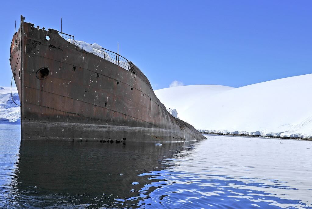
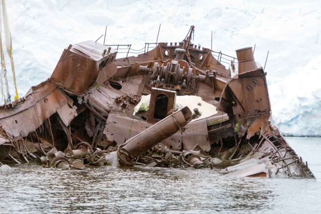
So what happened? On January 27, 1915, the Guvernøren was at sea, performing her duties as a floating factory.
At the time, building whaling facilities on land in Antarctica wasn’t always feasible. Decent sized ships like Guvernøren became ideal carriers of everything needed for hunting and harpooning whales. The crew was capable of rendering entire whales into oil and other valuable commodities. These factory ships also carried large boilers with enormous tanks for holding and storing the finished whale oil until the vessel reached its final destination.
In terms of capacity, the Guvernøren was known for once producing more than 22,000 gallons of oil. The Norwegians considered the ship a leader among factory ships and one of the most technically sophisticated.
Guvernøren’s last mission
As this particular 1915 whaling mission wrapped up, the crew threw a party (as was standard practice aboard floating factories) to celebrate the success of a long and laborious mission hunting and processing whales, and the anticipated journey home. Because Guvernøren’s working decks were designed for flensing, and not for dancing and partying, the celebration was held below decks.
Someone, perhaps while dancing too boisterously, knocked a lamp off a table and the ship caught fire. The Guvernøren had thousands of gallons of whale oil on board, ready and waiting to be hauled back to Norway. This oil fueled the fire, causing it to quickly grow out of control.
Although resulting in the terrible loss of whale oil and of a historic ship, the captain grounded Guvernøren at Foyn Harbour (named after another floating whaling factory, Svend Foyn) and the entire crew of 85 were able to escape, only to watch the blazing ship burn to ruin.
None of the crew members were injured by the fire, and all were rescued by another whaling vessel.
The story also mentions that the captain ordered one of the whalers to shoot a harpoon into the Guvernøren to deliberately sink it in an attempt to save the oil. The crew of 85 got into their work boats and were later saved.
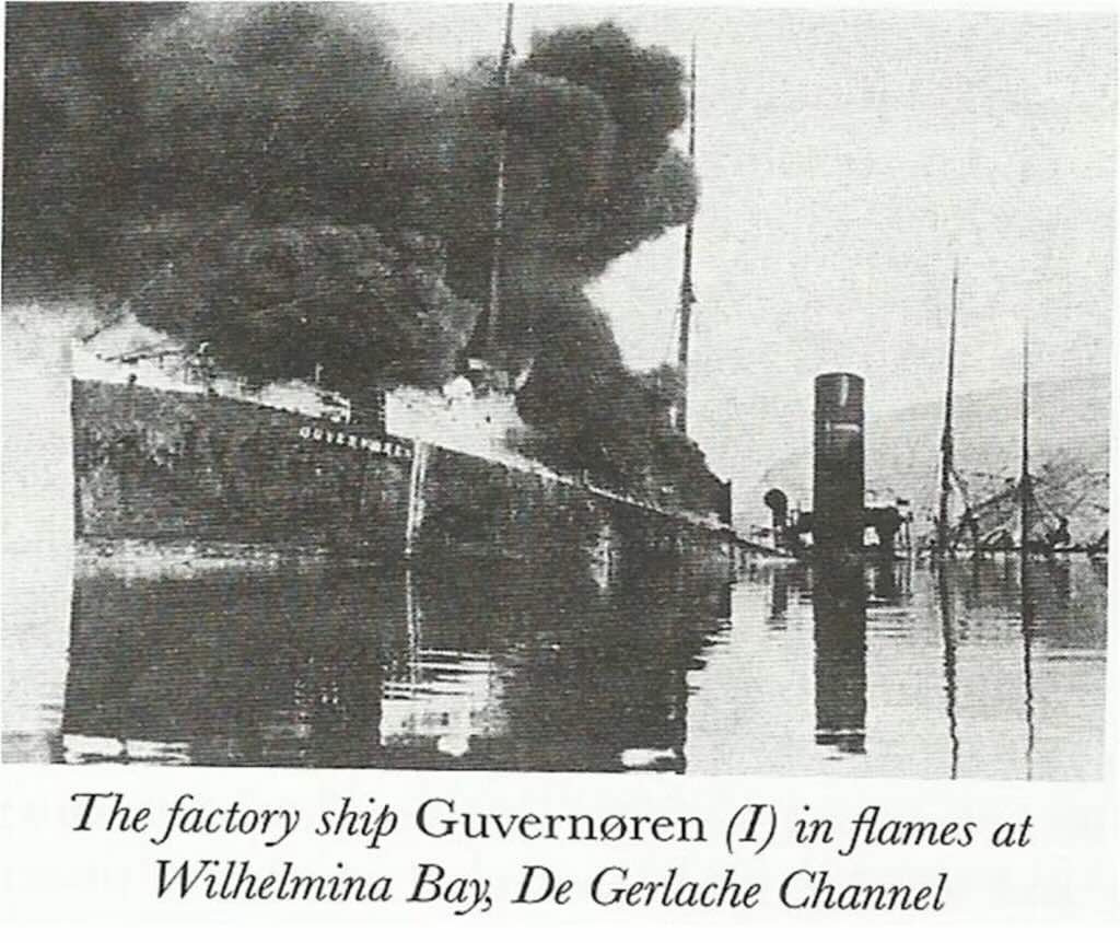
Now we get to the tricky bit, or interesting bit, if you prefer. Where exactly is this wreck? We can see it in the photos, it exists.
Our visit was titled “Zodiac Cruise in the Plata Passage, Eastern Wilhelmina Bay”. The reality is that, as pointed out in the Wikipedia entry, Plata Passage is just a wide passage area between one of islands in Wilhelmina Bay, and west coast of Graham Land on the Antarctic Peninsula. Above we have the press announcement at the time, that just places it is the biggest local area of water, namely the De Gerlache Channel.
We get nearer to the exact location of Guvernøren, when we note that our cameras geo-tag the photos as being taken in “Enterprise Island“. We learn that this is a small island lying at the northeast end of Nansen Island in Wilhelmina Bay.
But clearly the wreck is in some kind of bay.
Many of the background descriptions the Guvernøren wreck, including by people who actually have dived to see the wreak partially submerged, stated that it is found in “Foyn Harbour“.
Wikipedia includes next to Foyn Harbour, a photo of the wreck, with the caption “The wreck of the whaling factory ship Guvernøren in Foyn Harbor”.
But on the very same page Wikipedia also states “Gouvernøren Harbor. A small harbor indenting the east side of Enterprise Island just west of Pythia Island in Wilhelmina Bay. The name was applied by whalers using the harbor because the whaling vessel Gouvernøren I was wrecked there in 1916”.
So on the same page Wikipedia places the Gouvernøren wreck in both Foyn Harbour and Gouvernøren Harbour.
I tried for several weeks to solve this geo-tag mystery. I contacted different mapping and Antarctic cruise companies, to find an answer… Most did not reply, and those that did said that they didn’t know.
So my best bet is that the Gouvernøren wreck is in Gouvernøren Harbour (see map below).
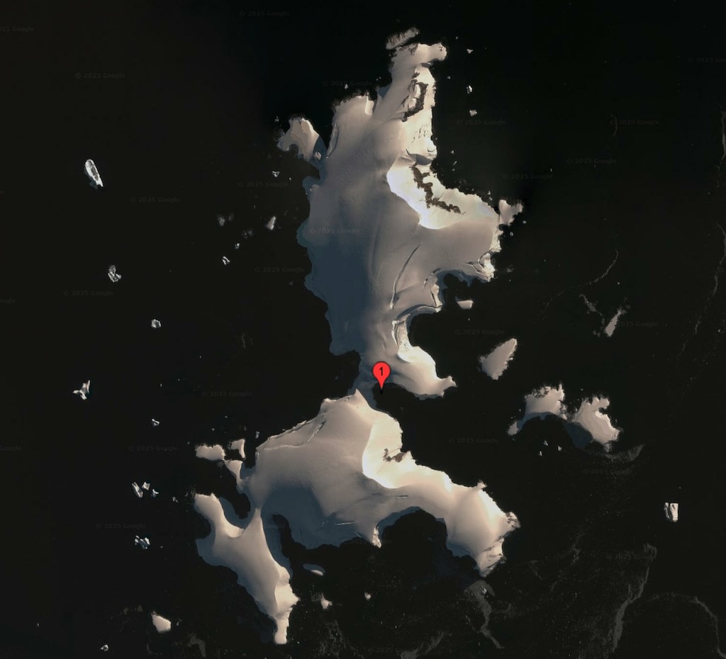
At 17:30 there was a daily recap & briefing, about what had happened during the day, and what was planned for the next day.
10 December 2024 - return to Ushuaia (Day 15)
Calm night, woke around 04:30 local time.
Temperature 2°C and a 16km/h wind during the day.
Sunrise was at 02:49 and sunset at 22:50.
The day started with breakfast at 07:00, and I did not attend the 09:15 nautical knots workshop.
At 10:15 there was a presentation “Heroic Age of Exploration of Antarctica“.
At 16:30 there was a presentation “By the way, who does Antarctica belong to?“
At 18:30 there was a “Farewell Cocktail” hosted by the ships Captain, followed by another Gala Dinner. I avoided the “Rock ‘n’ Roll Hour” at 21.30, and simply waltzed down to my cabin.
Possibly the most important event of the day was the “Last call for the laundry” at 12:00, although both presentations were interesting.
11 December 2024 - return to Ushuaia (Day 16)
Calm night, woke around 04:30 local time.
Temperature 5°C and a 18-21km/h wind during the day.
Sunrise was at 03:14 and sunset at 21:09.
The day started with breakfast at 07:00, and I might add that I continued to avoid visiting the ships Boutique, so I did not “discover the new collection” nor “treat myself to the finest souvenirs of my cruise”.
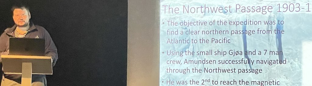
At 09:30 there was a presentation “Amundsen and Scott: The Race to the South Pole“.
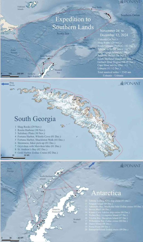
At 14:00 there was the final recap & briefing, about what had happened during the day. This session was divided into a review of the excursions presented by the Expedition leader, John Frick. But it was then followed up by what can only be called comic sketches presented by a number of the expedition team. They were all funny, but some were very professional as well.
I must admit I can’t remember all the names, but I do remember (vaguely):-
John Frick (far right in the photo) who was the expedition leader. An interesting personality, American, but he had lived in Alaska and Nepal, and was an experienced team leader for various expedition and educational cruise companies.
Alexandra Morozova (I think third from right) was a guide focussed on marine life and polar exploration history. She was born in Russia, but also lived for a while in Svalbard. A very nice and friendly woman.
Paton Small (fourth from the left) was an American and always enthusiastic about everything. He had worked on a number of scientific research projects, but was clearly deeply passionate about archaeology, geology and rocks (and more rocks).
Lorena Alvarez (small woman in the middle, or maybe the second from the right) was from Chile Patagonia. Another person alway easy going and enthusiastic about Chile, exploration history, and life in general.
Lars (the big guy in the middle) was from Norway (if I remember rightly). In many ways the most complex and interesting person, with a deep knowledge of marine life and the history of exploration.
At 17:30 there was a Disembarkation Talk, outlining the different steps that would bring all passengers safe and sound to the airport the next day.
We docked in Ushuaia early evening, and spent the night onboard.
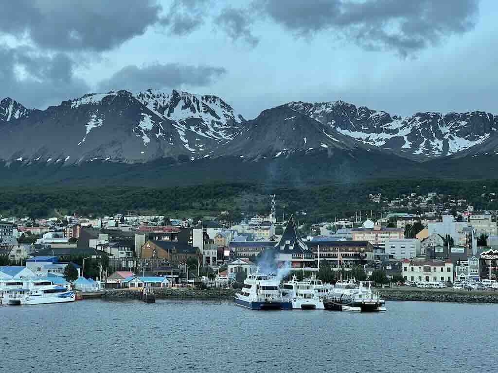
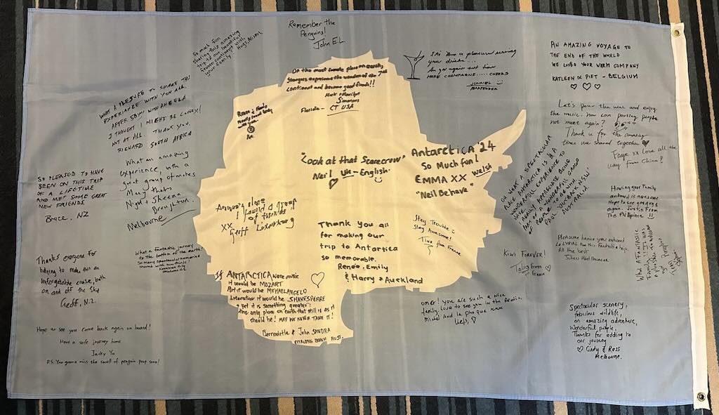
One of the most important things about the cruise, at least from my viewpoint, was the people I met.
I was very lucky to be welcomed into a group of fellow travellers. And I will always be eternally grateful for those moments of friendship.
Above is a flag that everyone signed, and below a group photo.
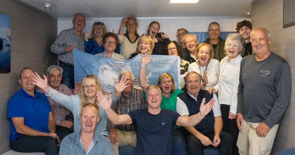
12 December 2024 - Ushuaia to Buenos Aires (Day 17)
Calm night, woke around 03:30 local time.
The day started with a luggage pickup at 06:00. Luggage had to be left in front of the cabin door before 06:00. Later afternoon-evening of the 11th the last Daily Program was distributed along with an invoice for extras, a “bye-bye” letter with the general program for the day, and luggage labels. Each passenger-cabin was allocated a colour luggage label which corresponded to a group and one of six coaches, e.g. Green label was Group 4, with a departure time of 08:30.
Breakfast was from at 06:00 to 09:00, but the cabins had to be vacated before 08:00 at the latest.
Passports had to picked up from 06:30.
The cabin electronic key card, which severed as an ID for leaving and entering the ship, had to be scanned when finally leaving the ship. The card could be kept as a souvenir.
Everyone had left the ship by 09:00. The reason was simple, Le Lyrial was chartered, and new passengers were expected at around 16:00. It was interesting to see in the airport parking some of the guides who had accompanied us on the coaches changing their Ponant jackets for Abercrombie and Kent jackets.
An additional breakfast had been organised at Club 1210 in the city, and we had ample time to visit the city centre. Also the coach trip included a tourist visit to see the residential areas of the city, before going to the airport.
I had a simple objective. I had broken a shoe lace, and needed to buy a new set for my walking boots. This was an intriguing test. Firstly, the advice was to go to one of the small stores that sell everything,… except shoe laces! Secondly, there were a surprising number of shoe shops, most still closed at 10:00, and some still closed at 11:00. They sold shoes and boots,… but not laces! Finally, I found one shop who had a collection of different boot laces. Cost for two pairs, €3, time spent 1½ hours.
Someone might view the city of Ushuaia through their rose-coloured glasses and conclude that its architecture reflects a mix of European influences, Patagonian resilience, and maritime aesthetics. Traditional wooden buildings, many brightly painted, were originally constructed by early settlers, including missionaries and prisoners from the penal colony established in the early 20th century. Frankly, in my opinion, in some cases the buildings were still standing thanks only to the good will of the paint.
No doubt a well meaning academic might think that Ushuaia’s wooden architecture provides a glimpse into its history as a remote outpost shaped by seafarers, prisoners, and immigrants. The city appeared to be trying to save a patrimony that might not want to be saves, and/or replacing it with some utilitarian cement that didn’t want to be there, and appeared not to support well the extreme climate. And I won’t mention the overhead power cables and the drains that weren’t,… draining that is.
The natural scenery is exceptional, and you can fully understand some people wanting to spend three days drive south through Patagonia to discover the “End of the World”. However, at times the city’s architecture and buildings smacked more of “end of civilisation”.
It is true that Ushuaia has a certain quaint charm, but it soon wears off.