This is part-2 of a 2-part report on my trip (July 2025) to Svalbard in the Arctic on the Quark Ocean Explorer. Here is the full list of my posts:-
- Travel – Planning a cruise to the Arctic
- Hotel – Hilton Airport, Helsinki
- Places – Arctic I
- Places – Arctic II
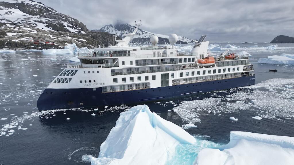
- Travel – Quark Ocean Explorer
Before my Arctic trip I also decided to visit Helsinki, and I stayed in Solo Sokos Hotel Torni. After my trip I returned to Helsinki and stayed in the Hotel Kamp.
Three weeks after arriving back home we all received access to a >20GB dropbox archive, including a 16 minute video. My Arctic trip report includes a few of my photos, and some excellent wildlife photos taken by the explorer team.
Also throughout this trip report, I will occasionally reference the trip I made to the Antarctic (late Nov. to early Dec. 2024). The best entry point for my trip report is “Travel – Antarctic on Le Lyrial (Days 1-7)“.
The Ocean Explorer itinerary
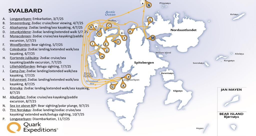
What you book for is a provisional, or ideal, itinerary. but changes can be made due to weather, wildlife spotting, etc.
Above we have the actual itinerary of our cruise, including the different kinds of excursions, and any important wildlife spotting’s.
8 July 2025 (Day 6)
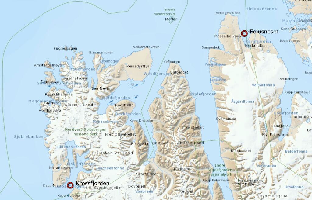
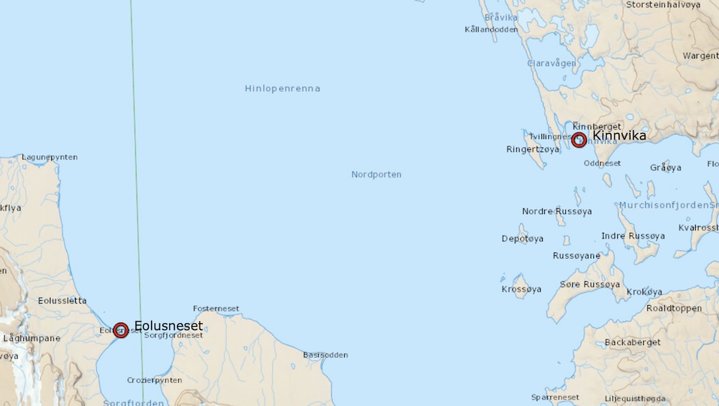
We made the trip from Krossfjoren to Eolusneset (Sorgfjorden) overnight. The cruise distance between the two was ~150–165 nautical miles, and leaving at approximately 18:00 and arriving around 06:00 the next day, the cruise speed would have been ~12.5–13 knots (so slightly above the ships eco-cruise speed of ~10–11 knots).
09:15 Eolusneset (zodiac landing/walk)
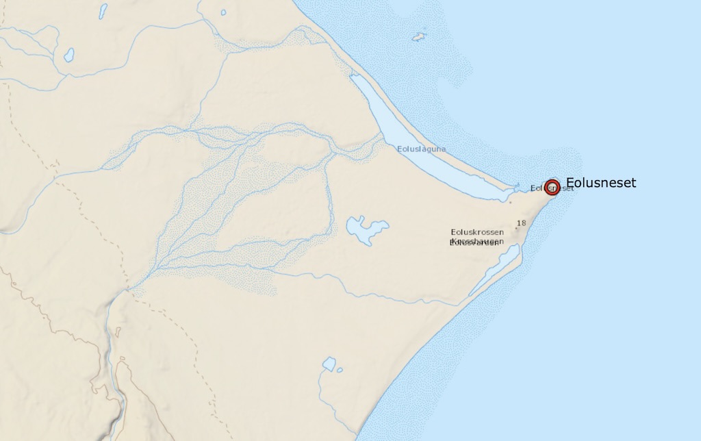
We came ashore along the spit shown below the location pointer on the above map.
Eolusneset is a rocky headland on the western shore of Sorgfjorden, and is named after the Norwegian sealing schooner Æolus.
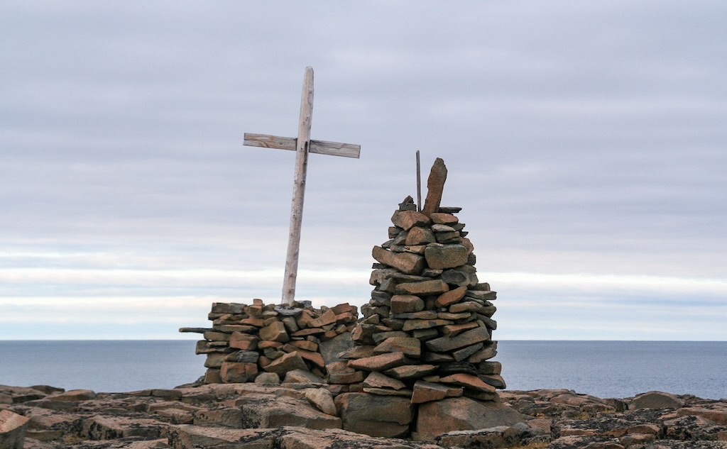
In the distance there is the “Æolus Cross” atop a small hill. It was erected in 1855 by the captain of Æolus to honour fallen sailors from a 1693 naval clash in Sorgfjorden.
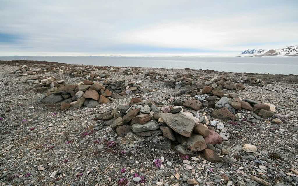
Nearby there is a historic burial ground with around 30 graves from 17th–18th‑century whalers, each marked by a cairn.
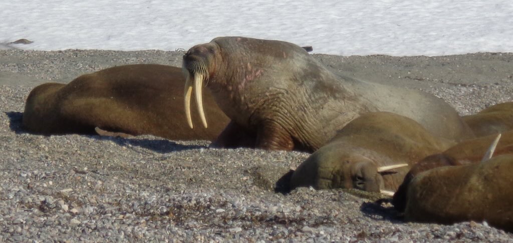
The main objective of our visit to this sites was to see some walruses.
What we saw was a group of male walruses (often called bulls) rests on the gravel beach of Eolusneset, displaying typical haul-out behaviour. The animals lay closely packed, their massive bodies heaped together, occasionally shifting or vocalising. With minimal movement, they conserve energy, relying on blubber insulation and social proximity. This classical onshore comportment is characteristic of bachelor groups during non-breeding periods in Arctic summer.
The walrus (Odobenus rosmarus) is a large, gregarious marine mammal found in Arctic and sub-Arctic regions. Adult males can reach 3.5 meters in length and weigh up to 1,500 kilograms (females are slightly smaller, and are often called cows). Both sexes have long, curved tusks, elongated upper canines, that can grow over 1 meter and are used for dominance, defence, and hauling out. Walruses can live over 40 years. They are distinguished by their very thick, wrinkled skin, prominent vibrissae (whiskers), and a thick layer of blubber for insulation.
Walruses can show notable variation in skin colour, primarily due to physiological and environmental factors rather than genetic pigmentation. When cold, a walrus appears pale grey to light brown. Blood vessels in the skin constrict (vasoconstriction) to conserve heat, reducing blood flow near the surface. When warm, especially after physical exertion or in the sun, a walrus may turn pink to reddish. Blood vessels dilate (vasodilation) to release excess heat through the skin. This is particularly noticeable in hauled-out animals in sunlight or in warm weather.
And age and molt cycle can also be responsible for colour variations. Calves are born with fine, dark brown hair and often appear darker than adults. As they age, hair becomes sparse, and older walruses tend to appear paler. Walruses undergo annual molting, shedding old skin. During this time, skin may appear rough, patchy, or discoloured (reddish-brown to yellowish), especially on land.
Finally, walruses that rest or forage in iron-rich sediments may show orange, yellow, or rusty staining, especially around the tusks and face.
Their whiskers, or vibrissae, are highly sensitive, thick, and bristle-like, and can numbering up to 700 on the snout in symmetrical rows. Each vibrissa is embedded in a blood-rich pad and connected to muscles and nerves, allowing precise tactile sensing. Walruses use them to detect and identify prey on the seafloor, particularly bivalve mollusks, in near-total darkness or murky water. The vibrissae are crucial for foraging, far more important than eyesight, and are constantly swept along the bottom as the walrus roots through sediment.
A walrus tusk is an elongated upper canine tooth found in both male and female walruses. The tusks are made of ivory (dentine covered in enamel early in life, which wears off). They continuously growing throughout the walrus’s life. Tusks are typically longer and thicker in males, reaching up to 1 meter and can weigh over 5 kg each.
In males, tusks are used to establish hierarchy and display strength during mating season. However, direct combat is rare, and display postures and tusk size often suffice. Walruses also use their tusks like ice picks, anchoring them into ice to pull their massive bodies out of the water, hence the nickname “tooth-walkers”. While not primary tools for digging, they may help disturb sediment or break through ice. Finally tusks can be used to fend off predators like polar bears or orcas.
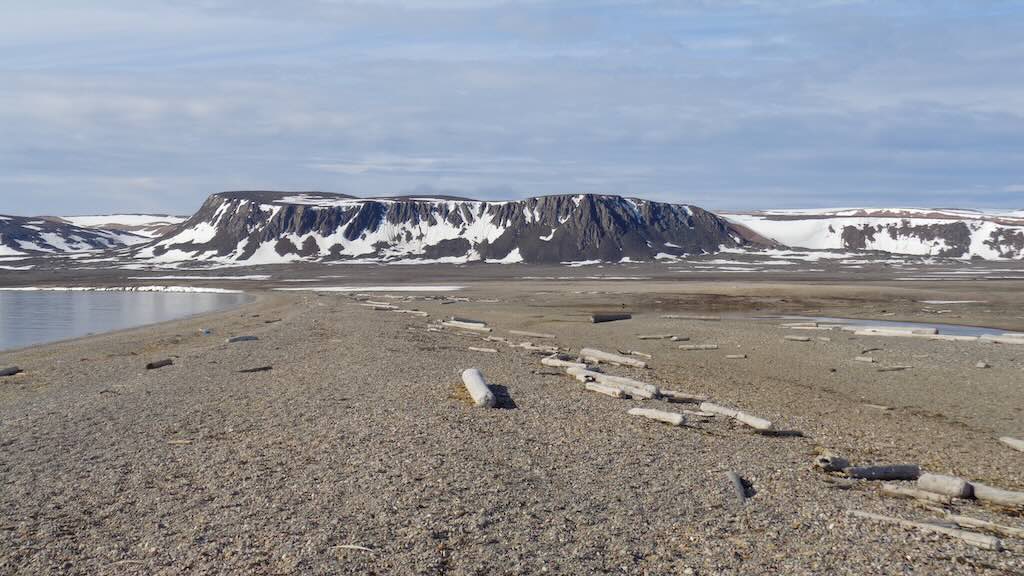
The flat-topped mountains of Eolusneset are remnants of an ancient peneplain, an erosion surface formed millions of years ago when the region was near sea level. Later tectonic uplift raised the land, preserving the flat summits as high plateaus. During the Quaternary ice ages (that began 2.58 Ma and is still ongoing), extensive glaciation carved and deepened surrounding valleys but left the resistant plateau tops relatively intact. The result is a landscape of broad, flat mountain tops and steep-sided troughs typical of glacially sculpted terrains in high Arctic regions.
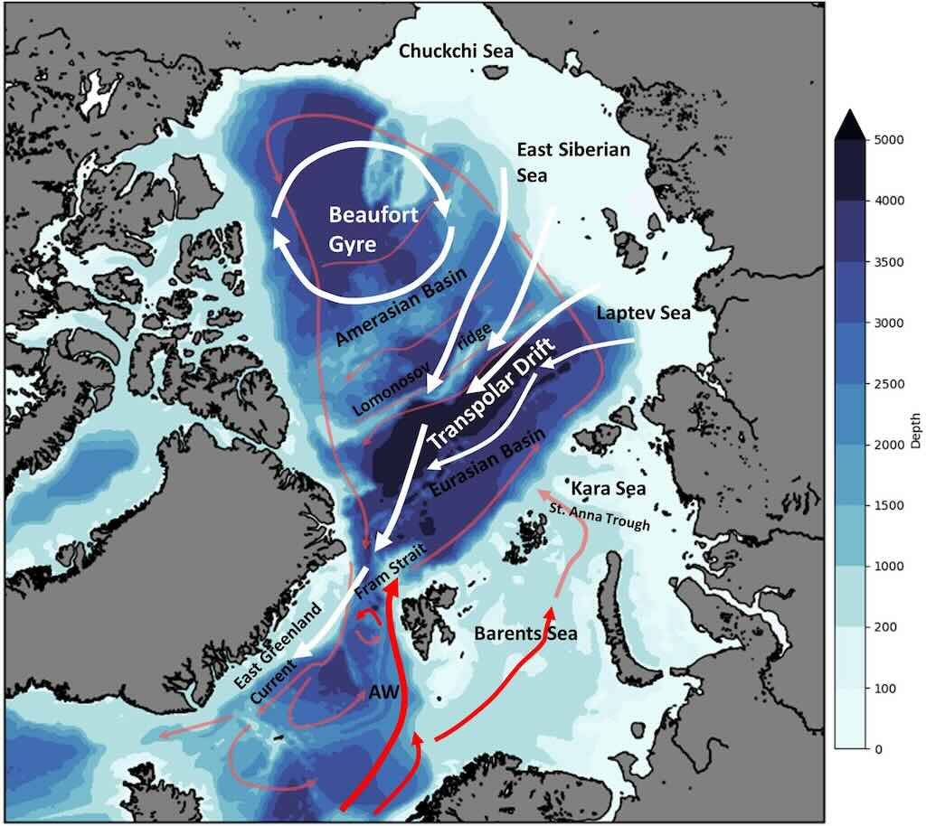
Above we have a schematic of major current features in the Arctic Ocean and North Atlantic. The coloured contours indicate the bathymetry (water depth in metres). Atlantic water (AW, red lines) enters the Arctic Ocean through the Fram Strait (the passage between Greenland and Svalbard) and via a separate branch through the Barents/Kara Seas, then circulates the Arctic Basin as a subsurface current (light red). The Beaufort Gyre and the Transpolar Drift are surface features (indicated by white arrows) that influence sea ice drift patterns.
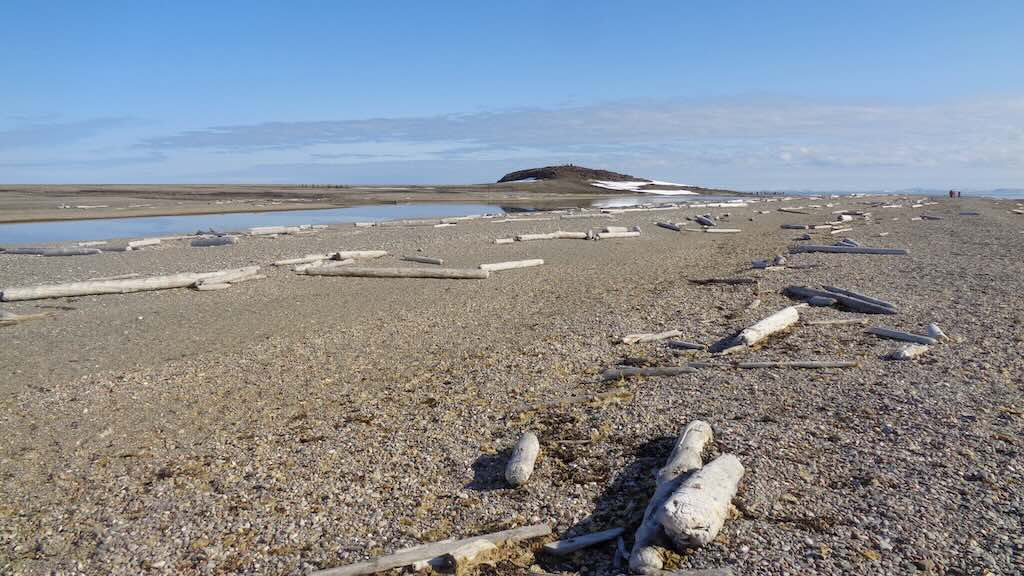
We have seen in various places driftwood scattered along the shores (sometimes quite abundant as seen in the above photos). This wood originates primarily from boreal forests in Siberia. Logs, mostly spruce (Picea) and larch (Larix), are carried by major Siberian rivers such as the Lena, Ob, and Yenisei into the Arctic Ocean. Trapped in sea ice or transported by ocean currents, particularly the Transpolar Drift, the wood can travel thousands of kilometres before washing ashore in places like Svalbard. Despite prolonged exposure to salt water and ice, the wood is often remarkably well-preserved. Historically, this driftwood was a vital resource for Arctic peoples and early explorers, who used the wood for fuel, tools, and shelter in treeless polar environments. However, Arctic explorers and whalers often brought their own sawn wood for building huts, coffins, and repair work. Imported timber was more reliable for construction (straighter, pre-cut, and seasoned), whereas driftwood, despite being abundant, was of uncertain size, moisture, and structural integrity. Both types of wood were essential when survival depended on adaptation, improvisation, and preparedness in the inhospitable high Arctic.
14:15 Kinnvika, Murchisonfjord (zodiac landing/walk)
Once back onboard we left immediately for Kinnvika, Murchisonfjorden. The distance looks bigger but it was only ≈17 nautical miles, and took around 90 minutes.
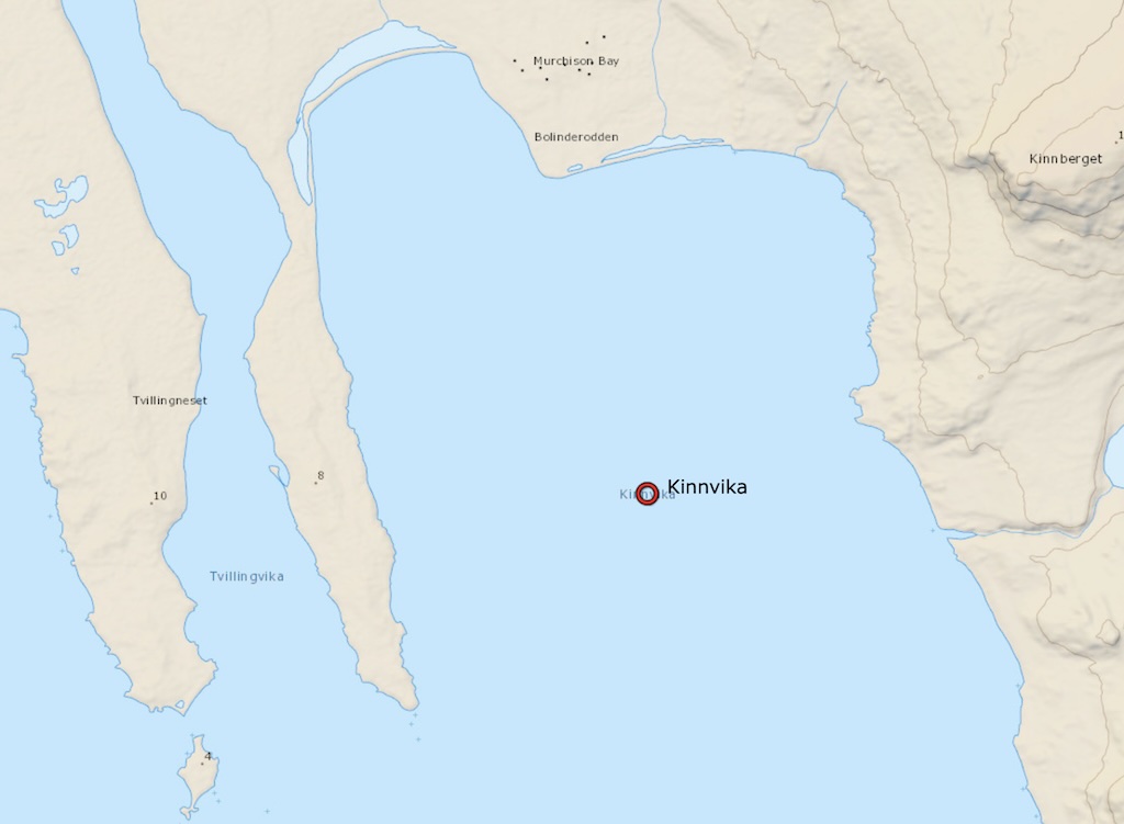
Kinnvika is a remote scientific research station on Nordaustlandet, the second-largest island in the Svalbard archipelago.
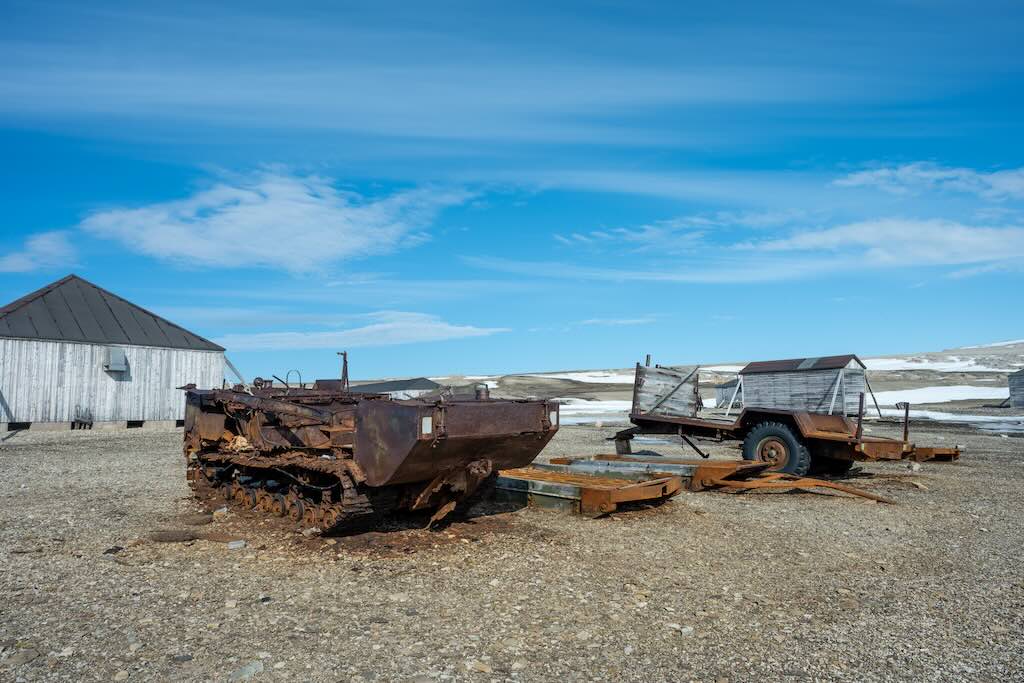
Kinnvika was built as a central base for a Swedish–Finnish–Swiss Arctic expedition during the International Geophysical Year (IGY) of 1957–1958. It was one of the most ambitious polar scientific efforts of the Cold War era. The IGY was a massive international initiative involving over 60 countries, and Kinnvika was a hub for meteorology, glaciology, geophysics, and upper atmosphere research (ionospheric studies).
The main building and outbuildings, constructed during that time, remain preserved in the Arctic landscape, frozen in both time and ice. Today the site is located in a part of the Arctic with growing strategic interest due to the melting ice opening new sea routes (e.g. Northern Sea Route), and the potential for untapped natural resources (oil, gas, rare minerals).
Kinnvika is now considered an important part of Svalbard’s cultural heritage. Its wooden buildings and layout are protected under Norwegian law. It stands as a frozen museum of the IGY, capturing Cold War scientific cooperation. In the 21st century, Kinnvika has been reused in various collaborative projects, including IPY-Kinnvika (2007–2009). which was part of the International Polar Year revival.
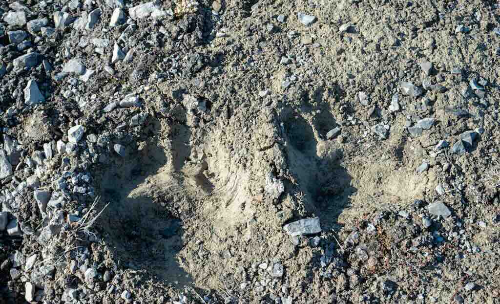
These places can look totally abandoned, except that one of the explorer team spotted some recent polar bear footprints. An adult male polar bear footprint will be about 35 cm long and 30 cm wide, his feet are more like paddles when swimming. Also standing he will likely be between 2½ and 3 metres tall, and weigh anything between 350–700 kg. And if you are near enough to see him 100 metres away, remember he can run at up to 40 km/h. So he can cover that 100 metres in about 9 seconds. Usain Bolt managed to cover the same distance in 9.58 seconds.
What does "untapped natural resources" actually mean?
This kind of comment is increasingly thrown on to any specific location, almost anywhere in the “High Arctic”.
The article “The View from the Top – Searching for responses to a rapidly changing Arctic” quite rightly says…
“Land ice is also retreating, while snow is disappearing and permafrost is thawing. Rapid environmental change in the Arctic, as a result of climate change, is providing new development opportunities including easier access to oil and gas, minerals and fisheries”.
It goes on to say that it’s true that the Arctic has been warming at least twice as fast as the global average. One reason is that more heat is being brought into the Arctic through the atmosphere and with ocean currents. The greatest local amplification is due to the melting itself, which reduces the reflection of incoming sunlight. White ice and snow act as a mirror, reflecting about 85% of solar radiation back to the sky. Dark ice-free areas of the ocean reflect only about 10% and absorb the rest, while bare tundra reflects about 20%.
But the article also points out that resource exploitation is not new in the Arctic. Major longstanding developments include oil drilling on the North Slope of Alaska, natural gas or methane extraction on Russia’s Yamal peninsula, and mining of metals around Norilsk, Russia, the world’s largest source of nickel and palladium. But its recognised that as ice and snow recede, making access and transport easier, the Arctic is expected to play a greatly expanded role in world energy and minerals supplies.
The article is well worth reading because it provides a very effective overview of the impact of global warming on the Arctic.
Let’s look at what that means to a precise area in the Arctic, namely the region around Kinnvika. So firstly, Kinnvika is indeed geographically located within the High Arctic, a zone that is strategically interesting due to melting sea ice, which can certainly affect shipping lanes and naval interests. And it’s also true that there is an increased focus on the potential of untapped resource, particularly in adjacent Arctic continental shelf areas (e.g. Barents Sea, Kara Sea, Greenland shelf, Canadian Arctic Archipelago).
But there is no confirmed resource base (oil, gas, or critical minerals) in the immediate area of Kinnvika, and the geology would suggest low prospectivity.
Kinnvika lies outside any known hydrocarbon rich zones, and the (limited) available data suggest a low likelihood of nearby hydrocarbon systems. There are no known Rare Earth Elements (REE)-bearing pegmatites, carbonatites, or mineralised mafic bodies have been identified in the immediate Kinnvika region.
And finally Kinnvika lies within the Nordaust-Svalbard Nature Reserve, and all resource exploration and exploitation are prohibited.
But what about these "new sea routes"?
What has been observed is that Arctic surface air temperatures have increased at more than three times the global average rate (Arctic amplification). The extent and thickness of sea ice have declined significantly since satellite observations began in 1979. Summer minimum sea ice extent has decreased by approximately 13% per decade. And multi-year ice has been increasingly replaced by thinner first-year ice.
Most climate models project nearly ice-free Arctic summers by the 2050s, and seasonal navigability of Arctic sea routes is expected to increase.
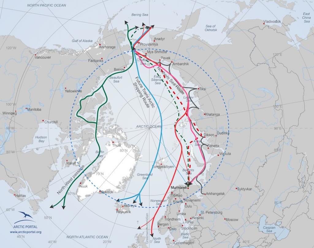
The Northern Sea Route (NSR) is Russian controlled but is already seasonally navigable (July–October) with icebreaker escort, however the Northwest Passage (NWP) is still limited by narrow straits, multi-year ice, and shallow depths.
The main idea is for a Transpolar Route (Central Arctic Shipping Route), a direct route across the central Arctic Ocean, passing near the North Pole. Currently its blocked by thick multi-year ice, but by the mid-century, under high-emission scenarios, it could become seasonally navigable (late August–early October).
This option is on everyones “radar screen” because it could be 25–50% shorter than traditional routes. This would reduced transit time (up to ~14 days saved per voyage) and lower fuel use (and thus emissions per unit of cargo).
18:00 BBQ Dinner
A pleasant idea, since the weather allowed us to sit outside (and inside) and have a BBQ on the top panoramic deck.
Great atmosphere, they should have done this much earlier and more often.
Cooking on deck was more frequently used on the Antarctic Ponant cruise.

For some reason, possible linked to our emergency trip back to Longyearbyen, it was decided to add a third visit. This time to Alkefjellet, a bird cliff in Lomfjordhalvøya.
The distance for Kinnvika was ~28 nautical miles, and took a little over two hours.

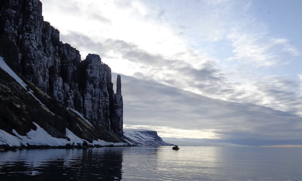
Alkefjellet (Norwegian for “Auk Cliff”) is a prominent bird cliff located on the largest island in the Svalbard archipelago. Specifically, it lies along the Hinlopen Strait, near the mouth of the Lomfjordhalvøya peninsula, and is part of the Nordaust-Svalbard Nature Reserve.
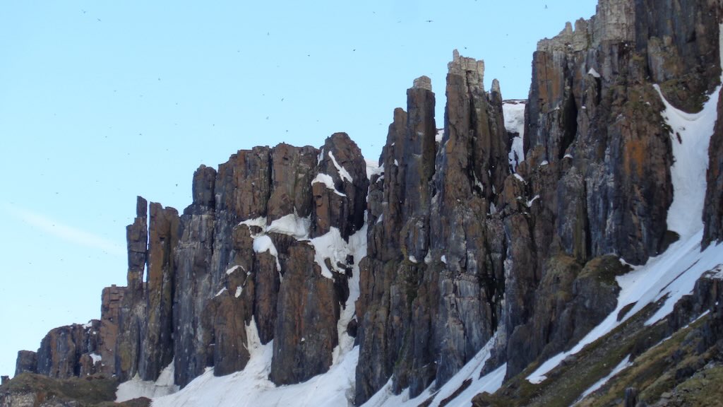
The cliff face rises vertically up to 100 meters above sea level, and is composed primarily of dolerite intrusions and sedimentary rocks (including shales and limestones) from the Jurassic period (160–180 million years ago), which create the steep vertical structure suitable for nesting seabirds. In simple terms it was created by magma intruded into horizontal layers of softer sedimentary rocks. The magma cooled underground, forming thick dolerite sills that later became exposed as the sedimentary rock was eroded away.
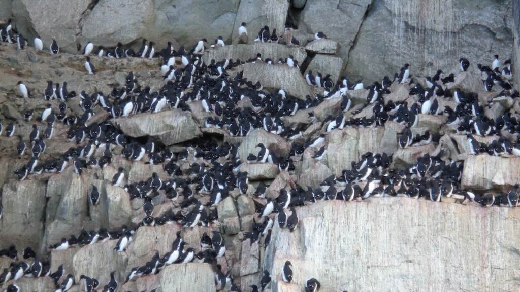
Alkefjellet is one of Svalbard’s most important seabird colonies. It is especially known for its massive breeding population of Brünnich’s guillemots (Uria lomvia), with an estimated 60,000 to 100,000 pairs nesting on its ledges. Other species on the site included the Black-legged kittiwake (Rissa tridactyla) and the Glaucous gull (Larus hyperboreus).
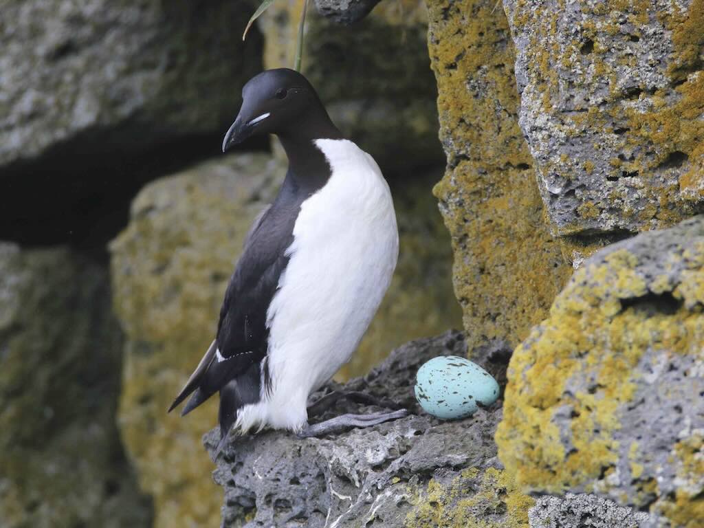
Brünnich’s guillemots, also known as thick-billed murres, are in the auk family that breeds in large colonies across the Arctic. They are black-and-white birds with a thick, short bill and a white line along the bill’s base.
They nest on steep coastal cliffs, shoulder-to-shoulder with virtually no nest structure, relying on strong parental coordination to prevent eggs from falling. They have one egg per pair, laid directly on bare rock.
Their food is primarily fish (like polar cod and capelin), but also crustaceans. They can dive over 150 meters deep, and can stay submerged up to 4 minutes, using their wings to ‘fly’ underwater.
The egg’s colour varies from pale blue to turquoise and may be blotched or streaked. One idea is that the blue pigment, biliverdin, may have antioxidant or antimicrobial properties, helping to protect the egg in unsanitary conditions typical of guillemot colonies. Each egg has a unique pattern, and in dense colonies with thousands of birds, a bright egg with a specific pattern is more easily recognised by the parent, especially when returning from sea. It’s also worth noting that guillemot eggs are unusually pointed at one end. This causes them to roll in tight circles rather than off the cliff, a vital adaptation for exposed nesting ledges.
It’s interesting that other cliff-nesting seabirds like razorbills and some kittiwakes also lay more pointed or pyriform eggs. However, only birds that nest on narrow or exposed ledges without building a nest have evolved this adaptation. It’s logical to assume that egg shape must reflect some kind of trade-off between nesting environment, clutch size, body shape, and flight adaptation. So in this case the most important “constraint” was trying to keep the egg on the ledge.
You may ask, why didn’t guillemots just nest somewhere else, rather than evolve weirdly shaped eggs to cope with dangerous cliffs? The answer is just as simple, because nesting on cliffs gives them massive survival advantages that outweigh the risks. The idea is that they avoid ground predators such as arctic foxes, and they don’t have to compete with other birds for nesting places. In addition they can nest shoulder-to-shoulder, thousands strong, maximising communal protection and space use. And don’t forget sea cliffs usually border productive oceans. This makes feeding chicks much easier. The evolutionary downside to “nesting” on vertical rocks, is that nesting materials are scarce on cliffs, and even, once built, would be vulnerable to wind. The answer was to stay of a sheer rock face, not build a nest, and evolve a shell that didn’t roll off.
One egg means there is still space on the rock to protect it, and both male and female guillemots take turns incubating their precious single egg. In fact the egg is held upright, pointed end down, balanced on the bird’s feet and under its belly feathers. After hatching, one parent usually stays behind to guard the chick from gulls and other threats while the other hunts for food to bring back.
There is also a very specific “cliff jump” culture. Around 20 days old, while still flightless and fluffy, the chick leaps off the cliff to the sea below. This is done at night, often with the father calling from the water below. The male guillemot then guides and feeds the chick at sea for several more weeks, and the female often no long participates in “child care”.
As seen in the photos and video, guillemots exhibit one of the most crowded breeding systems of any bird species on Earth. Each pair claims a tiny spot, often just 10–15 cm wide, sometimes even touching their neighbours. There is no physical boundary or nest, just a strong sense of site fidelity, and each bird returns to the exact same spot each year. Amazingly they recognise their specific nesting spot, mate, and neighbour pairs.
Colonies often exhibit synchronised breeding, incubation, and chick-rearing. This timing reduces predator impact by overwhelming predators with too many targets at once (a strategy called predator swamping).
The above photo was taken at about 21:30, and “captured the moment”, whilst also signalling that there was still a lot to see and discover.
If anything, this extra third trip, was one of the cruise highlights.
9 July 2025 (Day 7)
It was announced that today we would be heading north, towards the “ice edge“.
Generally, the ice edge refers to the boundary between open water and sea ice.
In satellite data analysis, the ice edge is the line where sea ice concentration drops below 15%, i.e. where navigable open water begins.
For sailors, the ice edge is often interpreted as the furthest extent of significant or hazardous sea ice, and it can change daily based on wind, current, and temperature.
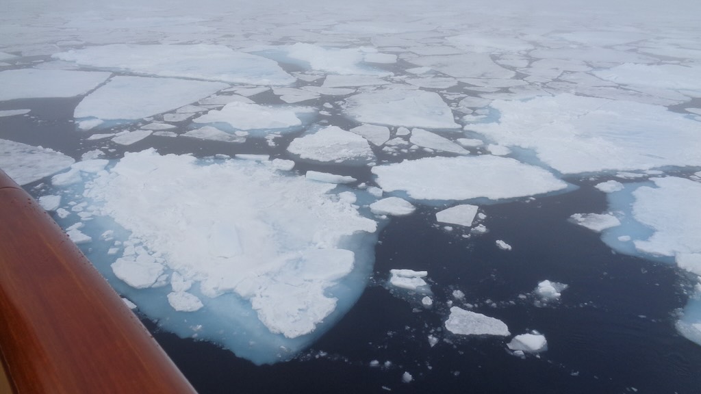
When I checked, the ship was at 81°51.295′ N, 16°59.989′ E, which placed us just north of Svalbard in the Arctic Ocean, close to the ice edge. So the boundary between open water and the onset of sea ice. What we were seeing was patchy floes, occasional solid ice.
On the day satellite-based sea-ice maps (e.g. AMSR2, NSIDC) confirmed that around 82° N near Svalbard, ice concentration dropped below 15‑20 %, signalling the ice edge.
This position meant that we were ~904 km to the North Pole (about 490 nautical miles).
The 15% or 20% sea ice concentration threshold is both a scientific and operational way to define where significant sea ice begins or ends, and it’s surprisingly precise. Sea ice concentration refers to the fraction (or percentage) of a given area that is covered by sea ice. So, a “15% concentration” means that 15% of a defined area (usually 25 square-km or 6.25 square-km grid cells in satellite maps) is covered by sea ice, and 85% is open water.
So the 15% is a practical threshold, and below 15%, most vessels can navigate freely. However, above 15%, floating ice begins to interfere with ship navigation. The “ice edge” is typically defined as the contour where sea ice concentration drops below 15%.
We actually continued a little more and end at 81°59.005′ N, before turning back.
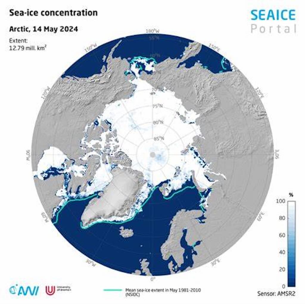
Above we have a satellite-derived sea‑ice concentration map from May 2024, including the region around Svalbard. What this showed was Svalbard’s northern waters largely open, with ice beginning several tens of kilometers north. The 15% ice edge is marked in faint shading where ice concentration picks up. That line sits around 82°N, so very close to our final position 81.59°N this week. South of the edge lies mostly open water. North of it, patches of floes and drizzle mix with first‑year pack ice.
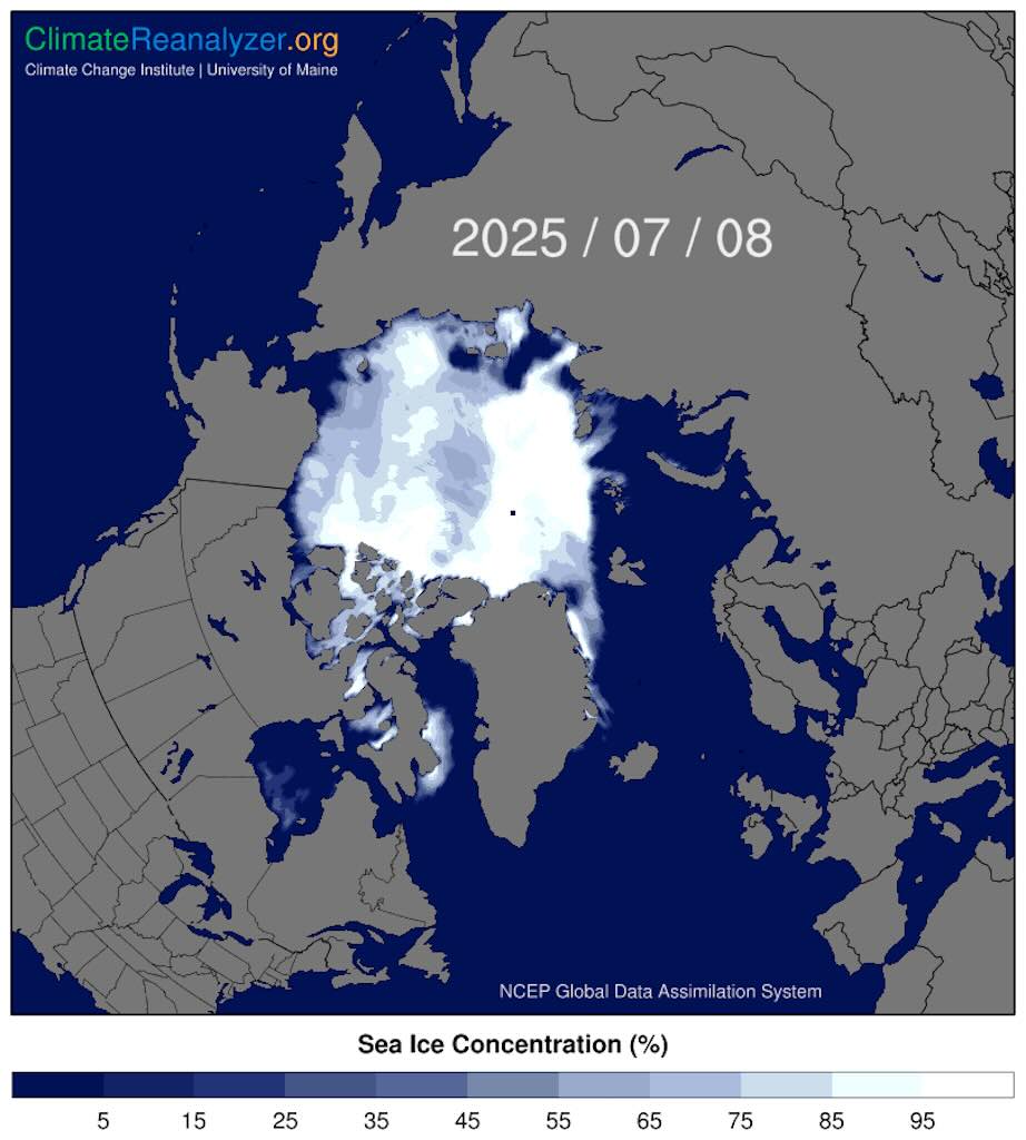
Below we have a general map showing sea ice for the previous day, the 8 July 2025. The little black dot is the North Pole.
The Ocean Explorer is a Polar Class 6 expedition vessel. That means it’s ice-strengthened for seasonal operation in medium first-year ice, but not deep into multi-year pack ice. The ship has a strengthened bow and stern, reinforced hull plating and internal framing, and a special coatings to reduce ice abrasion.
It also means that the ship has ice radar, a protected propeller and rudder, and heated ballast tanks. The crew must also be ice navigation trained.
A rough analysis of the video shows a 30–50% concentration, which lines up well with being within the marginal ice zone, i.e. the transition area where floes start appearing dense. What we see in the video are moderate floes, confirming that we were just inside the 15% contour.
According to satellite images the ice edge (~15% sea ice) was just north of our final position when we turned back.
But whats the difference between the ice edge threshold (15%) and the observed concentration (30–50%)?
The 15% threshold defines the location of the sea ice edge on satellite-derived charts. It marks the southernmost limit where sea ice begins to appear in notable, navigationally significant concentrations. It’s a boundary, not a zone. So any location north of that line will have >15% ice concentration.
Based on satellite data, the 15% sea ice contour was just south or at our location. This meant that we were at or just north of the ice edge. Therefore, the sea ice concentration around you was logically >15%. The video confirmed that, i.e. the visual estimate of 30–50% matches being inside the marginal ice zone, just beyond the edge.
So in very simple terms we went inside the “ice edge”.
But as we advanced towards 82°, we could see that the 30-50% coverage was a localised figure, and that there were both open water areas and dense ice fields, and their distribution was surprisingly complex. Firstly, it’s possible that strong offshore winds blow ice away from the coast. And secondly, upwelling of warm water can melt ice from below (especially in areas with strong ocean currents or mixing). Then wind shear, ocean currents and tidal forces can break up an ice field and create very large openings, several kilometres wide.
All these effects can create areas of open water surrounded by sea ice, which are defined as polynyas, i.e. open-water regions deep within the ice zone, often biologically rich.
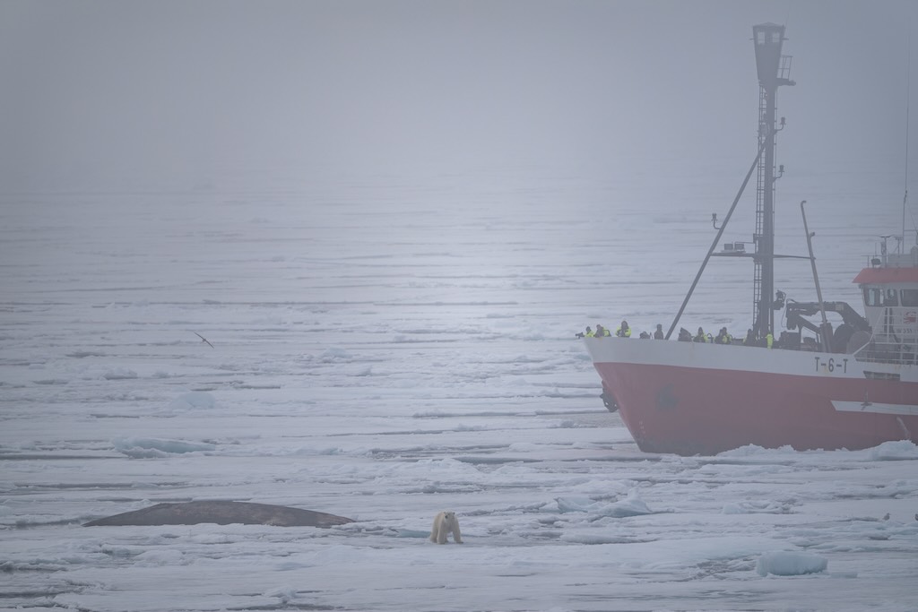
Initially a short trip out in a zodiac was arranged after lunch. However, the message came in that there was a polar bear enjoying eating a whale “on ice”. Two smaller ships were already there, and so our ship “set sail” to join them. It was a bit of a dud, unless you had a powerful telephoto lens. Most people just saw another white blob.
So it was back to the short zodiac outing to “feel” the ice, followed, by those who dared, the polar plunge.
But the real non-question was, did I set foot inside the Arctic Circle?
And of course the obvious answer in yes. In fact, the whole of Svalbard is inside the Arctic Circle, because it’s well North of the latitude 66°33′ North (Svalbard spans between about 74° and 81° North).
So what so important about 82°N?
Historically, 82°N marked the furthest north reached by explorers for centuries. In fact, the British explorer William Edward Parry (1790-1855) reached 82°45′N in 1827, and this record stood for nearly 50 years.
Also, between 81°N and 82°N, the length of polar day and night becomes extremely exaggerated, tundra transitions into polar desert, and multi-year-old ice dominates, with thick, old ice replacing fresh one-year-old ice.
10 July 2025 (Day 8)
We left our position 81°59.005′ N at about 16:00 and arrived at Ytre Norskøya the next morning at around 06:00 (14 hours). The distance was approximately 180 nautical miles, which ment that Ocean Explorer’s average speed was ~13 knots, a bit faster than its usual cruising speed.
08:30 Ytre Norskøya (zodiac cruise/zodiac landing/walk)
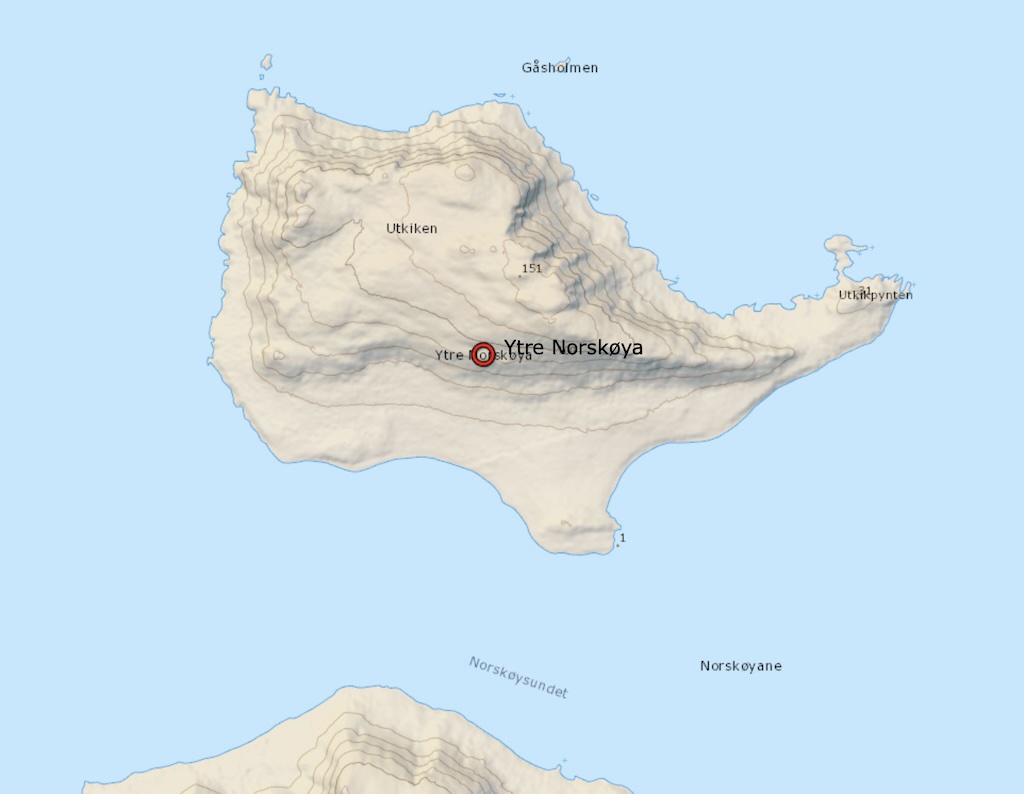
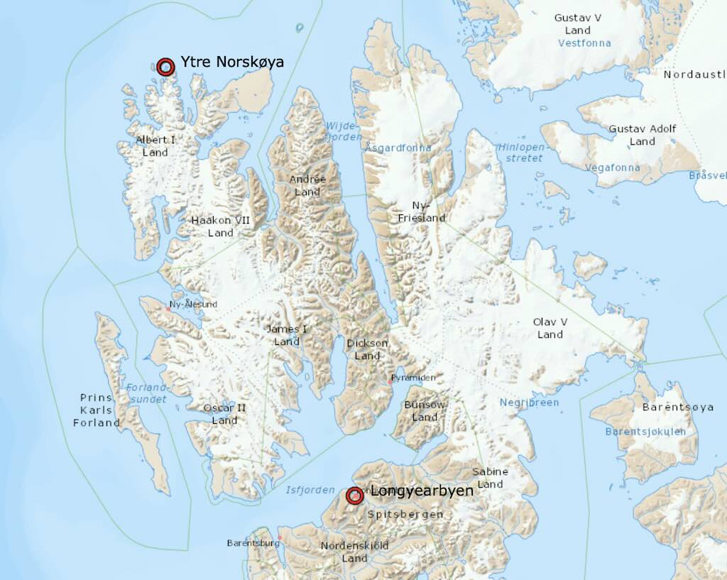
Ytre Norskøya (“Outer Norwegian Island”) is a small island located off the northwest coast of Spitsbergen, the largest island in the Svalbard archipelago.
It was a major base for Dutch whaling operations between 1617 and 1670. There are over 150 marked graves, one of the largest known 17th-century European Arctic burial grounds. My understanding is that they cannot be visited, but it is possible to climb to the highest point on the island which was used as a whalers’ lookout to spot whales offshore.
This was to be our last outing, and we were all given the option to land and walk up to the lookout, or stay on the zodiac and circle the island. I decided to circle the island.
As we entered the channel separating the island from the mainland, spotters informed up that there were Beluga whales near the coast. We managed to see them, and the spotters estimated that the “pod” consisted of up 50 Belugas. A truly rare sight, and a wonderful way to finish our trip to the Arctic.
For me it was a unique experience, and it is true that many of the explorer experts were also pleasantly surprised.
However, Beluga whales (Delphinapterus leucas) are year-round residents in Svalbard waters, particularly in ice-free coastal areas, fjords, and shallow shelves. In fact Belugas prefer shallow, coastal areas, often near glacial fronts, estuaries, or bays, not necessarily open coastlines.
Belugas are often seen in small pods (3–10), but large aggregations of 30 to over 100 individuals are not uncommon in the Arctic during the summer months, especially in those shallow coastal waters where they feed.
Say what you will, we all felt we were privileged to see them close up.
12:00 Disembarking Briefing
A short meeting covered the essential, namely:-
- Pay any outstanding bills (credit card or in $)
- Leave tips for crew and explorer experts
- Collect passport next morning after 06:00
- Prepare luggage, to be placed the next morning outside cabins at 07:30
- Breakfast was from 06:00
- Disembarking was organised according to zodiac colours (mine was blue).
11 July 2025 (Day 9)
Our final trip was Ytre Norskøya back to Longyearbyen, a total of about 120 nautical miles. We left around 15:00 and were scheduled to dock around 07:00 the next morning, so a very comfortable 16 hours travel time.
09:00 Disembarking at Longyearbyen
We arrive at around 07:45, and were docked at around 08:15.
The routine was that:-
- I had paid my extras the night before, and received as receipt
- Passports could be picked up at 06:15
- Luggage had to be outside my cabin by 07:30, we would again see our suitcases at the airport for check-in
- Breakfast was served at 07:30-08:30 only in the Main Dining Room
- Disembarkation was programmes based upon “zodiac colour, mine was blue so I was in the last group at 09:00.
In harbour were:-
- NORBJORN is a 87m general cargo/mini-bunker, flagged in Norway. It is a regular supply ship on the Tromsø–Svalbard route (also serves Ny-Ålesund and Barentsburg). It delivers cargo and provisions to the settlements.
- HANSEATIC SPIRIT is a 139m ice-class expedition cruise ship, built in 2021, and flagged in Malta. Completing a 10-day Tromsø-Longyearbyen voyage, including landings across Svalbard. It docked today with guests aboard.
- TOOTHWALKER is a ~13 metre long sail/expedition yacht providing local charters and wildlife trips.
- LINDEN is a 49 metre long sailing yacht/schooner from 1993. As far as I know it’s used for educational voyages and small-group expeditions.
- BARD is a recently built (2023) 26 metre long local shuttle or coastal tour vessel. It can ferry passengers as well as support shore excursions.
- BILLEFJORD is a 35 metre long providing local excursions and transfers around Svalbard.
- FUGRO DISCOVERY is a 50 metre long research/survey vessel built 1997. It conducts hydrographic and geophysical surveys (e.g. mapping seabed, etc.) in the Svalbard area.
- WORLD VOYAGER is a ~120 metre long, polar-class expedition cruise ship
- SH VEGA is Swan Hellenic’s modern expedition ship, ~113 metre long, built in 2022).
- NORSEL is our oil-products tanker (built 2003).
- EXPLORIS ONE is the former Silver Explorer, a 108 metre long ice-strengthened expedition cruise ship, built in 1989.
09:30 Visit to the Svalbard Museum
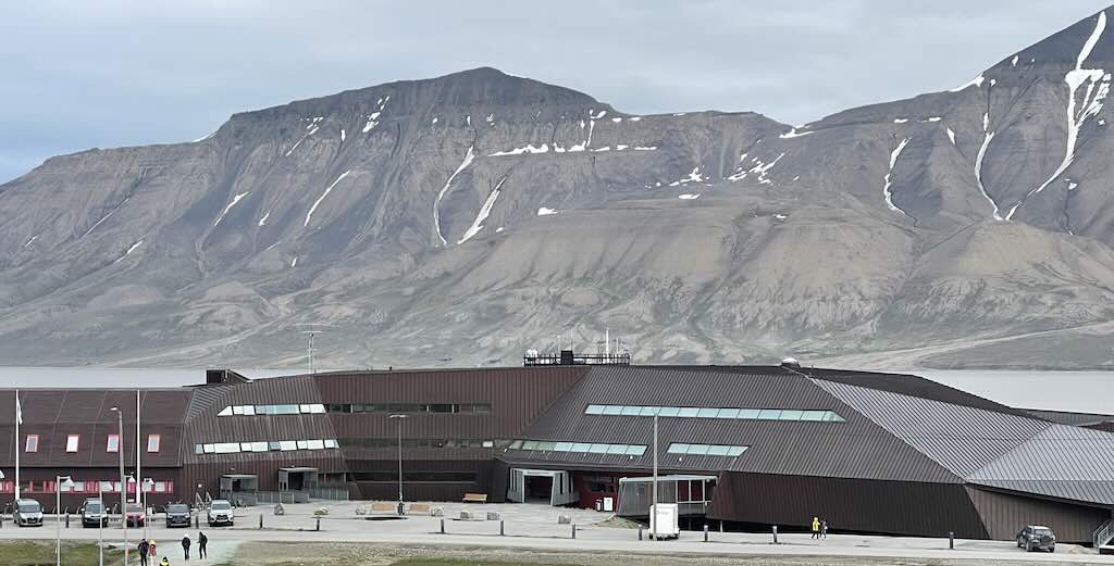
Once picked up by our coach we had a two hour tourist trip, before being dumped in the town.
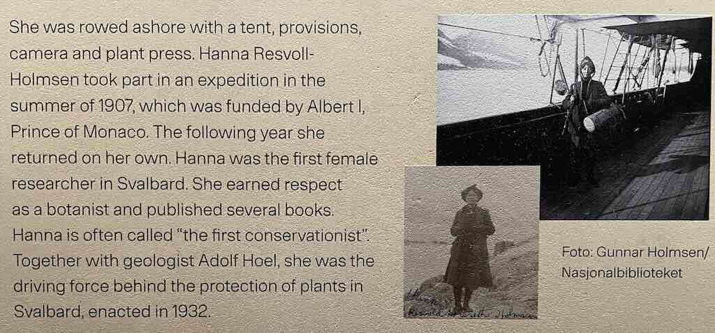
It turned out to be small, but very well presented and interesting museum. In memory of my wife, who would have devoured all the explanations and descriptions, I have included below the mention of two powerful women, Léonie d’Aunet and Hanna Resvoll-Holmsen.

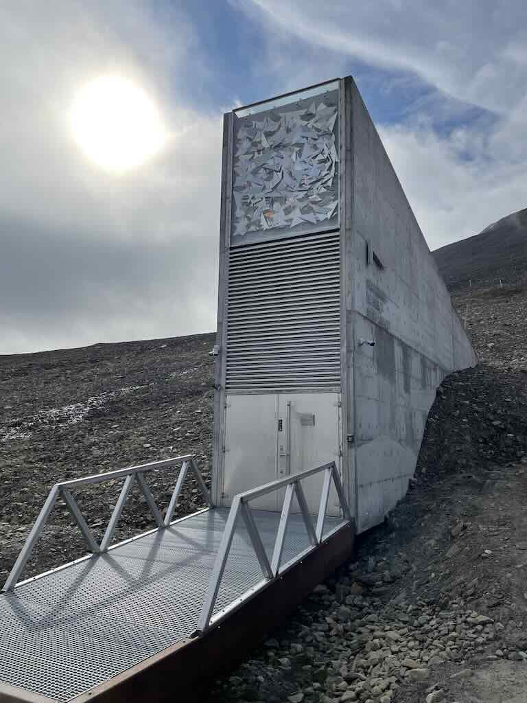
We then drove a short distant up to the Svalbard Global Seed Vault. It’s not the most compelling building, but it’s a secure seed storage facility located inside a permafrost mountain known as Platåberget, near Longyearbyen.
The primary purpose is to act as a global backup storage site for the preservation of crop seeds. It was built to safeguard the genetic diversity of the world’s crops in the event of regional or global catastrophes such as war, natural disaster, climate change, or mismanagement (otherwise know as stupidity). It functions as a secure repository of duplicate seed samples from gene banks around the world, so it’s a “backup of backups” for agricultural biodiversity.
The seed vault is constructed approximately 120 meters into the rock, which provides natural insulation and protection. The cold climate and geological stability of the region make it an ideal site for long-term storage. Seeds are kept in sealed, three-layer foil packages inside boxes, and stored at –18 degrees Celsius. Even if refrigeration systems fail, the permafrost helps maintain a low enough temperature to preserve the seeds for long periods. Designed to withstand extreme scenarios, the vault is resistant to earthquakes, flooding, and even nuclear conflict. Its location, high above sea level and within solid rock, was carefully selected to ensure long-term survivability even in the face of worsening climate change.
As of 2025, the vault houses over 1.2 million seed samples, representing more than 6,000 plant species.
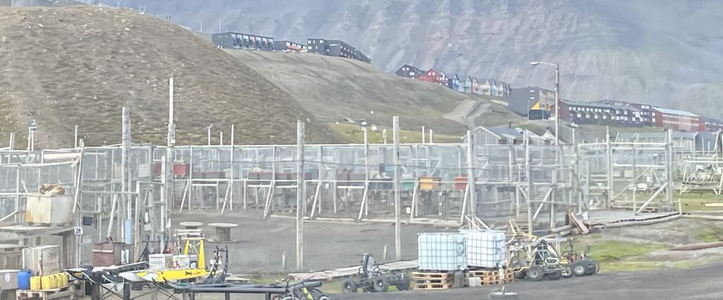
11:30 Time in Longyearbyen
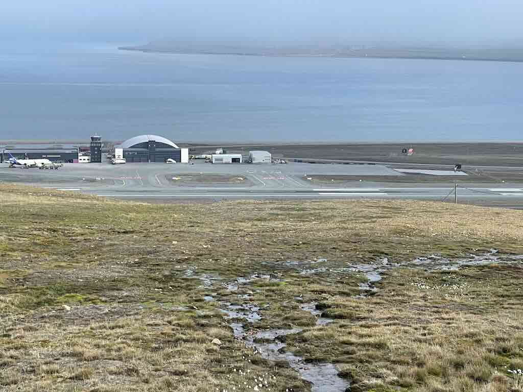
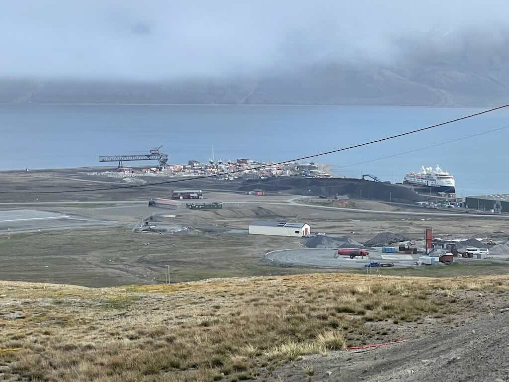
We were driven around a bit to see the local countryside, before being dumped in Longyearbyen to wait 2½ hours for the coach to the airport. In the distance we could see the airport and the Ocean Explorer docked, and waiting for its next load of passengers.
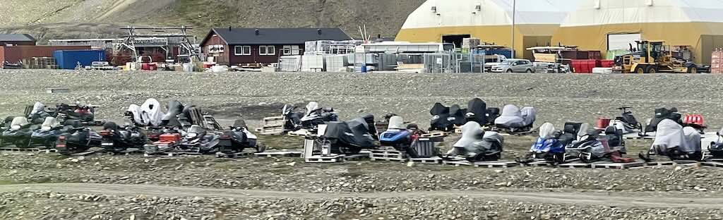
There were snowmobiles scattered all over the place, waiting for snow. A recent estimate was that there were over 4,000 snowmobiles registered to around 2,400 people.
A new snowmobile typically costs €9,000–€18,000, depending on the model, and to drive one you need a valid driver’s license recognised in Norway.
We also drove past one of the kennel farms where the dogs are kept. It may appear as if they were poorly treated, but the guide pointed out they are in fact very precious working dogs, and are very well treated.
There are 300-400 sled dogs in and around Longyearbyen. They must be registered with the Governor of Svalbard (Sysselmesteren), and owners are responsible for their vaccination, care, and safety.
There are at least three types of dog used, the Greenland Dog (strong, sturdy, and suited for hauling heavy loads), Alaskan Husky (mixed breed developed for racing and efficiency, and common in Svalbard), and the Siberian Husky (smaller and faster, more often used in tourist tours).
They each have a role to play in a “team”. The Alaskan Husky is the most common lead dog due to high intelligence and trainability, although the Siberian Husky is also intelligent and focused, but is better for shorter distances or more recreational teams. Alaskan Husky are again very common in swing positions, i.e. to reinforce the leader’s commands and help guide the team around curves. The Greenland Dog is an excellent team dog due to sheer strength and stamina. And the Greenland Dog is also an ideal wheel dog. It’s powerful, muscular, and built for deep snow and heavy loads. Wheel dogs absorb the brunt of the sled’s weight at startup and during turns, so only the most powerful and steady dogs are used there.
The guide pointed out that it was not just a question of attaching the dogs, and running. Each dog has its preferences for both position and running companion. Some dogs prefer to be with friends, others like to be out in front, and others want to near the driver. Talk about social networking!
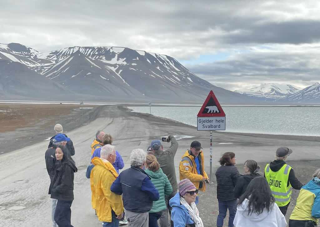
Lastly, everyone (almost) wanted to drive out to see the “beware the bear” sign, that defines the town limit, and where beyond, people must be armed. In fact, the sign actually says “Applies to all of Svalbard”.
We are lucky that polar bears have not leant that everyday tourists drive up, stand in the same place taking photos, and are unarmed (even the guide).
I stayed on the coach, the drive had told me he was armed.